190.120.31.223 - IP Lookup: Free IP Address Lookup, Postal Code Lookup, IP Location Lookup, IP ASN, Public IP
Country:
Region:
City:
Location:
Time Zone:
Postal Code:
ISP:
ASN:
language:
User-Agent:
Proxy IP:
Blacklist:
IP information under different IP Channel
ip-api
Country
Region
City
ASN
Time Zone
ISP
Blacklist
Proxy
Latitude
Longitude
Postal
Route
db-ip
Country
Region
City
ASN
Time Zone
ISP
Blacklist
Proxy
Latitude
Longitude
Postal
Route
IPinfo
Country
Region
City
ASN
Time Zone
ISP
Blacklist
Proxy
Latitude
Longitude
Postal
Route
IP2Location
190.120.31.223Country
Region
san salvador
City
apopa
Time Zone
America/El_Salvador
ISP
Language
User-Agent
Latitude
Longitude
Postal
ipdata
Country
Region
City
ASN
Time Zone
ISP
Blacklist
Proxy
Latitude
Longitude
Postal
Route
Popular places and events near this IP address

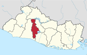
San Salvador Department
Department of El Salvador
Distance: Approx. 8708 meters
Latitude and longitude: 13.731,-89.161
San Salvador (Spanish pronunciation: [san salβaˈðoɾ]) is a department of El Salvador in the west central part of the country. The capital is San Salvador, which is also the national capital. The department has North of the Rio Lempa Valley, the "Valle de las Hamacas" (Hammock Valley) and a section of Lake Ilopango.
Cuscatancingo
District in San Salvador Department, El Salvador
Distance: Approx. 8235 meters
Latitude and longitude: 13.73333333,-89.18333333
Cuscatancingo is a district in the San Salvador department of El Salvador. It is located about 4 kilometres (2.5 mi) from the city of San Salvador and has a population of about 50,000. It is part of the San Salvador metropolitan area.

Guazapa
Municipality in San Salvador
Distance: Approx. 8583 meters
Latitude and longitude: 13.88333333,-89.16666667
Guazapa is a district in San Salvador Norte Municipality in the San Salvador Department of El Salvador.

Mejicanos
District in San Salvador Department, El Salvador
Distance: Approx. 9166 meters
Latitude and longitude: 13.73333333,-89.21666667
Mejicanos is a district of San Salvador Centro municipality in the San Salvador department of El Salvador. Mejicanos is a city located in San Salvador Department and part of the San Salvador metropolitan area. At the 2009 estimate it had 160,751 inhabitants.

Nejapa
District in San Salvador Department, El Salvador
Distance: Approx. 5946 meters
Latitude and longitude: 13.81666667,-89.23333333
Nejapa is a district in the San Salvador department of El Salvador. It is part of the San Salvador metropolitan area.
Tonacatepeque
District in San Salvador Department, El Salvador
Distance: Approx. 7264 meters
Latitude and longitude: 13.78333333,-89.11666667
Tonacatepeque is a district in the San Salvador department of El Salvador. It has a population of 90,896 inhabitants according to the 2007 Census. This makes this municipality twelfth largest in terms of population in El Salvador.

Soyapango
District in San Salvador Department, El Salvador
Distance: Approx. 8808 meters
Latitude and longitude: 13.73333333,-89.15
Soyapango is a district in the San Salvador department of El Salvador. Soyapango is the country's largest municipality with 284,700 residents. Soyapango is a satellite city of San Salvador and it is the main thoroughfare between San Salvador and the eastern part of the country, and nearly 70,000 vehicles travel through it every day.

San José Guayabal
Municipality in Cuscatlán Department, El Salvador
Distance: Approx. 9797 meters
Latitude and longitude: 13.85,-89.1
San José Guayabal is a municipality in the Cuscatlán department of El Salvador.
1986 San Salvador earthquake
1986 earthquake in Central America
Distance: Approx. 9152 meters
Latitude and longitude: 13.75,-89.24
The 1986 San Salvador earthquake occurred at 11:49:26 local time on 10 October 1986 with a moment magnitude of 5.7 and a maximum Mercalli intensity of IX (Violent). The shock caused considerable damage to El Salvador's capital city of San Salvador and surrounding areas, including neighboring Honduras and Guatemala.
Polideportivo Vitoria-Gasteiz
Distance: Approx. 5441 meters
Latitude and longitude: 13.8175,-89.2284
Polideportivo Vitoria-Gasteiz is a multi-use sports complex located in Nejapa, El Salvador. The sports complex is mainly used for its soccer facility. The soccer field is the home field of Alacranes Del Norte, a first division soccer team with a capacity of 2,000.
Estadio Universitario (UES)
Distance: Approx. 9864 meters
Latitude and longitude: 13.72138889,-89.20194444
Estadio Universitario (UES) is a multi-use stadium in San Salvador, El Salvador. It is currently used mostly for football matches and is the home stadium of C.D. UES. The stadium holds 10,000 people.
Cuscatlán Formation
Distance: Approx. 2387 meters
Latitude and longitude: 13.8,-89.2
The Cuscatlán Formation is a geologic formation in El Salvador. It preserves fossils dating back to the Pliocene to Middle Pleistocene (Blancan to Irvingtonian) period.
Weather in this IP's area
clear sky
28 Celsius
29 Celsius
24 Celsius
28 Celsius
1018 hPa
61 %
1018 hPa
949 hPa
10000 meters
8.23 m/s
320 degree

