190.120.25.179 - IP Lookup: Free IP Address Lookup, Postal Code Lookup, IP Location Lookup, IP ASN, Public IP
Country:
Region:
City:
Location:
Time Zone:
Postal Code:
IP information under different IP Channel
ip-api
Country
Region
City
ASN
Time Zone
ISP
Blacklist
Proxy
Latitude
Longitude
Postal
Route
Luminati
Country
Region
sa
City
santaelena
ASN
Time Zone
America/El_Salvador
ISP
Navega.com S.A.
Latitude
Longitude
Postal
IPinfo
Country
Region
City
ASN
Time Zone
ISP
Blacklist
Proxy
Latitude
Longitude
Postal
Route
IP2Location
190.120.25.179Country
Region
usulutan
City
usulutan
Time Zone
America/El_Salvador
ISP
Language
User-Agent
Latitude
Longitude
Postal
db-ip
Country
Region
City
ASN
Time Zone
ISP
Blacklist
Proxy
Latitude
Longitude
Postal
Route
ipdata
Country
Region
City
ASN
Time Zone
ISP
Blacklist
Proxy
Latitude
Longitude
Postal
Route
Popular places and events near this IP address

Usulután Department
Department of El Salvador
Distance: Approx. 8115 meters
Latitude and longitude: 13.376,-88.52
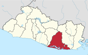
Usulután (Spanish pronunciation: [usuluˈtan]; from the Nawat language, meaning "city of the ocelots") is a department of El Salvador in the southeast of the country (Lenca region). The capital is Usulután. Created on June 22, 1865, it is El Salvador's largest department.

Usulután
Municipality in Usulután Department, El Salvador
Distance: Approx. 0 meters
Latitude and longitude: 13.35,-88.45
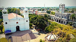
Usulután (Spanish pronunciation: [usuluˈtan]) is the fifth largest city in El Salvador, and capital of the Usulután Department in the south-east of El Salvador. As of 2006, it is estimated to have population of 71,636 people. Usulután rests in a rich agricultural valley and has very high and humid temperatures most of the year as it is located close to the Pacific Ocean.

Ereguayquín
Distance: Approx. 7221 meters
Latitude and longitude: 13.35,-88.38333333
Ereguayquín is a municipality in the Usulután department of El Salvador.
Ozatlán
Municipality of the Usulután Department of El Salvador
Distance: Approx. 6565 meters
Latitude and longitude: 13.38333333,-88.5
Ozatlán is a municipality in the Usulután department of El Salvador. The city of Ozatlán was named in the 1970s by the governor of El Salvador. This city was recently rebuilt, with a new central park and business district.
San Dionisio, El Salvador
Municipality in El Salvador
Distance: Approx. 7638 meters
Latitude and longitude: 13.28333333,-88.46666667
San Dionisio is a municipality in the Usulután department of El Salvador.
Santa Elena, El Salvador
City in Usulután Department, El Salvador
Distance: Approx. 5177 meters
Latitude and longitude: 13.38333333,-88.41666667
Santa Elena is a city in the Usulután department of El Salvador. The city is known for hosting gold mines.
Santa María, El Salvador
Municipality in Usulután Department, El Salvador
Distance: Approx. 1805 meters
Latitude and longitude: 13.35,-88.43333333
Santa María is a municipality in the Usulután department of El Salvador.
Sergio Torres Stadium
Multi-purpose stadium in Usulután, El Salvador
Distance: Approx. 1324 meters
Latitude and longitude: 13.34972222,-88.43777778
Estadio Sergio Torres is a multi-purpose stadium in Usulután, El Salvador. It is currently used mostly for football matches and is the home stadium of Luis Ángel Firpo. The stadium holds 5,000 people.
El Molino River
River in El Salvador
Distance: Approx. 9688 meters
Latitude and longitude: 13.262973,-88.449974
El Molino River (Rio El Molino) is the name of two medium streams in El Salvador. 13°15′47″N 88°27′00″W, near the Jiquilisco Bay in Usulután District. 13°57′N 89°57′W, near the city of Ahuachapán in Ahuachapán District.
Casas Nuevas Airport
Airstrip in Usulután Department, El Salvador
Distance: Approx. 7626 meters
Latitude and longitude: 13.30972222,-88.50694444
Casas Nuevas Airport (ICAO: MSCN) is an airstrip serving the city of Jiquilisco in Usulután Department, El Salvador. The unmarked grass runway is 7 kilometres (4.3 mi) east of the city.
La Carrera Airport
Airport
Distance: Approx. 8015 meters
Latitude and longitude: 13.32916667,-88.52083333
La Carrera Airport (ICAO: MSCR) is an airport serving the city of Jiquilisco in Usulután Department, El Salvador. The runway is 5 kilometres (3.1 mi) east of Jiquilisco.
Usulután Airport
Airport
Distance: Approx. 5896 meters
Latitude and longitude: 13.33333333,-88.50166667
Usulután Airport is an airstrip serving the city of Usulután in Usulután Department, El Salvador. It is 6 kilometres (3.7 mi) west of the city on highway CA2E. There is a hangar and fueling tank next to the north end of the runway.
Weather in this IP's area
broken clouds
25 Celsius
26 Celsius
25 Celsius
25 Celsius
1013 hPa
64 %
1013 hPa
988 hPa
10000 meters
1.69 m/s
2.23 m/s
42 degree
70 %