190.120.23.122 - IP Lookup: Free IP Address Lookup, Postal Code Lookup, IP Location Lookup, IP ASN, Public IP
Country:
 El Salvador
Region:
City:
Location:
Time Zone:
Postal Code:
ISP:
ASN:
language:
User-Agent:
Proxy IP:
Blacklist:
IP information under different IP Channel
ip-api
Country
Region
City
ASN
Time Zone
ISP
Blacklist
Proxy
Latitude
Longitude
Postal
Route
db-ip
Country
Region
City
ASN
Time Zone
ISP
Blacklist
Proxy
Latitude
Longitude
Postal
Route
IPinfo
Country
Region
City
ASN
Time Zone
ISP
Blacklist
Proxy
Latitude
Longitude
Postal
Route
IP2Location
190.120.23.122Country
svRegion
san salvador
City
ilopango
Time Zone
America/El_Salvador
ISP
Language
User-Agent
Latitude
Longitude
Postal
ipdata
Country
Region
City
ASN
Time Zone
ISP
Blacklist
Proxy
Latitude
Longitude
Postal
Route
Popular places and events near this IP address
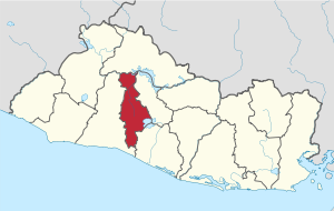
San Salvador Department
Department of El Salvador
Distance: Approx. 6464 meters
Latitude and longitude: 13.731,-89.161
San Salvador (Spanish pronunciation: [san salβaˈðoɾ]) is a department of El Salvador in the west central part of the country. The capital is San Salvador, which is also the national capital. The department has North of the Rio Lempa Valley, the "Valle de las Hamacas" (Hammock Valley) and a section of Lake Ilopango.

Delgado, El Salvador
District in San Salvador Department, El Salvador
Distance: Approx. 6413 meters
Latitude and longitude: 13.71666667,-89.16666667
Ciudad Delgado is a district in the San Salvador department of El Salvador. It is a part of the Metropolitan Area of San Salvador.
Ilopango
District in San Salvador Department, El Salvador
Distance: Approx. 808 meters
Latitude and longitude: 13.7,-89.11666667
Ilopango is a town and district in the San Salvador department of El Salvador. It is a few miles east of the nation's capital, San Salvador and part of the San Salvador metropolitan area. It is located near Lake Ilopango, the country's largest lake at 72 square kilometers.

Santiago Texacuangos
District in San Salvador Department, El Salvador
Distance: Approx. 5809 meters
Latitude and longitude: 13.65,-89.11666667
Santiago Texacuangos is a district in the San Salvador department of El Salvador. It is near Lake Ilopango.

Soyapango
District in San Salvador Department, El Salvador
Distance: Approx. 5628 meters
Latitude and longitude: 13.73333333,-89.15
Soyapango is a district in the San Salvador department of El Salvador. Soyapango is the country's largest municipality with 284,700 residents. Soyapango is a satellite city of San Salvador and it is the main thoroughfare between San Salvador and the eastern part of the country, and nearly 70,000 vehicles travel through it every day.

La Matanza
1932 peasant revolt in El Salvador
Distance: Approx. 7299 meters
Latitude and longitude: 13.666,-89.166
La Matanza (Spanish for 'The Massacre') refers to a communist-Indigenous rebellion that took place in El Salvador between 22 and 25 January 1932. After the revolt was suppressed, it was followed by large-scale government killings in western El Salvador, which resulted in the deaths of 10,000 to 40,000 people. Another 100 soldiers were killed during the suppression of the revolt.

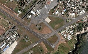
Ilopango International Airport
Regional airport located in Ilopango, San Salvador, El Salvador
Distance: Approx. 2074 meters
Latitude and longitude: 13.69166667,-89.12555556
Ilopango International Airport (IATA: ILS, ICAO: MSSS) is an airport located on the eastern part of the city of San Salvador, El Salvador, once serving the city as its international airport until 1980 when it was replaced by the larger and more modern El Salvador International Airport, located about 50 km south of the city. Currently, Ilopango is used for military, air taxi, and charter aviation only. It also holds the annual Ilopango Air Show.

Arrupe College, El Salvador
Private primary and secondary school in Soyapango, San Salvador, El Salvador
Distance: Approx. 5560 meters
Latitude and longitude: 13.71861111,-89.15777778
Arrupe College, El Salvador, is a private Catholic primary and secondary school located in Soyapango, a high-density, low-income area in San Salvador, the capital city of El Salvador. The school was founded by a Father Juan Ricardo Salazar-Simpson in 1997 and it was built and remains largely supported by charitable contributions. The school includes infant through baccalaureate and vocational, and has ranked at the top on national exams.
Battle of Ilopango Airport
1982 military engagement in El Salvador
Distance: Approx. 2074 meters
Latitude and longitude: 13.69166667,-89.12555556
The Battle of Ilopango Airport was a military engagement fought at the Ilopango International Airport in El Salvador in late January 1982. The battle was a part of the Salvadoran Civil War. It was fought between soldiers of the Salvadoran Air Force and guerrillas of the Farabundo Martí National Liberation Front.
1965 San Salvador earthquake
1965 earthquake in Central America
Distance: Approx. 4743 meters
Latitude and longitude: 13.683,-89.07
The 1965 San Salvador earthquake occurred at 04:01 in the morning on May 3, 1965. It had a moment magnitude of 5.9 and a maximum Mercalli intensity of VIII (Severe). The shock caused severe damage to El Salvador's capital city, San Salvador.

Blockade of Soyapango
Event of the 2022 Salvadoran gang crackdown
Distance: Approx. 3283 meters
Latitude and longitude: 13.70972222,-89.13861111
The blockade of Soyapango was a Salvadoran government operation to arrest criminal gang members of Mara Salvatrucha (MS-13) and 18th Street gang in the city of Soyapango. The operation began on 3 December 2022 when Salvadoran President Nayib Bukele announced that 10,000 members of the country's security forces surrounded the city. As of January 2023 the active phase of the blockade has been completed; however, security forces are still engaged in removing gang related symbols and the security setup in the area has been enhanced.
Plaza Mundo
Shopping mall chain
Distance: Approx. 4464 meters
Latitude and longitude: 13.698,-89.1505
Plaza Mundo is a chain of shopping malls owned by real estate group Grupo Agrisal, which is headquartered in El Salvador. As of 2023, Plaza Mundo has two shopping malls located in Soyapango and Apopa, with one in Usulután currently being under construction.
Weather in this IP's area
scattered clouds
22 Celsius
23 Celsius
21 Celsius
22 Celsius
1014 hPa
84 %
1014 hPa
943 hPa
10000 meters
1.62 m/s
2.11 m/s
339 degree
31 %