190.111.7.136 - IP Lookup: Free IP Address Lookup, Postal Code Lookup, IP Location Lookup, IP ASN, Public IP
Country:
Region:
City:
Location:
Time Zone:
Postal Code:
IP information under different IP Channel
ip-api
Country
Region
City
ASN
Time Zone
ISP
Blacklist
Proxy
Latitude
Longitude
Postal
Route
Luminati
Country
Region
21
City
miraflores
ASN
Time Zone
America/Guatemala
ISP
Navega.com S.A.
Latitude
Longitude
Postal
IPinfo
Country
Region
City
ASN
Time Zone
ISP
Blacklist
Proxy
Latitude
Longitude
Postal
Route
IP2Location
190.111.7.136Country
Region
quetzaltenango
City
quetzaltenango
Time Zone
America/Guatemala
ISP
Language
User-Agent
Latitude
Longitude
Postal
db-ip
Country
Region
City
ASN
Time Zone
ISP
Blacklist
Proxy
Latitude
Longitude
Postal
Route
ipdata
Country
Region
City
ASN
Time Zone
ISP
Blacklist
Proxy
Latitude
Longitude
Postal
Route
Popular places and events near this IP address

Quetzaltenango
City in Guatemala
Distance: Approx. 5 meters
Latitude and longitude: 14.83333333,-91.51666667
Quetzaltenango (Spanish pronunciation: [ketsalteˈnaŋɡo], also known by its Maya name Xelajú [ʃelaˈχu] or Xela [ˈʃela]) is both the seat of the namesake Department and municipality, in Guatemala. The city is located in a mountain valley at an elevation of 2,330 meters (7,640 feet) above sea level at its lowest part. It may reach above 2,400 m (7,900 ft) within the city.

Quetzaltenango Department
Department of Guatemala
Distance: Approx. 1415 meters
Latitude and longitude: 14.84583333,-91.51888889
Quetzaltenango is a department in the western highlands of Guatemala. The capital is the city of Quetzaltenango, the second largest city in Guatemala. The department is divided up into 24 municipalities.

Almolonga
Stratovolcano in Guatemala
Distance: Approx. 3724 meters
Latitude and longitude: 14.8,-91.52
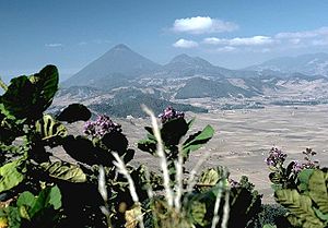
The Almolonga volcano, also called "Cerro Quemado" (Burned Mountain) or "La Muela" (The Molar) due to its distinct shape, is an andesitic stratovolcano in the south-western department of Quetzaltenango in Guatemala. Part of the mountain range of the Sierra Madre, the volcano is located near the town of Almolonga, just south of Quetzaltenango, Guatemala's second largest city. The volcano is set along the Zunil fault zone and has a central caldera surrounded by several dacitic and rhyolitic lava domes and formed in a back-arc volcanic setting, with activity commencing 84,000BP. Almolonga stratovolcano is the oldest edifice and underwent collapse prior to the caldera forming eruption of Lake Atitlan, the major chronological marker of volcanism in the region.
Estadio Mario Camposeco
Distance: Approx. 964 meters
Latitude and longitude: 14.84194444,-91.51722222
The Estadio Mario Camposeco is a football stadium located in Quetzaltenango, Guatemala. It is the home to Liga Nacional club Xelajú (Los Chivos). It has a capacity of 11,220.
Almolonga, Quetzaltenango
Guatemalan town and municipality in Quetzaltenango
Distance: Approx. 3353 meters
Latitude and longitude: 14.81222222,-91.49444444
Almolonga is a town, with a population of 17,613 (2023 census), and a municipality in the Quetzaltenango Department of Guatemala, located on the road between Ciudad de Quetzaltenango (Quetzaltenango City) and Zunil. Its population is primarily indigenous, speaking the K'iche' (Quiché) language The town is known as the "Vegetable Basket of the Americas" (La Hortaliza de las Américas) due to the intense cultivation of vegetables in its vicinity. However, the cultivation relies heavily on pesticides to increase growth and crop size.

Roman Catholic Archdiocese of Los Altos Quetzaltenango-Totonicapán
Roman Catholic archdiocese in Guatemala
Distance: Approx. 133 meters
Latitude and longitude: 14.8336,-91.5179
The Roman Catholic Archdiocese of Los Altos Quetzaltenango-Totonicapán (Latin: Archidioecesis Altensis, Quetzltenanguensis-Totonicapensis) is a Latin Metropolitan Archdiocese in Guatemala. The archiepiscopal seat is Quetzaltenango Cathedral (Catedral del Espíritu Santo), originally built in Quetzaltenango in 1535. It also has a co-cathedral, San Miguel Arcángel, in the city of Totonicapán.

Quetzaltenango Municipal Theatre
Distance: Approx. 572 meters
Latitude and longitude: 14.83798889,-91.51886667
The Quetzaltenango Municipal Theatre, known as the Teatro Municipal is a theatre in Quetzaltenango, Guatemala. The historical building still hosts theatrical presentations and is also noted for its jazz performances which attract many visitors to the theatre.
Hospital Nacional San Juan de Dios
Hospital in Guatemala
Distance: Approx. 3658 meters
Latitude and longitude: 14.85722222,-91.54
The Hospital Nacional San Juan de Dios is a public hospitals in Guatemala. It is located in Quetzaltenango, Guatemala's second largest city. On July 25, 2000 it hit the news when an outbreak of meningitis killed 15 newborn babies and left three others seriously ill.
Cerro El Baúl
National park in Guatemala
Distance: Approx. 1518 meters
Latitude and longitude: 14.83111111,-91.50277778
Cerro El Baúl, also known as El Baúl, is a forested lava dome overlooking the valley of Quetzaltenango. It is located about 3 km north of the Almolonga volcano, at the south-eastern edge of the city of Quetzaltenango in Guatemala. And is one of the city's last remaining green areas.

Quetzaltenango Guatemala Temple
Distance: Approx. 2785 meters
Latitude and longitude: 14.84472222,-91.53972222
The Quetzaltenango Guatemala Temple is the second temple built by the Church of Jesus Christ of Latter-day Saints (LDS Church) in Guatemala. It was the fifth temple of the church in Central America. The temple is located in the western part of the city, near the Parque Zoológico Minerva.
Inter-American School, Quetzaltenango, Guatemala
Distance: Approx. 1996 meters
Latitude and longitude: 14.846,-91.5036
Inter-American School in Quetzaltenango, Guatemala, was founded in 1961 as a Christian school for the children of missionaries serving in Guatemala. Since then, the school has also served the children of many local families. The school runs on an American-style schedule (August to May) and uses the California state standards to assess and document student learning.

Quetzaltenango Cathedral
Church in Quetzaltenango, Guatemala
Distance: Approx. 388 meters
Latitude and longitude: 14.8336634,-91.5202886
The Holy Spirit Cathedral (Spanish: Catedral del Espíritu Santo de Quetzaltenango), also called Quetzaltenango Cathedral, is a Catholic church in Quetzaltenango, Guatemala. It was founded by the conquistadors, shortly after having defeated the legendary local hero Tecun Uman. The city was dedicated by the Spanish to the Holy Spirit.
Weather in this IP's area
few clouds
16 Celsius
15 Celsius
14 Celsius
17 Celsius
1018 hPa
50 %
1018 hPa
782 hPa
10000 meters
1.41 m/s
1.16 m/s
192 degree
13 %

