Country:
Region:
City:
Latitude and Longitude:
Time Zone:
Postal Code:
IP information under different IP Channel
ip-api
Country
Region
City
ASN
Time Zone
ISP
Blacklist
Proxy
Latitude
Longitude
Postal
Route
Luminati
Country
Region
b
City
bahiablanca
ASN
Time Zone
America/Argentina/Buenos_Aires
ISP
Dese Technologies Argentina S.A.
Latitude
Longitude
Postal
IPinfo
Country
Region
City
ASN
Time Zone
ISP
Blacklist
Proxy
Latitude
Longitude
Postal
Route
db-ip
Country
Region
City
ASN
Time Zone
ISP
Blacklist
Proxy
Latitude
Longitude
Postal
Route
ipdata
Country
Region
City
ASN
Time Zone
ISP
Blacklist
Proxy
Latitude
Longitude
Postal
Route
Popular places and events near this IP address

Bahía Blanca
City in Buenos Aires Province, Argentina
Distance: Approx. 145 meters
Latitude and longitude: -38.71666667,-62.26666667
Bahía Blanca (Spanish pronunciation: [baˈi.a ˈβlaŋka]; English: White Bay) is a city by the Atlantic Ocean, in the southwest province of Buenos Aires, Argentina. It is the seat of government of the Bahía Blanca Partido, with 301,572 inhabitants according to the 2010 census [INDEC]. Bahía Blanca is the principal city in the Greater Bahía Blanca area.

Napostá Grande Stream
River in Argentina
Distance: Approx. 8596 meters
Latitude and longitude: -38.79183563,-62.23824234
Napostá Grande Stream is located in the region of Bahía Blanca, Buenos Aires Province, Argentina It is a stream whose watershed is in Sierra de la Ventana, about 120 kilometres (75 mi) northeast to Bahía Blanca. It was essential during the early history of the city of Bahía Blanca as a source of water and also as a natural defense against aborigine. Later on it was useful as a water supply for agriculture.
Comandante Espora Airport
Airport in Bahía Blanca, Argentina
Distance: Approx. 8404 meters
Latitude and longitude: -38.72472222,-62.16916667
Comandante Espora Airport (IATA: BHI, ICAO: SAZB), also known as Bahía Blanca Airport, is a domestic airport in Bahía Blanca, Argentina, which is served by Aerolíneas Argentinas and LADE. Espora is also the main base of the Argentine Naval Aviation, and was given the identifier BACE by the Argentine Navy.

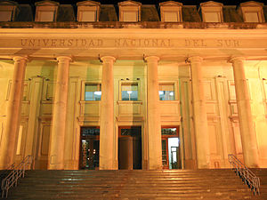
Universidad Nacional del Sur
National university in southern Argentina
Distance: Approx. 1837 meters
Latitude and longitude: -38.70138889,-62.26944444
The National University of the South (in Spanish: Universidad Nacional del Sur, UNS) is the largest national university in southern Argentina. The university was founded on January 5, 1956, and absorbed what had been the Technological Institute of South (Instituto Tecnológico del Sur, ITS), a former National University of La Plata affiliate established in 1946. Located in the city of Bahía Blanca, the school became the sixteenth in Argentina's national university system.

Autódromo Ezequiel Crisol
Circuit
Distance: Approx. 8403 meters
Latitude and longitude: -38.68213889,-62.18011111
Autódromo Ezequiel Crisol, or Autódromo Aldea Romana, is a 3.000 km (1.864 mi) motorsports circuit located in Buenos Aires Province, Argentina. It has hosted events in the Turismo Nacional and TC2000 series.

Bahía Blanca Sud railway station
Railway station in Buenos Aires
Distance: Approx. 1027 meters
Latitude and longitude: -38.72144444,-62.25475
Bahía Blanca Sud (English: Bahía Blanca South) is a railway station of the Argentine rail network, part of the General Roca Railway. Originally built and operated by the Buenos Aires Great Southern Railway, it is located in the city of Bahía Blanca, Buenos Aires Province. In November 2014 the station was declared National Historical Monument by the Argentine government.
Ingeniero White
Town in Buenos Aires, Argentina
Distance: Approx. 5463 meters
Latitude and longitude: -38.76666667,-62.26666667
Ingeniero White is a town located in the Bahía Blanca Partido of Buenos Aires Province, Argentina.
Weather in this IP's area
broken clouds
24 Celsius
23 Celsius
24 Celsius
24 Celsius
1004 hPa
48 %
1004 hPa
1001 hPa
10000 meters
3.58 m/s
7.15 m/s
274 degree
57 %
05:46:27
20:01:17