Country:
 Colombia
Region:
City:
Latitude and Longitude:
Time Zone:
Postal Code:
IP information under different IP Channel
ip-api
Country
Region
City
ASN
Time Zone
ISP
Blacklist
Proxy
Latitude
Longitude
Postal
Route
IPinfo
Country
Region
City
ASN
Time Zone
ISP
Blacklist
Proxy
Latitude
Longitude
Postal
Route
MaxMind
Country
Region
City
ASN
Time Zone
ISP
Blacklist
Proxy
Latitude
Longitude
Postal
Route
Luminati
Country
CORegion
ant
City
medellin
ASN
Time Zone
America/Bogota
ISP
LIBERTY NETWORKS DE COLOMBIA S.A.S
Latitude
Longitude
Postal
db-ip
Country
Region
City
ASN
Time Zone
ISP
Blacklist
Proxy
Latitude
Longitude
Postal
Route
ipdata
Country
Region
City
ASN
Time Zone
ISP
Blacklist
Proxy
Latitude
Longitude
Postal
Route
Popular places and events near this IP address
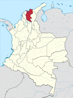
Magdalena Department
Department of Colombia
Distance: Approx. 5406 meters
Latitude and longitude: 11.24194444,-74.20527778
Magdalena (Spanish pronunciation: [maɣðaˈlena]) is a department of Colombia with more than 1.3 million people, located to the north of the country by the Caribbean Sea. The capital of the Magdalena Department is Santa Marta and was named after the Magdalena River. It inherited the name of one of the original nine states of the United States of Colombia that its current territory integrated.

Santa Marta
District and city in Caribbean Region, Colombia
Distance: Approx. 5406 meters
Latitude and longitude: 11.24194444,-74.20527778
Santa Marta (Spanish pronunciation: [ˌsanta ˈmaɾta]), officially the Distrito Turístico, Cultural e Histórico de Santa Marta (English: Historic, Cultural & Tourist District of Santa Marta), is a port city on the coast of the Caribbean Sea in northern Colombia. It is the capital of Magdalena Department and the fourth-largest urban city of the Caribbean Region of Colombia, after Barranquilla, Cartagena, and Soledad. Founded on July 29, 1525, by the Spanish conqueror Rodrigo de Bastidas, it was one of the first Spanish settlements in Colombia, its oldest surviving city, and second oldest in South America.

Gaira
Town on the Caribbean coast of Colombia
Distance: Approx. 6627 meters
Latitude and longitude: 11.183,-74.217
Gaira is a small town on the Caribbean coast of Colombia. Near the port of Santa Marta, it is also well known for El Rodadero, one of the most popular beaches in Colombia.

Action of August 1702
Naval battle off coast of Colombia
Distance: Approx. 5141 meters
Latitude and longitude: 11.23805556,-74.205
The action of August 1702 was an inconclusive naval battle that took place from 19 to 25 August 1702 O.S. between an English squadron under Vice-Admiral John Benbow and a French under Admiral Jean du Casse, off Cape Santa Marta on the coast of present-day Colombia, South America, during the War of the Spanish Succession. Benbow vigorously attacked the French squadron, but the refusal of most of his captains to support the action allowed du Casse to escape. Benbow lost a leg during the engagement and died of illness about two months later.

Estadio Eduardo Santos
Multi-use stadium in Santa Marta, Colombia
Distance: Approx. 4391 meters
Latitude and longitude: 11.2398262,-74.1951263
Estadio Eduardo Santos is a multi-use stadium in Santa Marta, Colombia, used mostly for football matches. It is the largest sports facility in Magdalena Department with a maximum capacity of 23,000 people. The stadium is named after politician and publisher Eduardo Santos, President of the Republic of Colombia from 1938 to 1942.

Quinta de San Pedro Alejandrino
Estate in Colombia
Distance: Approx. 2224 meters
Latitude and longitude: 11.22805556,-74.17916667
The Quinta de San Pedro Alejandrino (English: Quinta of Saint Peter of Alexandria) is an hacienda or quinta built in 1608, famous for being the death place of Simón Bolívar on December 17, 1830. The hacienda is located in the corregimiento of Mamatoco within the tourist district of Santa Marta, near the Caribbean Sea in northern Colombia.
University of Magdalena
Distance: Approx. 2472 meters
Latitude and longitude: 11.2215,-74.1862
The University of Magdalena (Spanish: Universidad del Magdalena), is a public, departmental, coeducational, research university based in the city of Santa Marta, Magdalena, Colombia. It received high quality institutional accreditation from the Ministry of National Education on August 26, 2016, for a period of four years, being the second public university in the region to receive such accreditation.

Rodadero Sea Aquarium and Museum
Zoo in Magdalena, Colombia
Distance: Approx. 7887 meters
Latitude and longitude: 11.216969,-74.237151
The Rodadero Sea Aquarium and Museum (Spanish: Acuario y Museo del Mar del Rodadero) is a public aquarium and maritime museum located in the Inca Inca Cove off the Rodadero beach in Santa Marta, Colombia. It was opened in 1965 by Captain Francisco Ospina Navia. The aquarium is part of the National Network of Museums of Colombia and part of ACOPAZOA, the Colombian branch of the World Association of Zoos and Aquariums.

Estadio Sierra Nevada
Football stadium in Colombia
Distance: Approx. 4521 meters
Latitude and longitude: 11.1908847,-74.19924611
Estadio Sierra Nevada (Spanish: Estadio Sierra Nevada [esˈtaðjo ˈsjera neˈβaða]) (also known as Estadio Unidad Bolivariana Bureche) is a football stadium in the city of Santa Marta, Colombia. The stadium was opened on 11 November 2017. It was the host stadium for the football matches at the 2017 Bolivarian Games and home stadium for local football club Unión Magdalena starting from 2018.

Casa de la Aduana
Colonial building in Santa Marta, Colombia
Distance: Approx. 6329 meters
Latitude and longitude: 11.24533333,-74.21316667
Casa de la Aduana (which means Customs House in Spanish; also known as the Tayrona Gold Museum) is a colonial building located in the Plaza de Bolívar in the city of Santa Marta, Magdalena. It is the regional headquarters of the Gold Museum, which is part of the Bank of the Republic of Colombia. This museum offers the visitor a vision of the goldsmithing and the culture of the ancient inhabitants of the Sierra Nevada.

Santa Marta Bay
Distance: Approx. 6628 meters
Latitude and longitude: 11.24111111,-74.21888889
Santa Marta Bay (Spanish: Bahía de Santa Marta) is a bay located in the Caribbean Sea, in northern Magdalena Department of Colombia. Its waters bathe the city of Santa Marta, the country's second port in the Caribbean. In the vicinity of the bay is the Sierra Nevada de Santa Marta, which is the highest intertropical mountain in the world by the sea.
Weather in this IP's area
overcast clouds
29 Celsius
34 Celsius
29 Celsius
29 Celsius
1011 hPa
76 %
1011 hPa
1007 hPa
10000 meters
1.07 m/s
1.89 m/s
157 degree
99 %
05:46:14
17:36:10