190.109.219.79 - IP Lookup: Free IP Address Lookup, Postal Code Lookup, IP Location Lookup, IP ASN, Public IP
Country:
 Honduras
Region:
City:
Location:
Time Zone:
Postal Code:
ISP:
ASN:
language:
User-Agent:
Proxy IP:
Blacklist:
IP information under different IP Channel
ip-api
Country
Region
City
ASN
Time Zone
ISP
Blacklist
Proxy
Latitude
Longitude
Postal
Route
db-ip
Country
Region
City
ASN
Time Zone
ISP
Blacklist
Proxy
Latitude
Longitude
Postal
Route
IPinfo
Country
Region
City
ASN
Time Zone
ISP
Blacklist
Proxy
Latitude
Longitude
Postal
Route
IP2Location
190.109.219.79Country
hnRegion
la paz
City
yarumela
Time Zone
America/Tegucigalpa
ISP
Language
User-Agent
Latitude
Longitude
Postal
ipdata
Country
Region
City
ASN
Time Zone
ISP
Blacklist
Proxy
Latitude
Longitude
Postal
Route
Popular places and events near this IP address

Operation Golden Pheasant
1988 deployment of US troops in Honduras
Distance: Approx. 6668 meters
Latitude and longitude: 14.392,-87.621
Operation Golden Pheasant was an emergency deployment of U.S. troops to Honduras in 1988, in response to Nicaraguan attacks on Contra logistics in Honduras.
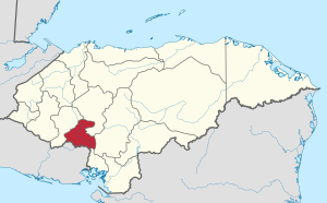
La Paz Department (Honduras)
Department in Honduras
Distance: Approx. 5396 meters
Latitude and longitude: 14.33333333,-87.68333333
La Paz (Spanish pronunciation: [la pas]) is one of the 18 political and geographic departments of Honduras. The departmental capital is the city of La Paz. The department covers a total surface area of 2,331 km².
La Paz, Honduras
Municipality in La Paz, Honduras
Distance: Approx. 5659 meters
Latitude and longitude: 14.317,-87.683
La Paz (Spanish pronunciation: [la ˈpas]) is the capital city of the La Paz Department of Honduras. The town, founded in 1792, has a population of 32,450 (2023 est.). La Paz is located 750m (2461 feet) above sea level on the Comayagua River near the Cordillera de Montecillos in an area that has mountainous terrain with thick jungle cover.
Ajuterique
Municipality in Comayagua, Honduras
Distance: Approx. 9097 meters
Latitude and longitude: 14.38333333,-87.7
Ajuterique is a municipality in the Honduran department of Comayagua.

San Sebastián, Comayagua
Municipality in Comayagua, Honduras
Distance: Approx. 9273 meters
Latitude and longitude: 14.25,-87.63333333
San Sebastián is a municipality in the Honduran department of Comayagua.
Villa de San Antonio
Municipality in Comayagua, Honduras
Distance: Approx. 2578 meters
Latitude and longitude: 14.31666667,-87.61666667
Villa de San Antonio is a municipality in the Honduran department of Comayagua. The municipality consists of a casco urbano (main town), with approximately 7,000 residents, and a large number of 'aldeas' or villages, which bring the municipality's entire population to 17,000. The town is located 20 minutes by car from the department capitals of Comayagua and La Paz, and 90 minutes from Tegucigalpa.
Lejamaní
Municipality in Comayagua, Honduras
Distance: Approx. 8096 meters
Latitude and longitude: 14.36666667,-87.7
Lejamaní is one of the 21 municipalities in the Honduran department of Comayagua.
Cane, La Paz
Municipality in La Paz, Honduras
Distance: Approx. 6625 meters
Latitude and longitude: 14.28333333,-87.66666667
Cane is a municipality in the Honduran department of La Paz. The population of Cane is not exact, but is estimated to be around 4,000. The current mayor is Jose Tejeda, who is very popular among the community, as he has donated millions of US dollars to the creation of a lush central park stocked with trash cans, benches, and a taco bar.
Marcala
Municipality in La Paz, Honduras
Distance: Approx. 5659 meters
Latitude and longitude: 14.317,-87.683
Marcala is a town, with a population of 15,050 (2023 calculation), and a municipality in the Honduran department of La Paz. The region is known for its coffee production, boasting the first "protected origin denomination" for coffee. Marcala has been designated as a center of Lenca Trail, a government and United Nations sponsored development effort to encourage tourism to Lenca communities.
Soto Cano Air Base
Honduran military base
Distance: Approx. 5632 meters
Latitude and longitude: 14.3825,-87.62111111
Soto Cano Air Base is a Honduran military base 5 mi (8.0 km) to the south of Comayagua in Honduras. It houses 1,200–1,500 U.S. troops and is also used by the Honduran Air Force academy. The airbase became operational in 1940, changing the old location of the Honduras Air Force Academy in Toncontin, Tegucigalpa to Palmerola.
Estadio Roberto Suazo Córdova
Stadium in La Paz, Honduras
Distance: Approx. 4252 meters
Latitude and longitude: 14.321416,-87.670764
Estadio Roberto Suazo Córdova is a multi-use stadium in La Paz, Honduras. It is currently used mostly for football matches and is the home of Municipal Paceño F.C. Has the capacity for 25,000 people. Its considered as one of the biggest stadiums in Honduras.

Comayagua International Airport
Airport serving Tegucigalpa, Honduras
Distance: Approx. 5632 meters
Latitude and longitude: 14.3825,-87.62111111
Comayagua International Airport (IATA: XPL, ICAO: MHPR), also known as Palmerola International Airport, is an international airport located 6 km (4 mi) south of the centre of Comayagua, Honduras. The airport was inaugurated in October 2021 as the country's new international airport for civil and commercial use. It was built at the facilities of the Soto Cano Air Base.
Weather in this IP's area
overcast clouds
28 Celsius
28 Celsius
28 Celsius
28 Celsius
1013 hPa
50 %
1013 hPa
888 hPa
10000 meters
2.95 m/s
4.17 m/s
19 degree
100 %