190.108.26.84 - IP Lookup: Free IP Address Lookup, Postal Code Lookup, IP Location Lookup, IP ASN, Public IP
Country:
 Uruguay
Region:
City:
Location:
Time Zone:
Postal Code:
ISP:
ASN:
language:
User-Agent:
Proxy IP:
Blacklist:
IP information under different IP Channel
ip-api
Country
Region
City
ASN
Time Zone
ISP
Blacklist
Proxy
Latitude
Longitude
Postal
Route
db-ip
Country
Region
City
ASN
Time Zone
ISP
Blacklist
Proxy
Latitude
Longitude
Postal
Route
IPinfo
Country
Region
City
ASN
Time Zone
ISP
Blacklist
Proxy
Latitude
Longitude
Postal
Route
IP2Location
190.108.26.84Country
uyRegion
maldonado
City
buenos aires
Time Zone
America/Montevideo
ISP
Language
User-Agent
Latitude
Longitude
Postal
ipdata
Country
Region
City
ASN
Time Zone
ISP
Blacklist
Proxy
Latitude
Longitude
Postal
Route
Popular places and events near this IP address

HMS Agamemnon (1781)
18th-century British Royal Navy ship of the line
Distance: Approx. 3560 meters
Latitude and longitude: -34.93305556,-54.98111111
HMS Agamemnon was a 64-gun third-rate ship of the line of the British Royal Navy. She saw service in the American Revolutionary War, French Revolutionary, and Napoleonic Wars and fought in many major naval battles. She is remembered as Horatio Nelson's favourite ship, and she was named after the mythical ancient Greek king Agamemnon, the first ship of the Royal Navy to bear the name.

Punta del Este
Uruguayan seaside resort city
Distance: Approx. 3047 meters
Latitude and longitude: -34.96666667,-54.95
Punta del Este (Spanish pronunciation: [ˈpunta ðel ˈeste]) is a seaside city and peninsula on the Atlantic Coast in the Maldonado Department of southeastern Uruguay. Starting as a small town, Punta del Este grew to become a resort for the Latin and North American jet set and tourists. The city has been called "The Monaco of the South", "The Pearl of the Atlantic", "The Hamptons of South America", "The Miami Beach of South America", or "The St.

Estadio Domingo Burgueño
Multi-use stadium in Maldonado, Uruguay
Distance: Approx. 3047 meters
Latitude and longitude: -34.91444444,-54.95527778
Estadio Domingo Burgueño is a multi-use stadium in Maldonado, Uruguay. It is used mostly for football matches. The stadium holds 22,000 people and was built in 1994.
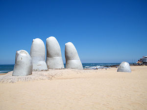
La Mano de Punta del Este
Sculpture in Uruguay
Distance: Approx. 2069 meters
Latitude and longitude: -34.95786389,-54.93718056
La Mano (The Hand) is a sculpture in Punta del Este by Chilean artist Mario Irarrázabal. It depicts five human fingers partially emerging from sand and is located on Parada 1 at Brava Beach in Punta del Este, a popular tourist town in Uruguay. It is also known as either Los Dedos (The Fingers), or Hombre emergiendo a la vida (Man Emerging into Life).

Pinares – Las Delicias
Resort and suburb of Maldonado in Maldonado Department, Uruguay
Distance: Approx. 3406 meters
Latitude and longitude: -34.91722222,-54.96805556
Pinares – Las Delicias is a resort (balneario) and southwestern urban extension of the capital of Maldonado Department of Uruguay.
Ajdut Israel Synagogue
Orthodox synagogue in Punta del Este, Uruguay
Distance: Approx. 834 meters
Latitude and longitude: -34.93355501,-54.94786382
The Ajdut Israel Synagogue (Spanish: Sinagoga Ajdut Israel) is an Hasidic Jewish synagogue, located in Punta del Este, in the Maldonado Department, of southeastern Uruguay. The synagogue is administered by Beit Jabad, a Chabad organisation.
Templo Rafael, Punta del Este
Synagogue in Punta del Este, Uruguay
Distance: Approx. 3165 meters
Latitude and longitude: -34.9672,-54.9527
The Rafael Temple (Spanish: Templo Rafael) is a Jewish congregation and synagogue, located on Capitán Miranda Street (calle 7), in Punta del Este, in the Maldonado Department, of southeastern Uruguay. It is the oldest synagogue in Punta del Este.
Beit Yaacov Synagogue, Punta del Este
Synagogue in Punta del Este, Uruguay
Distance: Approx. 1939 meters
Latitude and longitude: -34.95707176,-54.93946719
The Beit Yaacov Synagogue (Spanish: Sinagoga Beit Yaacov) is a Jewish congregation and synagogue, located on Calle Riso, in Punta del Este, in the Maldonado Department, of southeastern Uruguay. The synagogue, with a central location, is mostly attended by Sephardi Jews.

Nuestra Señora de la Candelaria, Punta del Este
Distance: Approx. 3295 meters
Latitude and longitude: -34.96888889,-54.95027778
The Church of Our Lady of Candelaria (Spanish: Iglesia de Nuestra Señora de la Candelaria) is a Roman Catholic parish church in Punta del Este, Uruguay. The parish was established 1 February 1948. The first temple was built in 1911.

Gorriti Island
Distance: Approx. 2968 meters
Latitude and longitude: -34.9525,-54.97166667
Gorriti Island (Spanish: Isla Gorriti) is a small island near the shores of Punta del Este, Uruguay.
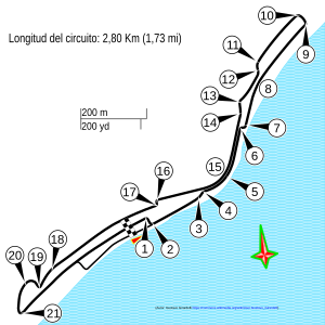
Punta del Este Street Circuit
Distance: Approx. 1825 meters
Latitude and longitude: -34.95472222,-54.93444444
Punta del Este Street Circuit was a street circuit located in Punta del Este, Uruguay. It ran along the town's harbour – nicknamed the Monte Carlo of South America. The Argentine TC2000 Championship hosted three races at Punta del Este in 2007, 2008 and 2010.

Trump Tower Punta del Este
Apartments in Punta del Este, Uruguay
Distance: Approx. 1971 meters
Latitude and longitude: -34.94611111,-54.92277778
Trump Tower Punta del Este is a 26-story luxury apartment tower in Punta del Este, Uruguay. The project was announced in November 2012, and YY Development Group began construction in January 2014. The tower is named after Donald Trump, and was overseen by his son, Eric Trump.
Weather in this IP's area
clear sky
22 Celsius
23 Celsius
22 Celsius
24 Celsius
1008 hPa
90 %
1008 hPa
1008 hPa
10000 meters
4.63 m/s
40 degree