190.107.27.52 - IP Lookup: Free IP Address Lookup, Postal Code Lookup, IP Location Lookup, IP ASN, Public IP
Country:
Region:
City:
Location:
Time Zone:
Postal Code:
IP information under different IP Channel
ip-api
Country
Region
City
ASN
Time Zone
ISP
Blacklist
Proxy
Latitude
Longitude
Postal
Route
Luminati
Country
Region
ant
City
medellin
ASN
Time Zone
America/Bogota
ISP
Media Commerce Partners S.A
Latitude
Longitude
Postal
IPinfo
Country
Region
City
ASN
Time Zone
ISP
Blacklist
Proxy
Latitude
Longitude
Postal
Route
IP2Location
190.107.27.52Country
Region
boyaca
City
tunja
Time Zone
America/Bogota
ISP
Language
User-Agent
Latitude
Longitude
Postal
db-ip
Country
Region
City
ASN
Time Zone
ISP
Blacklist
Proxy
Latitude
Longitude
Postal
Route
ipdata
Country
Region
City
ASN
Time Zone
ISP
Blacklist
Proxy
Latitude
Longitude
Postal
Route
Popular places and events near this IP address

Boyacá Department
Department of Colombia
Distance: Approx. 277 meters
Latitude and longitude: 5.53333333,-73.36666667
Boyacá (Spanish pronunciation: [boʝaˈka]) is one of the thirty-two departments of Colombia, and the remnant of Boyacá State, one of the original nine states of the "United States of Colombia". Boyacá is centrally located within Colombia, almost entirely within the mountains of the Eastern Cordillera to the border with Venezuela, although the western end of the department extends to the Magdalena River at the town of Puerto Boyacá. Boyacá borders to the north with the Department of Santander, to the northeast with the Bolivarian Republic of Venezuela and Norte de Santander, to the east with the departments of Arauca and Casanare.

Tunja
Municipality and city in Boyacá, Colombia
Distance: Approx. 277 meters
Latitude and longitude: 5.53333333,-73.36666667
Tunja (Spanish pronunciation: [ˈtuŋxa]) is a municipality and city on the Eastern Ranges of the Colombian Andes, in the region known as the Altiplano Cundiboyacense, 130 km northeast of Bogotá. In 2018 the municipality had a population of 172,548. It is the capital of Boyacá department and the Central Boyacá Province.

Estadio La Independencia
Stadium in Tunja, Colombia
Distance: Approx. 1839 meters
Latitude and longitude: 5.54223333,-73.35313056
Estadio La Independencia (Spanish for The Independence Stadium) is a multi-use stadium in the city of Tunja, Colombia. It is currently used mostly for football matches. The stadium has a capacity of 25,000 people, and is 2,800 metres above sea level.
Central Boyacá Province
Province in Boyacá, Colombia
Distance: Approx. 277 meters
Latitude and longitude: 5.53333333,-73.36666667
The Central Boyacá Province (Spanish: Provincia de Centro de Boyacá) is a province of the Colombian Department of Boyacá. The province is formed by fifteen municipalities, including the departmental capital Tunja.

Roman Catholic Archdiocese of Tunja
Catholic archdiocese in Colombia
Distance: Approx. 843 meters
Latitude and longitude: 5.5321,-73.3613
The Roman Catholic Archdiocese of Tunja (Latin: Tunquensis) is an archdiocese located in the city of Tunja in Colombia.

Boyacá State
Distance: Approx. 277 meters
Latitude and longitude: 5.53333333,-73.36666667
Boyacá State was one of the states of Colombia, which existed from 1857 until 1886.

Tunja Province
Distance: Approx. 277 meters
Latitude and longitude: 5.53333333,-73.36666667
Tunja Province was one of the provinces of Gran Colombia. It belonged to the Boyacá Department which was created in 1824.
Cojines del Zaque
Archeological site in Colombia
Distance: Approx. 345 meters
Latitude and longitude: 5.53815833,-73.36941111
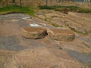
The Cojines del Zaque (English: "Cushions of the Zaque") is an archeological site of the Muisca located in the city of Tunja, Boyacá, which in the time of the Muisca Confederation was called Hunza. The cojines are two round stones used in the religion of the Muisca to worship Sun god Sué and his wife; Moon goddess Chía. When the Spanish conquistadores arrived, they called them Cojines del Diablo.

Cathedral Basilica of St. James the Apostle, Tunja
Church in Tunja, Colombia
Distance: Approx. 788 meters
Latitude and longitude: 5.5336,-73.3613
The Cathedral Basilica of St. James the Apostle (Spanish: Catedral Basílica de Santiago Apóstol) also called Tunja Cathedral It is the oldest Roman Catholic cathedral of Colombia, which is enshrined under the patronage of St. James the Greater (Santiago Apóstol).

Casa del Fundador Gonzalo Suárez Rendón
Museum and monument in Boyacá, Colombia
Distance: Approx. 613 meters
Latitude and longitude: 5.53222222,-73.36361111
The Casa del Fundador Gonzalo Suárez Rendón (English: "House of the Founder Gonzalo Suárez Rendón") is a museum and monument in Tunja, the capital of Boyacá, Colombia. It is situated on the central square of Tunja, named Plaza Bolívar, but historically called Plaza Suárez Rendón, honouring the city founder Gonzalo Suárez Rendón, who established Tunja for the Spanish Crown on August 6, 1539. The colonial building, declared a monument in 1959 and designated as museum in 1965, is the only remaining house of a city founder in Latin America and started construction in 1540.

Central Cemetery of Tunja
Cemetery in Boyacá Department, Colombia
Distance: Approx. 1256 meters
Latitude and longitude: 5.5393,-73.3576
The Central Cemetery of Tunja (Spanish: Cementerio Central de Tunja) is the most important cemetery in the city of Tunja, in Boyacá, Colombia, and considered one of the oldest in the country.

House of Juan Agustín Niño y Álvarez
Distance: Approx. 730 meters
Latitude and longitude: 5.53233,-73.36233
The House of Juan Agustín Niño y Álvarez is a building located in Tunja, Colombia, towards the southwest direction of Plaza de Bolívar. This house has been declared an Asset of Cultural Interest. Currently, it is being used as the Secretariat of Culture and Heritage, as well as the Secretariat of Tourism of the Government of Boyacá.
Weather in this IP's area
overcast clouds
11 Celsius
10 Celsius
11 Celsius
11 Celsius
1016 hPa
94 %
1016 hPa
735 hPa
10000 meters
0.39 m/s
0.6 m/s
340 degree
100 %

