190.107.22.167 - IP Lookup: Free IP Address Lookup, Postal Code Lookup, IP Location Lookup, IP ASN, Public IP
Country:
Region:
City:
Location:
Time Zone:
Postal Code:
IP information under different IP Channel
ip-api
Country
Region
City
ASN
Time Zone
ISP
Blacklist
Proxy
Latitude
Longitude
Postal
Route
Luminati
Country
Region
ant
City
medellin
ASN
Time Zone
America/Bogota
ISP
Media Commerce Partners S.A
Latitude
Longitude
Postal
IPinfo
Country
Region
City
ASN
Time Zone
ISP
Blacklist
Proxy
Latitude
Longitude
Postal
Route
IP2Location
190.107.22.167Country
Region
cauca
City
popayan
Time Zone
America/Bogota
ISP
Language
User-Agent
Latitude
Longitude
Postal
db-ip
Country
Region
City
ASN
Time Zone
ISP
Blacklist
Proxy
Latitude
Longitude
Postal
Route
ipdata
Country
Region
City
ASN
Time Zone
ISP
Blacklist
Proxy
Latitude
Longitude
Postal
Route
Popular places and events near this IP address
Cauca Department
Department of Colombia
Distance: Approx. 1352 meters
Latitude and longitude: 2.45,-76.61666667
Cauca Department (Spanish pronunciation: [ˈkawka], Spanish: Departamento del Cauca) is a department of Southwestern Colombia. Located in the southwestern part of the country, facing the Pacific Ocean to the west, the Valle del Cauca Department to the north, Tolima Department to the northeast, Huila Department to the east, and Nariño Department to the south. Putumayo and Caqueta Departments border the southeast portion of Cauca Department as well.

Popayán
City in Cauca, Colombia
Distance: Approx. 1828 meters
Latitude and longitude: 2.45416667,-76.60916667
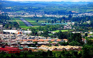
Popayán (Spanish pronunciation: [popaˈʝan] ) is the capital of the Colombian department of Cauca. It is located in the Pubenza Valley in southwestern Colombia between the Western Mountain Range and Central Mountain Range. The municipality has a population of 318,059, an area of 483 km2, is located 1760 meters above sea level, and has an average temperature of 18 °C. The town is well known for its colonial architecture and its contributions to Colombian cultural and political life.

Morro del Tulcán
Pyramid in Colombia
Distance: Approx. 1640 meters
Latitude and longitude: 2.44444444,-76.6
El Morro del Tulcán (lit. Tulcán Hill) is an Indigenous pyramid in Popayán, Colombia. The pyramid was constructed in the pre-Columbian period, approximately between 1600–500 BCE; the period which is now known as "Late Chieftain Societies".

Guillermo León Valencia Airport
Airport
Distance: Approx. 1813 meters
Latitude and longitude: 2.45416667,-76.60972222
Guillermo León Valencia Airport (Spanish: Aeropuerto Guillermo León Valencia) (IATA: PPN, ICAO: SKPP) is an airport serving Popayán, the capital city of the Cauca Department in Colombia. It took the name of former President of Colombia Guillermo León Valencia Muñoz.

Roman Catholic Archdiocese of Popayán
Catholic archdiocese in Colombia
Distance: Approx. 828 meters
Latitude and longitude: 2.4411,-76.6065
The Roman Catholic Archdiocese of Popayán (Latin: Popayanensis) is an archdiocese located in the city of Popayán in Colombia.

University of Cauca
University in Colombia
Distance: Approx. 1005 meters
Latitude and longitude: 2.44083333,-76.60472222
The University of Cauca (Spanish: Universidad del Cauca) is a public research university located in the city of Popayán, capital of the department of Cauca, Colombia. It was created on April 24, 1827, by a decree by the President Francisco de Paula Santander. It was installed on November 11, 1827 and the nationalization was ratified by Law 65 of 1964.

Popayán Province
Distance: Approx. 1352 meters
Latitude and longitude: 2.45,-76.61666667
Popayán Province was first a Spanish jurisdiction under the Royal Audience of Quito and the Royal Audience of Santafé, and after independence, was one of the provinces of the Cauca Department (Gran Colombia), later becoming the Republic of New Granada.

Cauca State
Distance: Approx. 1353 meters
Latitude and longitude: 2.45,-76.6167
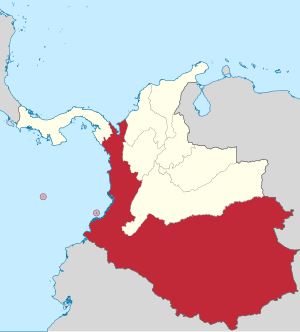
Cauca State was one of the states of Colombia, which existed from 1857 until 1886. Today the area of the former state makes up most of modern-day west and southern Colombia, with some portion of its vast territories acquired by present-day Peru, Brazil, Ecuador and Venezuela.
1983 Popayán earthquake
Natural disaster in Colombia
Distance: Approx. 8461 meters
Latitude and longitude: 2.461,-76.686
The 1983 Popayán earthquake (Spanish: El Terremoto de Popayán) occurred on 31 March in Popayán, Colombia. It had a moment magnitude of 5.6 with an epicenter south west of Popayán at a depth of 15 kilometers (9.3 mi). The earthquake killed 267 people and resulted in the passing of new laws requiring earthquake resistant building materials in zones at risk of tremors.

Cathedral Basilica of Our Lady of the Assumption, Popayán
Church in Popayán, Colombia
Distance: Approx. 841 meters
Latitude and longitude: 2.4414,-76.6065
The Cathedral Basilica of Our Lady of the Assumption (Spanish: Catedral Basílica de Nuestra Señora de la Asunción) also called Popayán Cathedral It is a Catholic cathedral dedicated to the Virgin Mary under the title of Our Lady of the Assumption of Popayán.

Estadio Ciro López
Football stadium located in Popayán, Colombia
Distance: Approx. 3012 meters
Latitude and longitude: 2.45444444,-76.59166667
Estadio Ciro López is a football stadium located in Popayán, Colombia. The stadium was opened on 8 July 1951 with a match between the Cauca Department football team and Millonarios, who were at the time known as the Ballet Azul (Blue Ballet).

Popayán Archdiocesan Museum of Religious Art
Religious Art Museum in Popayán, Colombia
Distance: Approx. 1076 meters
Latitude and longitude: 2.441819,-76.604386
The Popayán Archdiocesan Museum of Religious Art (Spanish: Museo de Arte Religioso Arquidiocesano de Popayán) is a museum located in the capital of the department of Cauca, Colombia. The museum is mainly dedicated to exhibit sacred art.
Weather in this IP's area
moderate rain
17 Celsius
18 Celsius
17 Celsius
17 Celsius
1012 hPa
97 %
1012 hPa
829 hPa
5904 meters
0.4 m/s
1.04 m/s
312 degree
96 %
