190.102.121.132 - IP Lookup: Free IP Address Lookup, Postal Code Lookup, IP Location Lookup, IP ASN, Public IP
Country:
 Colombia
Region:
City:
Location:
Time Zone:
Postal Code:
ISP:
ASN:
language:
User-Agent:
Proxy IP:
Blacklist:
IP information under different IP Channel
ip-api
Country
Region
City
ASN
Time Zone
ISP
Blacklist
Proxy
Latitude
Longitude
Postal
Route
db-ip
Country
Region
City
ASN
Time Zone
ISP
Blacklist
Proxy
Latitude
Longitude
Postal
Route
IPinfo
Country
Region
City
ASN
Time Zone
ISP
Blacklist
Proxy
Latitude
Longitude
Postal
Route
IP2Location
190.102.121.132Country
coRegion
cundinamarca
City
fusagasuga
Time Zone
America/Bogota
ISP
Language
User-Agent
Latitude
Longitude
Postal
ipdata
Country
Region
City
ASN
Time Zone
ISP
Blacklist
Proxy
Latitude
Longitude
Postal
Route
Popular places and events near this IP address

Pasca
Town and municipality in Cundinamarca, Colombia
Distance: Approx. 7680 meters
Latitude and longitude: 4.3075,-74.30083333
Pasca is a town and municipality in the Cundinamarca department of Colombia located in the Andes. It belongs to the Sumapaz Province. Pasca is situated on the Altiplano Cundiboyacense at a distance of 71 kilometres (44 mi) from the capital Bogotá.

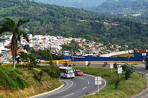
Fusagasugá
Municipality and city in Andean Region, Colombia
Distance: Approx. 1007 meters
Latitude and longitude: 4.34515278,-74.36182222
Fusagasugá (Spanish pronunciation: [fusaɣasuˈɣa]; from Cariban fusagasuga 'woman who becomes invisible') or Fusa is a city and municipality in the department of Cundinamarca, in central Colombia. It is located in the warm valley between the rivers Cuja and Panches, a central region of the Andes Mountains in South America. The municipality has a population of 138,498 and the urban centre a population of 114,722 (2018 census) .
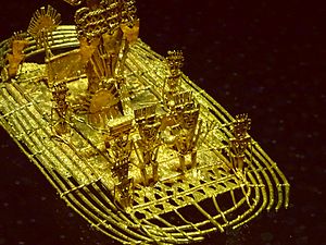
Archaeology Museum, Pasca
Distance: Approx. 7723 meters
Latitude and longitude: 4.30883333,-74.29980556
The Archaeology Museum of Pasca (Spanish: Museo Arqueológico de Pasca) is an archaeological museum located in Pasca, Colombia. It houses a great collection of Pre-Columbian objects and human remains, including Muisca mummies. It has a replica of the famous golden raft, Balsa Muisca, found near this town that represents the El Dorado rite.
Silvania, Colombia
Municipality and town in Cundinamarca, Colombia
Distance: Approx. 7937 meters
Latitude and longitude: 4.40333333,-74.38805556
Silvania is a town and municipality in Cundinamarca Department, Colombia.
Arbeláez
Municipality and town in Cundinamarca, Colombia
Distance: Approx. 9109 meters
Latitude and longitude: 4.27254,-74.41513
Arbeláez (Spanish pronunciation: [aɾβeˈlaes]) is a town and municipality in the Cundinamarca Department, Colombia. It borders Fusagasugá, Pasca and other municipalities of the Sumapaz Province. Arbeláez is recognized as a quiet and friendly city of Colombia.

Estadio Fernando Mazuera
Distance: Approx. 271 meters
Latitude and longitude: 4.33408333,-74.36269444
Estadio Fernando Mazuera is a multi-use stadium in Fusagasugá, Colombia. It is currently used mostly for football matches and is the home stadium of Expreso Rojo. The stadium holds 4,500 people.

Tibacuy
Municipality and town in Cundinamarca, Colombia
Distance: Approx. 9932 meters
Latitude and longitude: 4.34722222,-74.4525
Tibacuy is a municipality and town of Colombia in the department of Cundinamarca, in Sumapaz Province. Tibacuy is situated south of the Altiplano Cundiboyacense in the Eastern Ranges of the Colombian Andes at 87 kilometres (54 mi) southeast of the capital Bogotá.

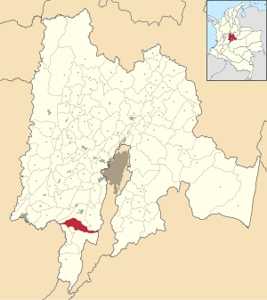
Sumapaz Province
Province in Cundinamarca, Colombia
Distance: Approx. 132 meters
Latitude and longitude: 4.33722222,-74.36444444
Sumapaz Province is one of the 15 provinces in the Cundinamarca Department, Colombia.

Battle of Pasca
Distance: Approx. 7680 meters
Latitude and longitude: 4.3075,-74.30083333
The Battle of Pasca was fought between the southern Muisca Confederation, led by their zipa (ruler), Saguamanchica, and an alliance between the Panche and the Sutagao, led by the Cacique of Fusagasugá. The battle took place c. 1470 in the vicinity of Pasca, in modern-day Cundinamarca, Colombia, and resulted in a victory for Saguamanchica.
Weather in this IP's area
broken clouds
24 Celsius
24 Celsius
24 Celsius
24 Celsius
1011 hPa
64 %
1011 hPa
791 hPa
10000 meters
2.93 m/s
1.78 m/s
300 degree
55 %