Country:
 Chile
ChileRegion:
City:
Latitude and Longitude:
Time Zone:
Postal Code:
IP information under different IP Channel
ip-api
Country
Region
City
ASN
Time Zone
ISP
Blacklist
Proxy
Latitude
Longitude
Postal
Route
IPinfo
Country
Region
City
ASN
Time Zone
ISP
Blacklist
Proxy
Latitude
Longitude
Postal
Route
MaxMind
Country
Region
City
ASN
Time Zone
ISP
Blacklist
Proxy
Latitude
Longitude
Postal
Route
Luminati
Country
CLRegion
rm
City
sanmiguel
ASN
Time Zone
America/Santiago
ISP
VTR BANDA ANCHA S.A.
Latitude
Longitude
Postal
db-ip
Country
Region
City
ASN
Time Zone
ISP
Blacklist
Proxy
Latitude
Longitude
Postal
Route
ipdata
Country
Region
City
ASN
Time Zone
ISP
Blacklist
Proxy
Latitude
Longitude
Postal
Route
Popular places and events near this IP address

Universidad Central de Chile
University in Chile
Distance: Approx. 1192 meters
Latitude and longitude: -33.45305556,-70.66027778
Universidad Central de Chile (English: Central University of Chile), abbreviated as UCEN, is the first autonomous private university in Chile, founded in 1982 in Santiago de Chile. It's accredited in the areas of institutional management and undergraduate teaching by the National Accreditation Commission of Chile for a term of four years from December 2017 to December 2021. The Universidad Central de Chile is structured in five faculties in which are held 33 undergraduate programs and an institute that imparts 6 top-level technical careers.

Basílica de los Sacramentinos
Distance: Approx. 625 meters
Latitude and longitude: -33.45131944,-70.64905278
The Basílica de los Sacramentinos is a church in the Roman Catholic Archdiocese of Santiago de Chile. It administered by the Congregation of the Blessed Sacrament and its design was inspired by the Basilique du Sacré-Cœur in Paris. The main cupola of the church has a structural height of 69 m (226 ft).
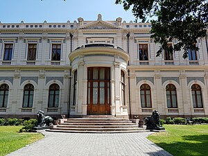
Palacio Cousiño
Distance: Approx. 933 meters
Latitude and longitude: -33.45219167,-70.65661111
The Palacio Cousiño is a palace that was designed and built for Isidora Goyenechea, widow of Luis Cousiño, who in turn was son of Matías Cousiño. It is located at 438 Dieciocho Street in Santiago, Chile. The palace was designed by architect Paul Lathoud, who also designed the building housing the Chilean National Museum of Natural History.
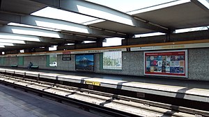
Parque O'Higgins metro station
Santiago metro station
Distance: Approx. 948 meters
Latitude and longitude: -33.46164722,-70.65677222
Parque O'Higgins is a metro station on the Line 2 of the Santiago Metro, in Santiago, Chile. It is located in the middle of the east branch of the Autopista Central, on a raised embankment, just prior to an elevated viaduct that crosses Matta avenue. The station is named for the adjacent Parque O'Higgins, located west of the station.
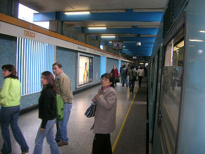
Toesca metro station
Santiago metro station
Distance: Approx. 1053 meters
Latitude and longitude: -33.45291111,-70.65858056
Toesca is a metro station on the Line 2 of the Santiago Metro, in Santiago, Chile. It is located in the middle of a sunken stretch of the Autopista Central. The station is named for the nearby Toesca Street, which in turn is named after Joaquín Toesca, who designed La Moneda Palace.
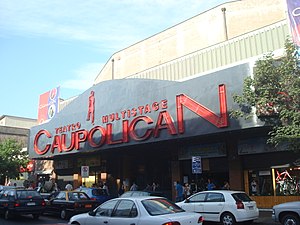
Teatro Caupolicán
Venue in Chile
Distance: Approx. 114 meters
Latitude and longitude: -33.45621667,-70.64921111
Teatro Caupolicán (Caupolicán Theatre) is a theatre and music venue located on the San Diego street in Santiago, Chile. It was opened in 1936. During its long history has hosted sporting, political, and cultural events.
Economy, Government and Communications, Central University of Chile
Public administration school of the Central University of Chile
Distance: Approx. 602 meters
Latitude and longitude: -33.45277778,-70.6525
The Faculty of Economy, Government and Communications, Central University of Chile (Spanish: Facultad de Economía, Gobierno y Comunicaciones de la Universidad Central de Chile), also known as the Faculty of Government, is one of the first School of Public Administration career in Santiago taught by a private university. The building is located in the University District of Santiago, near the Parque Almagro metro station and Paseo Bulnes.
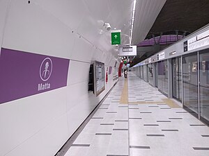
Matta metro station
Santiago metro station
Distance: Approx. 504 meters
Latitude and longitude: -33.45805556,-70.64305556
Matta is an underground metro station of Line 3 of the Santiago Metro network, in Santiago, Chile. It is an underground, between the Parque Almagro and Irarrázaval stations on Line 3. It is located at the intersection of Matta Avenue with Santa Rosa Avenue.

Parque Almagro metro station
Santiago metro station
Distance: Approx. 628 meters
Latitude and longitude: -33.45166667,-70.65083333
Parque Almagro is an underground metro station of Line 3 of the Santiago Metro network, in Santiago, Chile. It is an underground, between the Universidad de Chile and Matta stations on Line 3. It is located at the intersection of San Diego Avenue with Santa Isabel Avenue.

Parque O'Higgins Circuit
Distance: Approx. 1230 meters
Latitude and longitude: -33.4625,-70.65972222
The Parque O'Higgins Circuit was an 11 turn, 2.287 km (1.421 mi) long temporary street circuit located in the city of Santiago, Chile, and was used for the Santiago ePrix of the electric, single-seater ABB Formula E Championship. Its first use came on 26 January 2019, when it hosted the 2019 Santiago ePrix, and replaced the previous Santiago Street Circuit as the venue of the race.

Basílica del Corazón de María (Santiago de Chile)
National monument of Chile
Distance: Approx. 303 meters
Latitude and longitude: -33.45537,-70.651
The Basilica of the Heart of Mary is a Catholic Church in the city of Santiago, Chile. Built by the Claretians, it was inaugurated on 7 December 1879, being designated as a basilica in 1929 and as a National Monument of Chile on 14 January 1987.
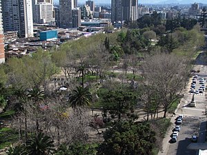
Almagro Park
Urban park in the city of Santiago, Chile
Distance: Approx. 740 meters
Latitude and longitude: -33.45194444,-70.65361111
Almagro Park is an urban park in the city of Santiago, Chile. The Basílica de los Sacramentinos is situated on the east end of the park, while the Palacio Cousiño is located on its west end. The park marks the north end of the Paseo Bulnes.
Weather in this IP's area
overcast clouds
16 Celsius
15 Celsius
16 Celsius
17 Celsius
1015 hPa
54 %
1015 hPa
952 hPa
10000 meters
0.89 m/s
1.79 m/s
270 degree
100 %
07:34:10
19:37:38