Country:
 Chile
ChileRegion:
City:
Latitude and Longitude:
Time Zone:
Postal Code:
IP information under different IP Channel
ip-api
Country
Region
City
ASN
Time Zone
ISP
Blacklist
Proxy
Latitude
Longitude
Postal
Route
IPinfo
Country
Region
City
ASN
Time Zone
ISP
Blacklist
Proxy
Latitude
Longitude
Postal
Route
MaxMind
Country
Region
City
ASN
Time Zone
ISP
Blacklist
Proxy
Latitude
Longitude
Postal
Route
Luminati
Country
CLRegion
li
City
rancagua
ASN
Time Zone
America/Santiago
ISP
VTR BANDA ANCHA S.A.
Latitude
Longitude
Postal
db-ip
Country
Region
City
ASN
Time Zone
ISP
Blacklist
Proxy
Latitude
Longitude
Postal
Route
ipdata
Country
Region
City
ASN
Time Zone
ISP
Blacklist
Proxy
Latitude
Longitude
Postal
Route
Popular places and events near this IP address

O'Higgins Region
Region of Chile
Distance: Approx. 7767 meters
Latitude and longitude: -34.16722222,-70.72694444
The Libertador General Bernardo O'Higgins Region (Spanish: Región del Libertador General Bernardo O'Higgins, pronounced [liβeɾtaˈðoɾ xeneˈɾal βeɾˈnaɾðo oˈçiɣins]), often shortened to O'Higgins Region (Spanish: Región de O'Higgins), is one of Chile's 16 first order administrative divisions. It is subdivided into three provinces. It is named in honour of Bernardo O'Higgins Riquelme, one of Chile's founding fathers.

Estadio El Teniente
Stadium in Rancagua, Chile
Distance: Approx. 8577 meters
Latitude and longitude: -34.17777778,-70.7375
Estadio El Teniente, also known as Estadio El Teniente-Codelco for sponsorship reasons, is a multi-purpose stadium in Rancagua, Chile. It is currently used mostly for football matches. The stadium can fit 14,087 people and was built in 1945 with the name Braden Copper Company Stadium (Estadio Braden Copper Co.).

Instituto O'Higgins de Rancagua
School in Rancagua, Chile
Distance: Approx. 9020 meters
Latitude and longitude: -34.1742,-70.742
Instituto O'Higgins is a private Catholic school located in the center of Rancagua, Chile. It is administered by the Marist Brothers. It was founded in 1915 by four Marist Brothers, Andrés, Donato, Cristobal and Salvador María.

Machalí
City and Commune in O'Higgins Region, Chile
Distance: Approx. 638 meters
Latitude and longitude: -34.1825,-70.65138889
Machalí is a Chilean commune and city in Cachapoal Province, O'Higgins Region.
Colegio La Cruz
High school in Cachapoal Province, Chile
Distance: Approx. 6051 meters
Latitude and longitude: -34.19534,-70.70817
Colegio La Cruz (English: La Cruz School) is a Chilean secondary school located in Machalí, Cachapoal Province, Chile.
Colegio Santa María Goretti
High school in Cachapoal Province, Chile
Distance: Approx. 8491 meters
Latitude and longitude: -34.17308,-70.73608
Colegio Santa María Goretti (English: Santa María Goretti School) is a Chilean high school located in Rancagua, Cachapoal Province, Chile.

Liceo Bicentenario Óscar Castro Zúñiga
High school
Distance: Approx. 8678 meters
Latitude and longitude: -34.171,-70.7378
Liceo Bicentenario Óscar Castro Zúñiga (English: Bicentenario Óscar Castro Zúñiga High School) is a Chilean high school located in Rancagua, Cachapoal Province, Chile.
Liceo Comercial Diego Portales
High school
Distance: Approx. 8762 meters
Latitude and longitude: -34.17645,-70.73941
Liceo Comercial Diego Portales (English: Diego Portales Commercial High School) is a Chilean high school located in Rancagua, Chile.

Liceo Industrial Presidente Pedro Aguirre Cerda
High school
Distance: Approx. 7459 meters
Latitude and longitude: -34.1691,-70.724
Liceo Industrial Presidente Pedro Aguirre Cerda (English: President Pedro Aguirre Cerda Industrial High School) is a Chilean high school located in Rancagua, Cachapoal Province, Chile.
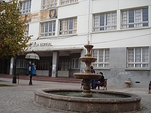
Liceo María Luisa Bombal
High school
Distance: Approx. 8982 meters
Latitude and longitude: -34.1708,-70.7411
Liceo María Luisa Bombal (English: María Luisa Bombal High School) is a Chilean high school located in Rancagua, Cachapoal Province, Chile.
Liceo Santa Cruz de Triana
High school
Distance: Approx. 6985 meters
Latitude and longitude: -34.15011,-70.70988
Liceo Técnico Santa Cruz de Triana (English: Santa Cruz de Triana Technical High School) is a Chilean high school located in Rancagua, Cachapoal Province, Chile. The high school emphasizes abilities in arts, and sports: one of its students earned a gold medal at the national tournament Juegos Bicentenario, in the category of high jump.
Colegio La República
High school in Cachapoal Province, Chile
Distance: Approx. 9092 meters
Latitude and longitude: -34.17731,-70.74307
Colegio La República (English: La República School) is a Chilean high school located in Rancagua, Cachapoal Province, Chile. As of 2012, the principal of Colegio La República is Juan Antonio Gutiérrez Espinoza. In that school year, La República had 713 students.
Weather in this IP's area
broken clouds
11 Celsius
10 Celsius
11 Celsius
18 Celsius
1015 hPa
76 %
1015 hPa
943 hPa
10000 meters
0.51 m/s
70 degree
75 %
07:34:11
19:37:35