Country:
 USA
USARegion:
City:
Latitude and Longitude:
Postal Code:
Time Zone:
language:
User-Agent:
Proxy IP:
Blacklist:
IP information under different IP Channel
Luminati
19.86.114.164Country
USASN
Time Zone
America/Chicago
Latitude
Longitude
Postal
Popular places and events near this IP address
Dearborn, Michigan
City in Michigan, United States
Distance: Approx. 1843 meters
Latitude and longitude: 42.31444444,-83.21333333
Dearborn is a city in Wayne County, Michigan, United States. It is an inner-ring suburb in Metro Detroit, bordering Detroit to the south and west, and roughly 7 miles (11.3 km) west of downtown Detroit. In the 2020 census, it had a population of 109,976, ranking as the seventh-most populous city in Michigan.

Ford River Rouge complex
Historic automobile manufacturing complex in Dearborn, Michigan, USA
Distance: Approx. 2428 meters
Latitude and longitude: 42.309,-83.162
The Ford River Rouge complex (commonly known as the Rouge complex, River Rouge, or The Rouge) is a Ford Motor Company automobile factory complex located in Dearborn, Michigan, along the River Rouge, upstream from its confluence with the Detroit River at Zug Island. Construction began in 1917, and when it was completed in 1928, it was the largest integrated factory in the world, surpassing Buick City, built in 1904. It inspired the Île Seguin Renault factory in 1920, the GAZ factory built in the 1930s in the Soviet Union, the Volkswagen factory near Fallersleben in Germany from 1938, as well as the later Hyundai factory complex in Ulsan, South Korea, which was developed beginning in the late 1960s.
Fordson High School
Public high school in Dearborn, Michigan, United States
Distance: Approx. 2295 meters
Latitude and longitude: 42.33,-83.179
Fordson High School is a secondary school located in Dearborn, Michigan, United States in Metro Detroit. It was completed in 1928 on a 15-acre (61,000 m2) parcel of land which was then the village of Fordson, named for Henry Ford and his son Edsel Ford. It is a part of Dearborn Public Schools.
Ford Airport (Dearborn)
Airport in Michigan, United States
Distance: Approx. 2450 meters
Latitude and longitude: 42.3,-83.21666667
Ford Airport in Dearborn, Michigan, United States, was one of the first modern airports in the world. It operated from 1924 to 1947. The site is now part of Ford Motor Company's Dearborn Proving Ground.
Fairlane Town Center
Regional shopping mall in Dearborn, Michigan
Distance: Approx. 2670 meters
Latitude and longitude: 42.31638889,-83.22305556
Fairlane Town Center is a super-regional shopping mall in the Detroit suburb of Dearborn, Michigan. The mall is adjacent to The Henry Hotel, The Fairlane Club, the University of Michigan–Dearborn, Henry Ford Community College, The Henry Ford, and the Ford Motor Company headquarters. The anchor stores are Macy's and JCPenney, with vacant anchor spaces last occupied by AMC Theatres, Sears, and Ford Motor Company offices.
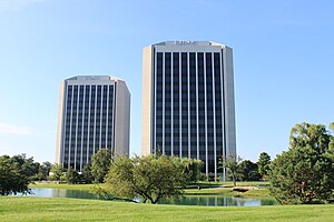
Parklane Towers
Distance: Approx. 2060 meters
Latitude and longitude: 42.32422,-83.20948
The Parklane Towers complex is a pair of twin office buildings in Dearborn, Michigan, United States, known locally as the "salt and pepper shakers" or "washer and dryer" Parklane Towers East is located at 1 Parklane Boulevard in Dearborn, Michigan. It was constructed in 1971 and stands at 15 stories. The older of the twin buildings is used for offices, retail, and other commercial space.
Edward Hotel & Convention Center
Hotel in Michigan, United States
Distance: Approx. 2183 meters
Latitude and longitude: 42.31211111,-83.21780556
The Edward Hotel & Convention Center was a 14-story, 773-room former conference center hotel located in the Metro Detroit suburb of Dearborn, Michigan at 600 Town Center Drive, near the intersection of M-39 and U.S. Highway 12. It was the second largest hotel in Michigan, after the Marriott in Detroit's Renaissance Center.
Dearborn Ice Skating Center
Indoor Ice Arena
Distance: Approx. 2110 meters
Latitude and longitude: 42.3304,-83.1893
Dearborn Ice Skating Center (The DISC, formerly Mike Adray Arena) is a 1,700-seat indoor ice arena located in Dearborn, Michigan, United States, in Metro Detroit. It is used primarily for high school and youth hockey as well as for ice skating. There are 1,500 seats at the main arena and another 200 in the viewing area.

Henry Ford Centennial Library
Distance: Approx. 950 meters
Latitude and longitude: 42.31317,-83.20262
The Henry Ford Centennial Library is the main branch of the Dearborn Public Libraries in Dearborn, Michigan in Metro Detroit. It is located at 16301 Michigan Avenue.

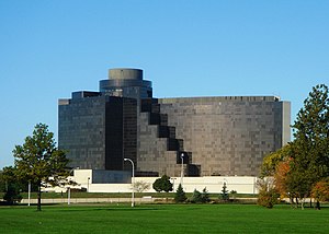
Ford World Headquarters
Administrative headquarters for Ford Motor Company
Distance: Approx. 1618 meters
Latitude and longitude: 42.31527778,-83.21027778
The Henry Ford II World Center, also commonly known as the Ford World Headquarters and popularly known as the Glass House, is the administrative headquarters for Ford Motor Company, a 12-story, glass-faced office building designed to accommodate a staff of approximately 3,000. The building is located at 1 American Road at Michigan Avenue in Dearborn, Michigan, near Ford's historic Rouge plant, Greenfield Village, the Henry Ford Museum, Dearborn's Henry Ford Centennial Library, and Fair Lane, Henry Ford's personal estate. In 2008, columnist George Will said the building opened at "the peak of American confidence" and described the headquarters as having a "sleek glass-and-steel minimalism that characterized up-to-date architecture in the 1950s, when America was at the wheel of the world and even buildings seemed streamlined for speed".
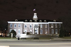
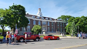
Dearborn City Hall Complex
United States historic place
Distance: Approx. 1632 meters
Latitude and longitude: 42.32138889,-83.17666667
The Dearborn City Hall Complex is a complex of three government buildings located at 13615 Michigan Avenue in Dearborn, Michigan. The complex includes the 1921 Dearborn City Hall (originally the Springwells Municipal Building), the 1929 Police and Municipal Courts Building, and an office/auditorium concourse addition constructed in 1981. The complex was listed on the National Register of Historic Places in 2014.
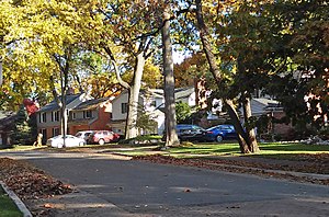
Springwells Park Historic District
Historic district in Michigan, United States
Distance: Approx. 439 meters
Latitude and longitude: 42.30805556,-83.19388889
The Springwells Park Historic District is a historic residential neighborhood located in Dearborn, Michigan and bounded by Rotunda Drive, the Michigan Central Railroad line, and Greenfield and Eastham Roads. The district was listed on the National Register of Historic Places in 2015.
Weather in this IP's area
broken clouds
16 Celsius
16 Celsius
13 Celsius
19 Celsius
1010 hPa
76 %
10000 meters
3.6 m/s
50 degree
75 %
22:00:00
10:00:00
The latest IP detection test
- 71.193.169.50
- 108.163.64.67
- 187.16.12.196
- 41.103.227.210
- 166.167.79.184
- 174.32.165.18
- 225.27.222.185
- 163.26.79.38
- 248.106.226.7
- 167.67.206.210