Country:
 Brazil
Region:
City:
Latitude and Longitude:
Time Zone:
Postal Code:
IP information under different IP Channel
ip-api
Country
Region
City
ASN
Time Zone
ISP
Blacklist
Proxy
Latitude
Longitude
Postal
Route
IPinfo
Country
Region
City
ASN
Time Zone
ISP
Blacklist
Proxy
Latitude
Longitude
Postal
Route
MaxMind
Country
Region
City
ASN
Time Zone
ISP
Blacklist
Proxy
Latitude
Longitude
Postal
Route
Luminati
Country
BRRegion
sp
City
embudasartes
ASN
Time Zone
America/Sao_Paulo
ISP
Keraxweb Servicos de Int. e Internet Ltda
Latitude
Longitude
Postal
db-ip
Country
Region
City
ASN
Time Zone
ISP
Blacklist
Proxy
Latitude
Longitude
Postal
Route
ipdata
Country
Region
City
ASN
Time Zone
ISP
Blacklist
Proxy
Latitude
Longitude
Postal
Route
Popular places and events near this IP address

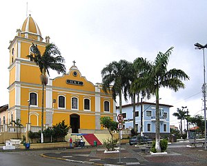
Embu das Artes
Municipality in the Brazilian state of São Paulo
Distance: Approx. 698 meters
Latitude and longitude: -23.64888889,-46.85194444
Embu das Artes, previously and commonly known simply as Embu, is a Brazilian municipality in the State of São Paulo. It is part of the Metropolitan Region of São Paulo. The population is 276,535 (2020 est.) in an area of 70.40 km2.
Itapecerica da Serra
Municipality in Southeast Brazil, Brazil
Distance: Approx. 7383 meters
Latitude and longitude: -23.71722222,-46.84944444
Itapecerica da Serra (Portuguese pronunciation: [itapeˈsɛɾikɐ dɐ ˈsɛʁɐ]) is a municipality in the Brazilian state of São Paulo. It is part of the Metropolitan Region of São Paulo. The population is 177,662 (2020 est.) in an area of 150.74 km2 (58.20 sq mi).
M'Boi Mirim
Distance: Approx. 8583 meters
Latitude and longitude: -23.68611112,-46.77055557
M'Boi Mirim (Portuguese pronunciation: [mˈbojmiˈɾĩ]) is a road in the city of São Paulo, Brazil. Its name comes from the Tupi language and means "little snake". It comprises two districts: Jardim Ângela and Campo Limpo.

Roman Catholic Diocese of Campo Limpo
Catholic ecclesiastical territory
Distance: Approx. 7536 meters
Latitude and longitude: -23.631,-46.7749
The Roman Catholic Diocese of Campo Limpo (Latin: Dioecesis Campi Limpidi) is a diocese located in the city of Campo Limpo Paulista in the ecclesiastical province of São Paulo in Brazil.

Granja Viana
District in Cotia, São Paulo, Brazil
Distance: Approx. 5913 meters
Latitude and longitude: -23.59833333,-46.85305556
Granja Viana (commonly known as Granja, sometimes spelled as Granja Vianna) is an upscale district in the city of Cotia, São Paulo, Brazil. Officially, the district is located in the east side of the city, but some portions of southern Carapicuíba, northern Embu das Artes and eastern Jandira are often referred to as Granja Viana as well. It can be accessed via the Raposo Tavares Highway.
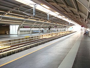
Capão Redondo (São Paulo Metro)
Metro station in São Paulo, Brazil
Distance: Approx. 7938 meters
Latitude and longitude: -23.6592509,-46.7681766
Capão Redondo is a metro station on Line 5 (Lilac) of the São Paulo Metro in the Capão Redondo district of São Paulo, Brazil and is the western terminus.

Subprefecture of Campo Limpo
Subprefecture in Southeast, Brazil
Distance: Approx. 8276 meters
Latitude and longitude: -23.63333333,-46.76666667
The Subprefecture of Campo Limpo is one of 32 subprefectures of the city of São Paulo, Brazil. It comprises three districts: Campo Limpo, Capão Redondo, and Vila Andrade. The slum of Paraisópolis, the second largest of the city and surrounded by middle-to-upper class apartment buildings, is located here.

Subprefecture of M'Boi Mirim
Subprefecture in Southeast, Brazil
Distance: Approx. 8583 meters
Latitude and longitude: -23.68611111,-46.77055556
The Subprefecture of M'Boi Mirim is one of 32 subprefectures of the city of São Paulo, Brazil. It comprises two districts: Jardim Ângela and Jardim São Luís. The area is serviced by Line 5 of the São Paulo Metro.

Escola Japonesa de São Paulo
Japanese international school in Brazil
Distance: Approx. 8151 meters
Latitude and longitude: -23.645,-46.76583333
The Escola Japonesa de São Paulo (Portuguese: [isˈkɔlɐ ʒɐpoˈnezɐ dʒi sɐ̃w ˈpawlu], "São Paulo Japanese School"; Japanese: サンパウロ日本人学校, romanized: Sanpauro Nihonjin Gakkō) is a Japanese international day school in Vila Prel, Capão Redondo, Subprefecture of Campo Limpo, São Paulo, operated by the Sociedade Japonesa de Educação e Cultura. It serves students from 6 to 15 years of age in grades 1 through 9. Most of the students have Japanese company executives as parents.

Capão Redondo
District of São Paulo, Brazil
Distance: Approx. 7946 meters
Latitude and longitude: -23.6687,-46.77
Capão Redondo is one of 96 districts in the city of São Paulo, Brazil.

UNASP São Paulo Memory Center
First museological institution in Capão Redondo, São Paulo, Brazil.
Distance: Approx. 6938 meters
Latitude and longitude: -23.66675,-46.77966667
Created and maintained by the Adventist University Center of São Paulo (UNASP) São Paulo campus, the UNASP São Paulo Memory Center is the first museological institution in Capão Redondo. It aims to preserve and disseminate the memory of UNASP, as well as of the early days of the Capão Redondo neighborhood, located in the southern part of the city of São Paulo. The museum produces research, exhibitions, events and books relating the history of the neighborhood and the memory of its sustaining institution, as well as of the Seventh-day Adventist Church and the Adventist Education Network.

Adventist University Center of São Paulo
Education institute in Brazil
Distance: Approx. 6591 meters
Latitude and longitude: -23.66642274,-46.78308747
The Adventist University Center of São Paulo (Portuguese: Centro Universitário Adventista de São Paulo), also known as UNASP, is a basic and higher education institution that integrates the Seventh-day Adventist education system. It has 3 campuses in the state of São Paulo: São Paulo (headquarters), Engenheiro Coelho, and Hortolândia. It also runs an application center in Artur Nogueira and offers distance education.
Weather in this IP's area
clear sky
20 Celsius
20 Celsius
19 Celsius
21 Celsius
1015 hPa
74 %
1015 hPa
926 hPa
10000 meters
2.57 m/s
40 degree
05:47:13
18:06:25