Country:
Region:
City:
Latitude and Longitude:
Time Zone:
Postal Code:
IP information under different IP Channel
ip-api
Country
Region
City
ASN
Time Zone
ISP
Blacklist
Proxy
Latitude
Longitude
Postal
Route
Luminati
Country
Region
cal
City
riosucio
ASN
Time Zone
America/Bogota
ISP
CENTRAL DE SERVICIOS DIGITALES S.A.S.
Latitude
Longitude
Postal
IPinfo
Country
Region
City
ASN
Time Zone
ISP
Blacklist
Proxy
Latitude
Longitude
Postal
Route
db-ip
Country
Region
City
ASN
Time Zone
ISP
Blacklist
Proxy
Latitude
Longitude
Postal
Route
ipdata
Country
Region
City
ASN
Time Zone
ISP
Blacklist
Proxy
Latitude
Longitude
Postal
Route
Popular places and events near this IP address

Colombian coffee growing axis
Region of Colombia known for growing coffee
Distance: Approx. 6572 meters
Latitude and longitude: 5.47166667,-75.68166667
The Colombian coffee region (Spanish: Eje Cafetero), also known as the Coffee Triangle (Spanish: Triángulo del Café) is a part of the Paisa region in the rural area of Colombia. It is famous for growing and producing the majority of Colombian coffee. There are four departments in the area: Caldas, Quindío, Risaralda and Tolima.

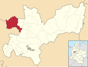
Riosucio, Caldas
Municipality and town in Caldas Department, Colombia
Distance: Approx. 819 meters
Latitude and longitude: 5.42083333,-75.7025
Riosucio is a town and municipality in the department of Caldas in Colombia. It is best known for its biennial carnival, officially called the Carnival of Riosucio but commonly known by its former name of the "Carnival of the Devil", and is one of the biggest and most popular carnivals in Colombia. Located along the Colombian coffee growing axis, the municipality was made part of the "Coffee Cultural Landscape" UNESCO World Heritage Site in 2011.

Supía, Caldas
Municipality and town in Caldas Department, Colombia
Distance: Approx. 8441 meters
Latitude and longitude: 5.46666667,-75.65
Supía is a town and municipality in the Colombian Department of Caldas. Located along the Colombian coffee growing axis, it was part of the "Coffee Cultural Landscape" UNESCO World Heritage Site in 2011.

Quinchía
Town and Municipality in Risaralda, Colombia
Distance: Approx. 9373 meters
Latitude and longitude: 5.33785,-75.72964722
Quinchía, also known as Villa de los Cerros (Village of the Hills), is a town and municipality in the Department of Risaralda, Colombia. About 110 km away from the capital Pereira. In 2023 the town had an estimated population of 27,890.

Coffee production in Colombia
UNESCO World Heritage Site in Colombia
Distance: Approx. 6572 meters
Latitude and longitude: 5.47166667,-75.68166667
Coffee production in Colombia has a reputation for producing mild, well-balanced coffee beans. Colombia's average annual coffee production of 11.5 million bags is the third total highest in the world, after Brazil and Vietnam, though highest in terms of the arabica bean. The beans are exported to United States, Germany, France, Japan, and Italy.
Quinchía mine
Mine in Quinchía, Risaralda, Colombia
Distance: Approx. 9819 meters
Latitude and longitude: 5.33447222,-75.73261111
The Quinchía mine is a gold mine in Colombia. The mine is located in Quinchía, Risaralda. The mine has estimated reserves of 390,000 ounces (11 t) of gold and 817,000 ounces (23.2 t) of silver.
Weather in this IP's area
overcast clouds
18 Celsius
18 Celsius
16 Celsius
19 Celsius
1016 hPa
86 %
1016 hPa
828 hPa
10000 meters
0.36 m/s
0.53 m/s
122 degree
99 %
05:52:23
17:44:10