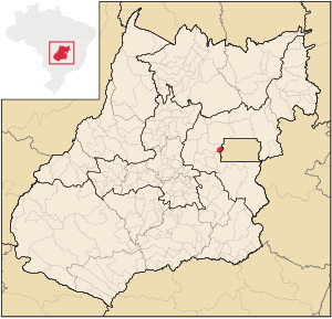
Country:
Region:
City:
Latitude and Longitude:
Time Zone:
Postal Code:
IP information under different IP Channel
ip-api
Country
Region
City
ASN
Time Zone
ISP
Blacklist
Proxy
Latitude
Longitude
Postal
Route
Luminati
Country
Region
go
City
aguaslindasdegoias
ASN
Time Zone
America/Sao_Paulo
ISP
ALLREDE TELECOM LTDA
Latitude
Longitude
Postal
IPinfo
Country
Region
City
ASN
Time Zone
ISP
Blacklist
Proxy
Latitude
Longitude
Postal
Route
db-ip
Country
Region
City
ASN
Time Zone
ISP
Blacklist
Proxy
Latitude
Longitude
Postal
Route
ipdata
Country
Region
City
ASN
Time Zone
ISP
Blacklist
Proxy
Latitude
Longitude
Postal
Route
Popular places and events near this IP address

Águas Lindas de Goiás
Municipality in Central-West, Brazil
Distance: Approx. 1046 meters
Latitude and longitude: -15.75444444,-48.28194444
Águas Lindas de Goiás is a municipality located in central Goiás, Brazil. It is the fifth largest city in the state and one of the fastest-growing cities in Brazil.

Microregion of Entorno do Distrito Federal
Microregion in Goiás, Brazil
Distance: Approx. 575 meters
Latitude and longitude: -15.76194444,-48.28194444
Entorno do Distrito Federal Microregion (also: Entorno de Brasília) is a statistical microregion in Goiás state, Brazil, consisting of municipalities located in the vicinity of the Federal District of Brazil.
Weather in this IP's area
scattered clouds
27 Celsius
29 Celsius
24 Celsius
27 Celsius
1013 hPa
65 %
1013 hPa
898 hPa
10000 meters
1.79 m/s
2.24 m/s
43 %
05:32:04
18:25:33