Country:
 Mexico
Region:
City:
Latitude and Longitude:
Time Zone:
Postal Code:
IP information under different IP Channel
ip-api
Country
Region
City
ASN
Time Zone
ISP
Blacklist
Proxy
Latitude
Longitude
Postal
Route
IPinfo
Country
Region
City
ASN
Time Zone
ISP
Blacklist
Proxy
Latitude
Longitude
Postal
Route
MaxMind
Country
Region
City
ASN
Time Zone
ISP
Blacklist
Proxy
Latitude
Longitude
Postal
Route
Luminati
Country
MXRegion
roo
City
playadelcarmen
ASN
Time Zone
America/Cancun
ISP
Operbes, S.A. de C.V.
Latitude
Longitude
Postal
db-ip
Country
Region
City
ASN
Time Zone
ISP
Blacklist
Proxy
Latitude
Longitude
Postal
Route
ipdata
Country
Region
City
ASN
Time Zone
ISP
Blacklist
Proxy
Latitude
Longitude
Postal
Route
Popular places and events near this IP address

Playa del Carmen
City in Quintana Roo, Mexico
Distance: Approx. 455 meters
Latitude and longitude: 20.6281425,-87.0755
Playa del Carmen, known colloquially as 'Playa', is a resort city located along the Caribbean Sea in the state of Quintana Roo, Mexico. It is part of the municipality of Solidaridad. As of 2020, the city's population was just over 300,000 people during 2020, a small yet thriving portion of which are foreign immigrants.
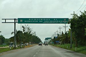
Solidaridad Municipality
Municipality in Quintana Roo, Mexico
Distance: Approx. 1076 meters
Latitude and longitude: 20.61666667,-87.08333333
Solidaridad is one of the eleven municipalities that make up the Mexican state of Quintana Roo. Its municipal seat is the town of Playa del Carmen. Solidaridad is home to the Maya archaeological site of Xcaret.
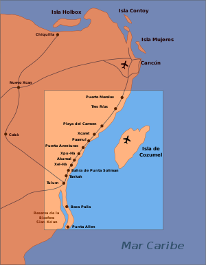
Riviera Maya
Tourist resort district near Cancún, Mexico
Distance: Approx. 890 meters
Latitude and longitude: 20.63138889,-87.07305556
The Riviera Maya (Spanish pronunciation: [ri'βjeɾa 'maʝa]) is a tourism and resort district south of Cancun, Mexico. It straddles the coastal Federal Highway 307, along the Caribbean coastline of the state of Quintana Roo, located in the eastern portion of the Yucatán Peninsula. Originally the name applied narrowly, focusing on the area of coastline between the city of Playa del Carmen and Tulum.
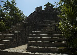
Xcaret
Maya civilization archaeological site
Distance: Approx. 6768 meters
Latitude and longitude: 20.57805556,-87.11916667
Xcaret (Mayan pronunciation: [ʃkaˈɾet]) is a Maya civilization archaeological site located on the Caribbean coastline of the Yucatán Peninsula, in the state of Quintana Roo in Mexico. The site was occupied by the pre-Columbian Maya and functioned as a port for navigation and an important Maya trading center. Some of the site's original structures are contained within a modern-day tourism development, the privately-owned Xcaret Park.
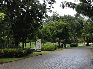
Playacar
Distance: Approx. 1076 meters
Latitude and longitude: 20.61666667,-87.08333333
Playacar is an upscale resort area of Playa del Carmen. Located in Playa del Carmen in the state of Quintana Roo, Mexico in the municipality of Solidaridad, it is a gated community that has grown with Playa del Carmen, just south of its main urban area. Playacar is approximately a 40 minute drive from Cancun.
Instituto Via Delphi
Mexican non-profit organization
Distance: Approx. 6402 meters
Latitude and longitude: 20.58040278,-87.11668889
The Via Delphi Institute for Research on Marine Mammals is a Mexican non-profit organization endorsed to generate scientific knowledge about marine mammals, mostly of the Tursiops truncatus species. The research center is located in the state of Quintana Roo, near Cancún, where the scientific members make indoor studies; by the other side, The Via Delphi Institute conducts research programs with wild dolphin populations from the Campeche and Tabasco costs, in the Gulf of Mexico, and in Holbox Island, located in the Mexican Caribbean Sea. The institute is divided in two working groups, one composed of biologists and the other of veterinarians, both supported by thesis students and volunteers.

First federal electoral district of Quintana Roo
Federal electoral district of Mexico
Distance: Approx. 1473 meters
Latitude and longitude: 20.63333333,-87.06666667
The first federal electoral district of Quintana Roo (Distrito electoral federal 01 de Quintana Roo) is one of the 300 electoral districts into which Mexico is divided for elections to the federal Chamber of Deputies and one of four such districts in the state of Quintana Roo. It elects one deputy to the lower house of Congress for each three-year legislative session by means of the first-past-the-post system. Votes cast in the district also count towards the calculation of proportional representation ("plurinominal") deputies elected from the third region.

Xcaret Park
Theme park in Mexico
Distance: Approx. 6768 meters
Latitude and longitude: 20.57805556,-87.11916667
Xcaret Park (Spanish: Parque Xcaret; Spanish pronunciation: [ˈpaɾke ʃkaˈɾet]) is a privately owned and operated theme park, resort and self-described ecotourism development located in the Riviera Maya, a portion of the Caribbean coastline of Mexico's state of Quintana Roo. It is part of Xcaret Experiencias Group which also owns the Xplor Park, Xel-Ha Park, and Xenses Park; as well as the Xichen, Xenotes, Xavage and Xoximilco tours and activities. It is situated approximately 75 kilometres (47 mi) south of Cancún, and 6.5 kilometres (4 mi) south of the nearest large settlement Playa del Carmen along Highway 307.
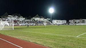
Estadio Unidad Deportiva
Stadium in Carmen, Mexico
Distance: Approx. 1352 meters
Latitude and longitude: 20.63480778,-87.07048278
Estadio de la Unidad Deportiva Mario Villanueva Madrid is a stadium in Playa del Carmen, Mexico. It is primarily used for soccer, and is the home field of the Inter Playa del Carmen soccer team in Mexico's third division. It holds 7,500 people and features a natural grass surface.
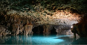
Río Secreto
Semi-flooded cave system in the Yucatan Peninsula, Mexico
Distance: Approx. 7230 meters
Latitude and longitude: 20.588941,-87.135198
Río Secreto (English translation: Secret River) is a semi-flooded limestone cave system near Playa del Carmen, Quintana Roo, Mexico. There are 38 kilometers of caves in the system, of which approximately 10% are used for ecotourism. Currently, Río Secreto is protected as a nature reserve.

Xplor Park
Theme park in Mexico
Distance: Approx. 6768 meters
Latitude and longitude: 20.57805556,-87.11916667
Xplor Park (Spanish: el parque Xplor) is a privately owned and operated theme park located in the Riviera Maya in Quintana Roo, Mexico. The park's signature offering is its ziplines, and it is the most-visited zipline attraction in the world. The park's attractions are built into the landscape of the Yucatán Peninsula and bring visitors into natural caves, rivers and cenotes.

Ha' (restaurant)
Mexican restaurant in Playa del Carmen, Mexico
Distance: Approx. 5572 meters
Latitude and longitude: 20.58652778,-87.11208333
Ha' is a Mexican restaurant at Playa del Carmen's Hotel Xcaret, in Quintana Roo, Mexico. Carlos Gaytán is the chef. The restaurant has received a Michelin star.
Weather in this IP's area
broken clouds
31 Celsius
38 Celsius
30 Celsius
31 Celsius
1008 hPa
74 %
1008 hPa
1008 hPa
10000 meters
3.09 m/s
10 degree
75 %
06:36:35
18:47:21