Country:
 Mexico
Region:
City:
Latitude and Longitude:
Time Zone:
Postal Code:
IP information under different IP Channel
ip-api
Country
Region
City
ASN
Time Zone
ISP
Blacklist
Proxy
Latitude
Longitude
Postal
Route
IPinfo
Country
Region
City
ASN
Time Zone
ISP
Blacklist
Proxy
Latitude
Longitude
Postal
Route
MaxMind
Country
Region
City
ASN
Time Zone
ISP
Blacklist
Proxy
Latitude
Longitude
Postal
Route
Luminati
Country
MXRegion
nle
City
monterrey
ASN
Time Zone
America/Monterrey
ISP
Operbes, S.A. de C.V.
Latitude
Longitude
Postal
db-ip
Country
Region
City
ASN
Time Zone
ISP
Blacklist
Proxy
Latitude
Longitude
Postal
Route
ipdata
Country
Region
City
ASN
Time Zone
ISP
Blacklist
Proxy
Latitude
Longitude
Postal
Route
Popular places and events near this IP address

Talleres metro station
Monterrey metro station
Distance: Approx. 3730 meters
Latitude and longitude: 25.75388889,-100.36527778
Talleres Station (Spanish: Terminal Talleres) is a terminal station on Line 1 of the Monterrey Metro. It is located on Ave. Solidaridad and Esquisto St.

Cerro del Topo Chico
Mountain in Nuevo León, Mexico
Distance: Approx. 6132 meters
Latitude and longitude: 25.77333333,-100.34972222
The Cerro del Topo Chico (Spanish, 'Small Mole Hill', from the Latin talpa 'mole') is a mountain and a protected area in the Escobedo, San Nicolás and Monterrey municipalities; state of Nuevo León, Mexico. The summit reaches 1,178 meters above sea level, and it has 618 meters of prominence (Parent: Cerro de las Mitras). The mountain is about 7.5 km long, is a symbol of Escobedo and San Nicolás, and is completely surrounded by Monterrey metropolitan area.
Instituto Regiomontano
Distance: Approx. 1984 meters
Latitude and longitude: 25.7255,-100.4073
Instituto Regiomontano is a private institution serving students from Pre-School through High School in Monterrey, Nuevo Leon. It is part of the Institute of the Brothers of the Christian Schools. It has two campuses: Chepe Vera and Cumbres.

San Bernabé metro station
Monterrey metro station
Distance: Approx. 3916 meters
Latitude and longitude: 25.74833333,-100.36166667
The San Bernabé Station (Spanish: Estación San Bernabé) is a station on Line 1 of the Monterrey Metro. It is located in the Solidaridad Avenue and Lic Julio Camelo intersection in Monterrey. This station is located in the Colon Avenue in the northeast side of the Monterrey Centre.

Penitenciaría metro station
Monterrey metro station
Distance: Approx. 6142 meters
Latitude and longitude: 25.72333333,-100.3425
Penitenciaría (Spanish: Estación de Penitenciaría) is a station on Line 1 of the Monterrey Metro. Its location is at Rodrigo Gómez Avenue in Monterrey, near the state criminal courthouses and Topo Chico prison. The station was opened on 25 April 1991 as part of the inaugural section of Line 1, going from San Bernabé to Exposición.

Unidad Modelo metro station
Monterrey metro station
Distance: Approx. 4522 meters
Latitude and longitude: 25.74194444,-100.355
The Unidad Modelo Station (Spanish: Estación Unidad Modelo) is a station on Line 1 of the Monterrey Metro. It is located on Aztlán Avenue in Monterrey in the heart of the heavy populated Unidad Modelo neighborhood. This station is located in the Colon Avenue in the northeast side of the Monterrey Centre.

Aztlán metro station
Monterrey metro station
Distance: Approx. 5388 meters
Latitude and longitude: 25.73222222,-100.3475
Aztlán Station (Spanish: Estación Aztlán) is a station on Line 1 of the Monterrey Metro. This station is located on Aztlán Avenue in Monterrey. This station is located in the Colon Avenue in the northeast side of the Monterrey Centre.

Alfonso Reyes metro station
Monterrey metro station
Distance: Approx. 6460 meters
Latitude and longitude: 25.71611111,-100.3425
Alfonso Reyes Station (Spanish: Estación Alfonso Reyes) is a station on Line 1 of the Monterrey Metro. It is located in the intersection of Rodrigo Gomez and Alfonso Reyes Avenues in Monterrey, México. This station is located in the Colon Avenue in the northeast side of the Monterrey Centre.

Mitras metro station
Monterrey metro station
Distance: Approx. 7065 meters
Latitude and longitude: 25.70555556,-100.3425
Mitras Station (Spanish: Estación Mitras) is a station on Line 1 of the Monterrey Metro. It is located in the intersection of Simón Bolívar and Ruiz Cortinez Avenues in Monterrey, México. This station is located in the Colon Avenue in the northeast side of the Monterrey Centre.
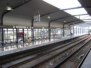
Simón Bolívar metro station (Monterrey)
Monterrey metro station
Distance: Approx. 7450 meters
Latitude and longitude: 25.69904,-100.34324
The Simón Bolívar Station (Spanish: Estación Simón Bolívar) is a station on Line 1 of the Monterrey Metro. It is located on Simón Bolivar Avenue. This station is located in the Colon Avenue in the northeast side of the Monterrey Centre.

Topo Chico (prison)
Prison located in Monterrey, northern Mexico
Distance: Approx. 5791 meters
Latitude and longitude: 25.725,-100.34555556
Topo Chico was a prison located in Monterrey, northern Mexico, close to Penitenciaría (Spanish for 'penitentiary') metro station. The prison is an establishment of the Federal Government of Mexico and is administered by the Secretariat of Public Security (Spanish: Secretaría de Seguridad Pública, SSP). The director of the prison is Gregoria Salazar Robles, appointed 12 March 2012.
San Pedro Garza García stage collapse
Fatal accident during a political rally in Mexico
Distance: Approx. 7285 meters
Latitude and longitude: 25.67666667,-100.40138889
On 22 May 2024, at 20:08 CST (UTC−6), a stage collapsed during a campaign rally for mayoral candidate Lorenia Canavati of the Citizens' Movement in San Pedro Garza García in the northeastern Mexican state of Nuevo León, killing ten people and injuring 213 others.
Weather in this IP's area
scattered clouds
27 Celsius
27 Celsius
25 Celsius
27 Celsius
1012 hPa
82 %
1012 hPa
941 hPa
10000 meters
0.89 m/s
2.24 m/s
44 degree
41 %
06:29:14
18:41:16