Country:
 Mexico
Region:
City:
Latitude and Longitude:
Time Zone:
Postal Code:
IP information under different IP Channel
ip-api
Country
Region
City
ASN
Time Zone
ISP
Blacklist
Proxy
Latitude
Longitude
Postal
Route
IPinfo
Country
Region
City
ASN
Time Zone
ISP
Blacklist
Proxy
Latitude
Longitude
Postal
Route
MaxMind
Country
Region
City
ASN
Time Zone
ISP
Blacklist
Proxy
Latitude
Longitude
Postal
Route
Luminati
Country
MXRegion
cmx
City
mexicocity
ASN
Time Zone
America/Mexico_City
ISP
AT&T COMUNICACIONES DIGITALES S DE RL
Latitude
Longitude
Postal
db-ip
Country
Region
City
ASN
Time Zone
ISP
Blacklist
Proxy
Latitude
Longitude
Postal
Route
ipdata
Country
Region
City
ASN
Time Zone
ISP
Blacklist
Proxy
Latitude
Longitude
Postal
Route
Popular places and events near this IP address

Zaragoza metro station (Mexico City)
Mexico City Metro station
Distance: Approx. 1189 meters
Latitude and longitude: 19.412344,-99.08241
Zaragoza metro station is a station of the Mexico City Metro in Venustiano Carranza, Mexico City. It is an underground station with two side platforms serving Line 1 (the Pink Line) between Gómez Farías and Pantitlán metro stations. The station opened on 4 September 1969, and opened the following day, as the first terminal of the line, with westward service toward Chapultepec station.

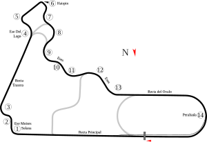
Autódromo Hermanos Rodríguez
Auto race track in Mexico City, Mexico
Distance: Approx. 432 meters
Latitude and longitude: 19.40611111,-99.0925
The Autódromo Hermanos Rodríguez is a 4.304 km (2.674 mi) motorsport race track in Mexico City, Mexico, named after the racing drivers Ricardo Rodríguez (1942–1962) and Pedro Rodríguez (1940–1971). The circuit got its name shortly after it opened when Ricardo Rodríguez died in practice for the non-Championship 1962 Mexican Grand Prix. Ricardo's brother Pedro was also killed behind the wheel nine years later.
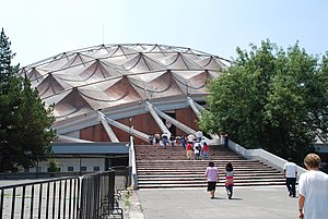
Palacio de los Deportes
Arena in Mexico City, Mexico
Distance: Approx. 1117 meters
Latitude and longitude: 19.40527778,-99.09972222
Palacio de los Deportes (English: Sports Palace) is an indoor arena located in Mexico City, Mexico. It is within the Magdalena Mixhuca Sports City complex, near the Mexico City International Airport and in front of the Foro Sol, in which sports and artistic events are also celebrated. It is operated by Grupo CIE. The palace is named after Mexican military official Juan Escutia, although it is rarely referred to in its full name.

Estadio GNP Seguros
Mexico City multipurpose venue
Distance: Approx. 718 meters
Latitude and longitude: 19.40488889,-99.09594444
Estadio GNP Seguros, formerly known as Foro Sol, is a multipurpose stadium built in 1993 inside the Autódromo Hermanos Rodríguez in eastern Mexico City. It is located near the Mexico City International Airport and is operated by Grupo CIE. The venue was originally built for staging large music concerts. Initially called the Autódromo, it could accommodate up to 50,000 people.

Ciudad Deportiva metro station
Mexico City metro station
Distance: Approx. 550 meters
Latitude and longitude: 19.408357,-99.091229
Ciudad Deportiva (Spanish: Estación Ciudad Deportiva) is a metro station along Line 9 of the Mexico City Metro. It is named for the nearby the Magdalena Mixhuca Sports City. Magdalena Mixuhca Sports City was enlarged in 1967 as part of the project to create the venues needed for the 1968 Summer Olympics.

Puebla metro station
Mexico City metro station
Distance: Approx. 802 meters
Latitude and longitude: 19.407142,-99.082432
Puebla is a station on the Mexico City Metro. It is located in the Puebla district of the Iztacalco delegation of Mexico City; both the area it is located in and the station are named for the nearby city of Puebla. The station logo represents some angels, as the city is commonly called The City of Angels.
Gran Premio Tecate
Motor race
Distance: Approx. 432 meters
Latitude and longitude: 19.40611111,-99.0925
The Gran Premio Tecate was a round of the Champ Car World Series held on the Autodromo Hermanos Rodriguez circuit in Mexico City, Mexico. It was first held in 1980, and in its first two years of competition was the penultimate round of the championship. After its re-inception in 2002, it was the season-ending round.
2004 Gran Premio Telmex/Tecate
Motor car race
Distance: Approx. 432 meters
Latitude and longitude: 19.40611111,-99.0925
The 2004 Gran Premio Telmex/Tecate was the fourteenth and final round of the 2004 Bridgestone Presents the Champ Car World Series Powered by Ford season, held on November 7, 2004, at the Autódromo Hermanos Rodríguez in Mexico City, Mexico. Sébastien Bourdais won the pole and the race and in doing so also secured his first of four Champ Car titles.
Magdalena Mixhuca Sports City
Mexico City sports venue
Distance: Approx. 744 meters
Latitude and longitude: 19.40527778,-99.09611111
The Magdalena Mixhuca Sports City is an Olympic Park which was used during the 1968 Summer Olympics. Found in the area of Mexico City known as the Magdalena Mixhuca, the park continues to serve as a venue for cultural, social, worship and sport events. The Park is administered by the government of Mexico City.
Fernando Montes de Oca Fencing Hall
Distance: Approx. 487 meters
Latitude and longitude: 19.4075,-99.09166667
The Fernando Montes de Oca Fencing Hall is an indoor sports venue located in the Magdalena Mixhuca Sports City area of Mexico City. It hosted the fencing competitions and the fencing part of the modern pentathlon competition of the 1968 Summer Olympics. The Olympic Fencing Hall was built between November 13, 1967, and September, 1968, in the Magdalena Mixhuca Sports City.

Estadio Jesús Martínez "Palillo"
Multi-use stadium in the Magdalena Mixhuca Sports City in Mexico City
Distance: Approx. 753 meters
Latitude and longitude: 19.40777778,-99.095
The Estadio Jesús Martínez "Palillo" is a multi-use stadium located in the Magdalena Mixhuca Sports City in Mexico City. It is currently the home of the Mexicas of the Liga de Fútbol Americano Profesional (LFA), Chilangos F.C. of the Serie B de México, Neza and Proyecto RED of the Liga de Balompié Mexicano. The stadium has a capacity of 6,000 seated spectators.

Estadio Alfredo Harp Helú
Baseball stadium in Mexico City
Distance: Approx. 389 meters
Latitude and longitude: 19.404,-99.0855
Estadio Alfredo Harp Helú (English: Alfredo Harp Helú Stadium) is a baseball stadium in Mexico City, located within the Magdalena Mixhuca Sports City in the Iztacalco borough. It is the ballpark of Mexican League's Diablos Rojos del México. Inaugurated on 23 March 2019, the stadium has a capacity of 20,062 seats.
Weather in this IP's area
broken clouds
21 Celsius
20 Celsius
21 Celsius
22 Celsius
1014 hPa
60 %
1014 hPa
789 hPa
9656 meters
2.06 m/s
10 degree
75 %
06:24:47
18:35:14