Country:
Region:
City:
Latitude and Longitude:
Time Zone:
Postal Code:
IP information under different IP Channel
ip-api
Country
Region
City
ASN
Time Zone
ISP
Blacklist
Proxy
Latitude
Longitude
Postal
Route
Luminati
Country
Region
cmx
City
benitojuarez
ASN
Time Zone
America/Mexico_City
ISP
AT&T COMUNICACIONES DIGITALES S DE RL
Latitude
Longitude
Postal
IPinfo
Country
Region
City
ASN
Time Zone
ISP
Blacklist
Proxy
Latitude
Longitude
Postal
Route
db-ip
Country
Region
City
ASN
Time Zone
ISP
Blacklist
Proxy
Latitude
Longitude
Postal
Route
ipdata
Country
Region
City
ASN
Time Zone
ISP
Blacklist
Proxy
Latitude
Longitude
Postal
Route
Popular places and events near this IP address

Chapultepec
Urban park in Mexico City
Distance: Approx. 949 meters
Latitude and longitude: 19.41305556,-99.19777778
Chapultepec, more commonly called the "Bosque de Chapultepec" (Chapultepec Forest) in Mexico City, is one of the largest city parks in Mexico, measuring in total just over 686 hectares (1,700 acres). Centered on a rock formation called Chapultepec Hill, one of the park's main functions is as an ecological space in Greater Mexico City. It is considered the first and most important of Mexico City's "lungs".

Auditorio Nacional (Mexico)
Entertainment center in Mexico City
Distance: Approx. 1090 meters
Latitude and longitude: 19.42472222,-99.19491667
National Auditorium (Spanish: Auditorio Nacional) is an entertainment center at Paseo de la Reforma #50, Chapultepec in Mexico City. The National Auditorium is considered among the world's best venues by specialized media. It was designed by Mexican architects Pedro Ramírez Vázquez and Gonzalo Ramírez del Sordo, and remodeled by Abraham Zabludovsky and Teodoro González de León.

Montaña Rusa (La Feria Chapultepec Mágico)
Roller coaster
Distance: Approx. 923 meters
Latitude and longitude: 19.41638889,-99.19555556
Montaña Rusa was a wooden roller coaster at La Feria Chapultepec Mágico in Mexico City, Mexico. In 1993, it was renamed Serpiente de Fuego (Serpent of Fire) but later it was changed back to Montaña Rusa. For several years, Montaña Rusa held the record of world's tallest roller coaster.
La Feria de Chapultepec
Former amusement park in Mexico City, Mexico
Distance: Approx. 923 meters
Latitude and longitude: 19.41638889,-99.19555556
La Feria de Chapultepec (transl. Chapultepec Fair), simply branded as La Feria, was an amusement park in Mexico City, Mexico. Located in the middle of Chapultepec Park near the Constituyentes Metro station, it opened in 1964 as Juegos Mecánicos de Chapultepec (transl. Chapultepec Mechanical Games) and was originally operated by the Mexican government. In 1992 Grupo CIE bought it and changed the name to La Feria Chapultepec Mágico (transl. Magic Chapultepec Fair).

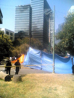
2008 Mexico City Learjet crash
2008 aviation accident in Mexico
Distance: Approx. 767 meters
Latitude and longitude: 19.42638889,-99.20361111
On 4 November 2008 an official Mexican Secretariat of the Interior aircraft crashed in central Mexico City at around 18:45 local time. There were sixteen fatalities—all nine people on board and seven people on the ground. The plane, a Learjet 45, was carrying Mexican Secretary of the Interior Juan Camilo Mouriño.

Papalote Museo del Niño
Distance: Approx. 1307 meters
Latitude and longitude: 19.4117,-99.1944
The museum Papalote Museo del Niño is located in Mexico City Bosques de Chapultepec. The museum is focused in learning, communication and working together through interactive expositions of science, technology and art for children.

Campo Marte
Distance: Approx. 895 meters
Latitude and longitude: 19.42472222,-99.19722222
Campo Marte is a venue under the administration of the Secretariat of National Defense (SEDENA). Named after the Campus Martius (Field of Mars), it is used for military and government events, as well as equestrian events. Campo Marte is located next to the National Auditorium in Chapultepec Park, Mexico City.
Parque Lincoln
Park in Mexico City
Distance: Approx. 1270 meters
Latitude and longitude: 19.42972222,-99.19833333
Parque Lincoln is a city park in Mexico City, Mexico in the Polanco neighborhood. The park memorializes US President Abraham Lincoln and has a copy of Abraham Lincoln: The Man, also known as Standing Lincoln. The park also has a statue of Martin Luther King Jr.
Cárcamo de Dolores
Hydraulic structure in Chapultepec Park, Mexico City
Distance: Approx. 943 meters
Latitude and longitude: 19.412738,-99.198292
The Cárcamo de Dolores (Sump of Dolores) is a hydraulic structure located on the Second Section of Chapultepec Park, in Mexico City, comprising the building designed by architect Ricardo Rivas, inside the originally underwater mural Agua, el origen de la vida ("Water, source of life") of Mexican muralist Diego Rivera, the art installation Cámara Lambdoma by Ariel Guzik, and in outside, the Tlaloc Fountain, also of Rivera. The building was constructed in 1951 to commemorate the end of the works in 1943 of the Lerma System, which still supply water to Mexico City and still flows in the place, but diverted from own building. It is part of the Museo de Historia Natural y Cultura Ambiental (Museum of Natural History and Environmental Culture).
Statue of George Washington, Mexico City (1916)
Statue in Mexico City, erected 1916
Distance: Approx. 244 meters
Latitude and longitude: 19.4198,-99.2014
A statue of George Washington stands in Mexico City. It was presented as a gift to the city by the United States government in 1916. Since 1970, it has been located in the Parque Rosario Castellanos.

Memorial to Victims of Violence in Mexico
Monument in Mexico City
Distance: Approx. 775 meters
Latitude and longitude: 19.425,-99.19916667
The Memorial to Victims of Violence in Mexico (Spanish: Memorial a las víctimas de violencia en México), also referred to as the State Violence Victims Memorial (Spanish: Memorial de las víctimas de la violencia del Estado), is a memorial in Chapultepec, Mexico City. Its construction started in 2012 during the presidency of Felipe Calderón and it was opened on 5 April 2013, during Enrique Peña Nieto's administration. As its name suggests, it was created to pay tribute to those who had been victims of violence in the nation.

Aztlán Parque Urbano
An amusement park in Mexico City
Distance: Approx. 945 meters
Latitude and longitude: 19.416,-99.1955
Aztlán Parque Urbano is an amusement park in Chapultepec, Mexico City, Mexico. The park first opened on March 20, 2024, and replaced the amusement park La Feria de Chapultepec that closed in 2019.
Weather in this IP's area
broken clouds
21 Celsius
20 Celsius
20 Celsius
21 Celsius
1015 hPa
35 %
1015 hPa
784 hPa
10000 meters
4.12 m/s
360 degree
75 %
06:41:53
17:59:36


