Country:
Region:
City:
Latitude and Longitude:
Time Zone:
Postal Code:
IP information under different IP Channel
ip-api
Country
Region
City
ASN
Time Zone
ISP
Blacklist
Proxy
Latitude
Longitude
Postal
Route
Luminati
Country
Region
sp
City
campinas
ASN
Time Zone
America/Sao_Paulo
ISP
IP AMERICA TELECOM LTDA
Latitude
Longitude
Postal
IPinfo
Country
Region
City
ASN
Time Zone
ISP
Blacklist
Proxy
Latitude
Longitude
Postal
Route
db-ip
Country
Region
City
ASN
Time Zone
ISP
Blacklist
Proxy
Latitude
Longitude
Postal
Route
ipdata
Country
Region
City
ASN
Time Zone
ISP
Blacklist
Proxy
Latitude
Longitude
Postal
Route
Popular places and events near this IP address

Campinas
Municipality in Southeast, Brazil
Distance: Approx. 515 meters
Latitude and longitude: -22.90583333,-47.06083333
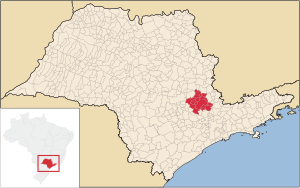
Campinas (Portuguese pronunciation: [kɐ̃ˈpinɐs], Plains or Meadows) is a Brazilian municipality in São Paulo State, part of the country's Southeast Region. According to the 2020 estimate, the city's population is 1,139,047, making it the fourteenth most populous Brazilian city and the third most populous municipality in São Paulo state, the fifth most populous municipality in Southeast Brazil, and the largest city in Brazil outside the metro region of a state capital. The city's metropolitan area, Metropolitan Region of Campinas, contains twenty municipalities with a total population of 3,656,363 people.

Colégio Culto à Ciência
Distance: Approx. 1291 meters
Latitude and longitude: -22.90065556,-47.06870833
The Colégio Culto à Ciência (Portuguese for "Cult to Science" High School), denominated E.E. Culto à Ciência), is a public secondary school located in the city of Campinas, state of São Paulo, Brazil. It was founded in 1874, as a boy's private school by Sociedade Culto à Ciência, which members were partly of the Mason's Commission of the Campinas' Justice Lodge "Independence". Composed by the city's farmers, merchants and intellectuals, among such were: Antônio Pompeu de Camargo; Francisco Glicério; Manoel Ferraz de Campos Salles, then the Secretary of the Campinas' Lodge (later, President of Brazil during 1898-1902); Jorge Krug; Joaquim Bonifácio do Amaral, the Viscount of Indaiatuba; Joaquim Egídio de Souza Aranha, the Marquis of Tres Rios; Cândido Ferreira; and, the Baron of Atibaia.
Correio Popular
Daily newspaper in Campinas, São Paulo, Brazil
Distance: Approx. 1310 meters
Latitude and longitude: -22.91473056,-47.06033056
Correio Popular is the largest daily newspaper in the city of Campinas, state of São Paulo, Brazil. It was founded on September 4, 1927, by Álvaro Ribeiro. The founder proposed a motto for the newspaper, which reads: "We will be diligent inspectors of public administration as well as obstinate caretakers of collective rights." Currently it has an audited circulation of 48,000 (66,000 on Sundays) and a market share of 76% of all newspaper readership in Campinas (which is the third city in the Brazilian ranking of absolute number of newspaper readers) [1].

Estádio Brinco de Ouro
Football stadium in Campinas, São Paulo state, Brazil
Distance: Approx. 1492 meters
Latitude and longitude: -22.90972222,-47.04361111
The Estádio Brinco de Ouro da Princesa Portuguese pronunciation: [isˈtadʒju ˈbɾĩku dʒi ˈowɾu] ("Princess' Golden Earring Stadium"), also known as Estádio Brinco de Ouro ("Golden Earring Stadium"), or just Brinco de Ouro ("Golden Earring"), is a football stadium inaugurated on May 31, 1953 in Campinas, São Paulo state, Brazil with a maximum capacity of 29,130 people. The stadium is owned by Guarani Futebol Clube and has a pitch size of 105,12m x 70,12m (today is 105m x 68m) Brinco de Ouro's architects were Ícaro de Castro Mello and Osvaldo Correio Gonçalves. The stadium's peculiar name comes from the presentation of the then-unnamed stadium's project to the newspaper Correio Popular with the title "Golden earring for the "princess", comparing the circular shape of the future stadium to an earring and making a pun with the nickname of the city of Campinas — Princesa D'Oeste (Princess of the West).
Estádio Moisés Lucarelli
Distance: Approx. 1242 meters
Latitude and longitude: -22.91361111,-47.05138889
Estádio Moisés Lucarelli Portuguese pronunciation: [isˈtadʒju mojˈzɛ(j)z lukaˈɾɛli], also known as Estádio Majestoso, or just Majestoso, is a football stadium inaugurated on September 12, 1948 in Campinas, São Paulo, with a maximum capacity of 19,728 spectators. The stadium is owned by Associação Atlética Ponte Preta. The stadium has a pitch size of 107m x 70m and its area stands at 36,000 m2.
Diário do Povo
Distance: Approx. 1310 meters
Latitude and longitude: -22.91473056,-47.06033056
Diário do Povo (Portuguese for People's Diary) is a newspaper published in the city of Campinas, state of São Paulo, Brazil. Correio Popular is owned and managed by a larger communications holding company, Rede Anhangüera de Comunicação, which operates a news agency (AAN), a printing facility (Grafcorp), a polls company (Datacorp) and owns also several other newspapers in Campinas, Piracicaba and Ribeirão Preto, such as Correio Popular (the largest newspaper in Campinas, with a 65% market share), Gazeta do Cambuí, Gazeta de Piracicaba, Gazeta de Ribeirão and the Metrópole magazine, which circulates on Sundays with Correio Popular. Diário do Povo, as the other RAC's newspapers are available on-line though a Web portal called Cosmo.

Instituto Agronômico de Campinas
Distance: Approx. 1517 meters
Latitude and longitude: -22.89199444,-47.06443333
The Instituto Agronômico de Campinas (Portuguese pronunciation: [ĩstʃiˈtutu aɡɾoˈnomiku dʒi kɐ̃ˈpinɐs]) (Agronomical Institute of Campinas—IAC) is a research and development institution affiliated to the Agência Paulista de Tecnologia dos Agronegócios (São Paulo Agency of Agrobusiness Technology), of the Secretary of Agriculture of the state of São Paulo, Brazil, with headquarters in the city of Campinas. It is the oldest institution of its kind in Latin America, having been founded by Emperor Dom Pedro II in 1887 as the Imperial Agronomical Station of Campinas. In 1892 it was transferred to the state government.

Parque Portugal
Distance: Approx. 3267 meters
Latitude and longitude: -22.87473889,-47.05013889
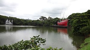
Parque Portugal, also known as Lagoa do Taquaral (Portuguese pronunciation: [laˈɡoɐ du taˈkwaɾaw]), is an urban public park in the city of Campinas, São Paulo, Brazil. It has been set around a beautiful lagoon and adjacent wooded park, and is a large municipal entertainment and sports park, with a planetarium, a science museum, an indoor sports stadium and swimming pool, kart racing and model airplane areas, an open concert auditorium, floating caravel replica, a working historical tramway, pedalos, facilities for several types of sports, including a long track for running, cycling and walking, restaurants, etc. Taquaral means "bamboo grove" in Portuguese, probably because the lagoon was originally rimmed with this kind of plant (it no longer is, instead eucalyptus trees have been planted around it).

Roman Catholic Archdiocese of Campinas
Catholic ecclesiastical territory
Distance: Approx. 487 meters
Latitude and longitude: -22.906,-47.0604
The Roman Catholic Archdiocese of Campinas (Latin: Archidioecesis Campinensis) is an archdiocese located in the city of Campinas in Brazil.

Campinas metropolitan area
Administrative division of São Paulo, Brazil
Distance: Approx. 510 meters
Latitude and longitude: -22.9058,-47.0608
The Metropolitan Region of Campinas (Portuguese: Região Metropolitana de Campinas) is an administrative division of the state of São Paulo in Brazil.

Basilica of Our Lady of Carmel, Campinas
Church in Campinas, Brazil
Distance: Approx. 438 meters
Latitude and longitude: -22.9017,-47.0603
The Basilica of Our Lady of Carmel (Portuguese: Basílica Nossa Senhora do Carmo) Also Basilica of Campinas Is a basilica located in the sector of Largo do Carmo, in the center of Campinas in the state of São Paulo in the south of Brazil. Originally it was the main church of the city and around which it developed Campinas. The original building began on July 14, 1774, with the first Mass, when the founding of the parish and the city of Campinas took place.

Campinas Cathedral shooting
2018 attack in Campinas, São Paulo, Brazil
Distance: Approx. 504 meters
Latitude and longitude: -22.906,-47.0606
On 11 December 2018, a gunman opened fire in the Metropolitan Cathedral in the Brazilian city of Campinas, São Paulo, killing five people and wounding four more. The event was reported by multiple news outlets.
Weather in this IP's area
clear sky
21 Celsius
21 Celsius
19 Celsius
21 Celsius
1011 hPa
60 %
1011 hPa
934 hPa
10000 meters
3.09 m/s
180 degree
05:15:25
18:32:20
