Country:
 Great Britain
Region:
City:
Latitude and Longitude:
Time Zone:
Postal Code:
IP information under different IP Channel
ip-api
Country
Region
City
ASN
Time Zone
ISP
Blacklist
Proxy
Latitude
Longitude
Postal
Route
IPinfo
Country
Region
City
ASN
Time Zone
ISP
Blacklist
Proxy
Latitude
Longitude
Postal
Route
MaxMind
Country
Region
City
ASN
Time Zone
ISP
Blacklist
Proxy
Latitude
Longitude
Postal
Route
Luminati
Country
GBRegion
eng
City
portsmouth
ASN
Time Zone
Europe/London
ISP
AllPoints Fibre Networks Limited
Latitude
Longitude
Postal
db-ip
Country
Region
City
ASN
Time Zone
ISP
Blacklist
Proxy
Latitude
Longitude
Postal
Route
ipdata
Country
Region
City
ASN
Time Zone
ISP
Blacklist
Proxy
Latitude
Longitude
Postal
Route
Popular places and events near this IP address

Fortifications of Portsmouth
Distance: Approx. 240 meters
Latitude and longitude: 50.799,-1.091
The fortifications of Portsmouth are extensive due to its strategic position on the English Channel and role as home to the Royal Navy. For this reason, Portsmouth was, by the 19th century, one of the most fortified cities in the world. The fortifications have evolved over the centuries in response to changes in tactics and technology and the area defended has increased.

University of Portsmouth
Public university in Portsmouth, England
Distance: Approx. 399 meters
Latitude and longitude: 50.79527778,-1.09333333
The University of Portsmouth (UoP) is a public university in Portsmouth, England. Comprising five faculties, the university offers a wide range of academic disciplines. With around 28,280 students enrolled in undergraduate and postgraduate programs, the university in 2022 was the 25th-largest higher education institution by student enrolments in the United Kingdom.

Portsmouth & Southsea railway station
Railway Station in Portsmouth, England
Distance: Approx. 285 meters
Latitude and longitude: 50.798448,-1.090393
Portsmouth & Southsea railway station is a Grade II listed building and the main railway station in the city of Portsmouth in Hampshire, England. It is in the Landport area close to the Commercial Road shopping area. British Transport Police maintain a presence at the station.
Roman Catholic Diocese of Portsmouth
Catholic diocese in England
Distance: Approx. 240 meters
Latitude and longitude: 50.799,-1.091
The Roman Catholic Diocese of Portsmouth (Latin: Dioecesis Portus Magni)is a Latin diocese of the Catholic Church that covers the Channel Islands as well as parts of England (Hampshire, the Isle of Wight and parts of Berkshire, Dorset and Oxfordshire). The episcopal see is St John's Cathedral in Portsmouth and is headed by the Bishop of Portsmouth. The diocese is part of the metropolitan Province of Southwark, which covers all of the far South of England as well as the Channel Islands.

Portsmouth Guildhall
Municipal building in Portsmouth, Hampshire, England
Distance: Approx. 151 meters
Latitude and longitude: 50.7979,-1.0928
Portsmouth Guildhall is a multi-use building in the centre of Portsmouth, Hampshire, England. It is located in a pedestrian square close to Portsmouth and Southsea railway station. Constructed in 1890, the building was known as Portsmouth Town Hall until 1926.

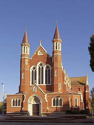
Cathedral of St John the Evangelist, Portsmouth
Church in Hampshire, England
Distance: Approx. 165 meters
Latitude and longitude: 50.80027778,-1.09416667
The Cathedral Church of St John the Evangelist (also known as St John's Cathedral) is a Roman Catholic cathedral in Portsmouth, England. It is the mother church of the Portsmouth diocese and seat of the Bishop of Portsmouth, currently the Right Reverend Philip Egan. It was dedicated on 10 August 1882.

United Services Recreation Ground
Distance: Approx. 382 meters
Latitude and longitude: 50.7959,-1.0973
The United Services Recreation Ground is a sports ground situated in Burnaby Road, Portsmouth, Hampshire, England. The ground is also bordered to the north by Park Road, along which the railway line to Portsmouth Harbour and Gunwharf Quays overlooks the ground, and to the east by Anglesea Road. The southern end of the ground is dominated by the Officer's Club building, which overlooks the ground.

New Theatre Royal
Theatre in Portsmouth, England
Distance: Approx. 270 meters
Latitude and longitude: 50.7965,-1.0932
The New Theatre Royal is a Victorian Grade II* listed theatre in the heart of Portsmouth, England, with a capacity of 648. The theatre building was constructed in 1854 as Landport Hall. It was converted to a theatre two years later.
Landport Drapery Bazaar
Former department store in Portsmouth
Distance: Approx. 339 meters
Latitude and longitude: 50.7999,-1.0899
Landport Drapery Bazaar was a department store located on Commercial Road, Portsmouth.

Stanhope Road drill hall, Portsmouth
Former English military installation
Distance: Approx. 186 meters
Latitude and longitude: 50.79945,-1.09196
The Stanhope Road drill hall, sometimes known as the Connaught Drill Hall, is a former military installation in Portsmouth, Hampshire. It is a Grade II listed building.

HMS Nelson (shore establishment)
Naval barracks for the Royal Navy
Distance: Approx. 157 meters
Latitude and longitude: 50.79944444,-1.09638889
HMS Nelson is a stone frigate (shore establishment) of the Royal Navy on Queen Street in Portsmouth, England. It provides the naval barracks to support HMNB Portsmouth and is also home to the Royal Marines School of Music.

Portsmouth Civic Offices
Municipal building in Portsmouth, Hampshire, England
Distance: Approx. 275 meters
Latitude and longitude: 50.7973,-1.0913
Portsmouth Civic Offices is a municipal building in Portsmouth, a city in Hampshire, in England. It is the administrative headquarters of Portsmouth City Council.
Weather in this IP's area
light rain
17 Celsius
17 Celsius
16 Celsius
18 Celsius
1004 hPa
77 %
1004 hPa
1003 hPa
10000 meters
3.58 m/s
7.15 m/s
202 degree
83 %
06:29:33
19:34:44