Country:
 Lithuania
Region:
City:
Latitude and Longitude:
Time Zone:
Postal Code:
IP information under different IP Channel
ip-api
Country
Region
City
ASN
Time Zone
ISP
Blacklist
Proxy
Latitude
Longitude
Postal
Route
IPinfo
Country
Region
City
ASN
Time Zone
ISP
Blacklist
Proxy
Latitude
Longitude
Postal
Route
MaxMind
Country
Region
City
ASN
Time Zone
ISP
Blacklist
Proxy
Latitude
Longitude
Postal
Route
Luminati
Country
LTRegion
vl
City
vilnius
ASN
Time Zone
Europe/Vilnius
ISP
Telia Lietuva, AB
Latitude
Longitude
Postal
db-ip
Country
Region
City
ASN
Time Zone
ISP
Blacklist
Proxy
Latitude
Longitude
Postal
Route
ipdata
Country
Region
City
ASN
Time Zone
ISP
Blacklist
Proxy
Latitude
Longitude
Postal
Route
Popular places and events near this IP address
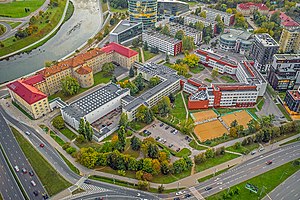
Vytautas Magnus University Education Academy
Distance: Approx. 507 meters
Latitude and longitude: 54.6968,25.2613
Vytautas Magnus University Education Academy (Lithuanian: Vytauto Didžiojo universiteto Švietimo akademija or VDU ŠA) – an academical unit of Vytautas Magnus University, which specialized in preparing school teachers and other educators. Located in Vilnius and Kaunas, Lithuania.
Jonas Mekas Visual Arts Center
Arts centre in Lithuania
Distance: Approx. 1014 meters
Latitude and longitude: 54.6925,25.26416667
The Jonas Mekas Visual Arts Center (Lithuanian: Jono Meko Vizualiųjų Menų Centras) is an avant-garde arts centre in Vilnius, Lithuania. The Jonas Mekas Visual Arts Center was opened on November 10, 2007, by acclaimed Lithuanian filmmaker Jonas Mekas. The premiere exhibition featured The Avant-Garde: From Futurism to Fluxus.

Lithuania National Stadium
Football stadium under construction in Lithuania
Distance: Approx. 797 meters
Latitude and longitude: 54.70833333,25.25777778
The Lithuania National Stadium (Lithuanian: Nacionalinis stadionas) is a multi-use stadium in Vilnius, Lithuania, which is under construction. It is planned mostly for football matches and is scheduled to host the home matches of the Lithuania national football team. It would replace the demolished Žalgiris Stadium and the current LFF Stadium as the main stadiums in Vilnius.
Vilnius Guggenheim Hermitage Museum
Lived in Lithuania
Distance: Approx. 997 meters
Latitude and longitude: 54.695011,25.27113
Vilnius Guggenheim Hermitage Museum was a proposed art museum in the city of Vilnius, the capital of Lithuania. On April 8, 2008, an international jury named Zaha Hadid, a British-Iraqi architect, the winner of the international design competition for the museum. The museum was initially scheduled to open in 2011.

Forum Palace
Indoor arena in Vilnius, Lithuania
Distance: Approx. 620 meters
Latitude and longitude: 54.69722222,25.26666667
Forum Palace is a commercial center and indoor arena in Vilnius. The arena is located near to the Vilnius financial centre in Konstitucija avenue. Forum Palace is often used to host music events and concerts.
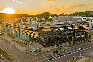
PLC Panorama
Shopping centre in Vilnius, Lithuania
Distance: Approx. 221 meters
Latitude and longitude: 54.7,25.2575
Panorama is the third largest shopping center in Vilnius and the seventh largest shopping mall in Lithuania with 65,000 m2 (700,000 sq ft). It is owned by UAB E.L.L. „Nekilnojamas Turtas“ (Group E.L.L. Real Estate). It was built by the Lithuanian company in 2008, in Saltoniškės.

Vilnius University of Applied Sciences
Lithuanian state institution of higher education
Distance: Approx. 612 meters
Latitude and longitude: 54.69611111,25.25694444
Vilnius University of Applied Sciences (Lithuanian: Vilniaus kolegija) or VIKO is a Lithuanian vocational university (kolegija), established on 1 September 2000 upon reorganizing three higher schools in Vilnius: Schools of Electronics, Economics and Commerce. It is the largest university of applied sciences in Lithuania, hosting 6,793 students and ~460 teaching staff (according to October 2015 data). Vilnius University of Applied Sciences is the best rated vocational university (kolegija) in Lithuania.

Konstitucijos Avenue
Distance: Approx. 887 meters
Latitude and longitude: 54.69722222,25.27194444
Konstitucijos Avenue (literally: Constitution Avenue; Lithuanian: Konstitucijos prospektas) is a major transport artery of Vilnius, the capital of Lithuania. It goes through Vilnius Central Business District where many corporates have their local or regional headquarters. Europa Tower, the tallest building in Lithuania, and Vilnius city municipality building are located on the Konstitucijos Avenue.

Ramailes Yeshiva
Pre-World War II yeshiva
Distance: Approx. 1015 meters
Latitude and longitude: 54.70194444,25.27583333
The Ramailes Yeshiva was an Orthodox Jewish yeshiva in Šnipiškės, Vilnius, Lithuania. It was established in the early nineteenth century, most likely in 1815.

Iron Wolf Bridge
Bridge in Vilnius, Lithuania
Distance: Approx. 713 meters
Latitude and longitude: 54.69527778,25.26388889
The Iron Wolf Bridge (Lithuanian: Geležinio vilko tiltas) is a bridge over the Neris River in Vilnius, Lithuania. Named after the legend of Iron Wolf, the bridge connects Naujamiestis with the districts of Žvėrynas and Šnipiškės, as the roundabout is situated at the administrative line.

Church of the Immaculate Conception of the Blessed Virgin Mary, Vilnius
Roman Catholic church in Vilnius, Lithuania built in 1925
Distance: Approx. 575 meters
Latitude and longitude: 54.69833333,25.25277778
Church of the Immaculate Conception of the Blessed Virgin Mary (Lithuanian: Švč. Mergelės Marijos Nekaltojo Prasidėjimo bažnyčia) is a Roman Catholic church in Žvėrynas, one of the neighborhoods of Vilnius, which was for the most part completed in 1925. The initial project of the church was only partly implemented as due to the Great Depression and World War II the towers of the church were not built.

Kurk Lietuvai
Lithuanian government programme
Distance: Approx. 673 meters
Latitude and longitude: 54.69527778,25.25916667
Kurk Lietuvai (in English: Create Lithuania), also known as KurkLT, is a strategic government initiative focused on fostering innovation and implementing best practices within the Lithuanian public sector. It is part of Invest Lithuania, country's foreign investment agency. This is the only program of its kind in Lithuania with few equivalents abroad.
Weather in this IP's area
clear sky
14 Celsius
14 Celsius
14 Celsius
15 Celsius
1025 hPa
72 %
1025 hPa
1012 hPa
10000 meters
2.06 m/s
130 degree
06:39:19
19:54:11