Country:
Region:
City:
Latitude and Longitude:
Time Zone:
Postal Code:
IP information under different IP Channel
ip-api
Country
Region
City
ASN
Time Zone
ISP
Blacklist
Proxy
Latitude
Longitude
Postal
Route
Luminati
Country
ASN
Time Zone
Europe/Berlin
ISP
Hetzner Online GmbH
Latitude
Longitude
Postal
IPinfo
Country
Region
City
ASN
Time Zone
ISP
Blacklist
Proxy
Latitude
Longitude
Postal
Route
db-ip
Country
Region
City
ASN
Time Zone
ISP
Blacklist
Proxy
Latitude
Longitude
Postal
Route
ipdata
Country
Region
City
ASN
Time Zone
ISP
Blacklist
Proxy
Latitude
Longitude
Postal
Route
Popular places and events near this IP address

Dortmund
City in North Rhine-Westphalia, Germany
Distance: Approx. 414 meters
Latitude and longitude: 51.51388889,7.46527778
Dortmund (German: [ˈdɔʁtmʊnt] ; Westphalian: Düörpm [ˈdyːœɐ̯pm̩]; Latin: Tremonia) is the third-largest city in North Rhine-Westphalia, after Cologne and Düsseldorf, and the ninth-largest city in Germany. With a population of 612,065 inhabitants, it is the largest city (by area and population) of the Ruhr as well as the largest city of Westphalia. It lies on the Emscher and Ruhr rivers (tributaries of the Rhine) in the Rhine-Ruhr Metropolitan Region, the second biggest metropolitan region by GDP in the European Union, and is considered the administrative, commercial, and cultural centre of the eastern Ruhr.
St. Reinold's Church, Dortmund
Church in Dortmund, Germany
Distance: Approx. 558 meters
Latitude and longitude: 51.51472222,7.4675
The Lutheran Protestant Church of St. Reinold (German: Reinoldikirche) is, according to its foundation date, the oldest extant church in Dortmund, Germany; it is dedicated to Reinold, also known as Renaud de Montauban, the patron of the city. The church was built as a palatine church in the Ottonian era.

Theater Dortmund
Theatre and opera company in Dortmund, Germany
Distance: Approx. 167 meters
Latitude and longitude: 51.51111111,7.46166667
Theater Dortmund is a theatrical organization that produces operas, musicals, ballets, plays, and concerts in Dortmund, Germany. It was founded as the Stadttheater Dortmund in 1904. Supported by the German Government, the organization owns and operates several performance spaces.

Opernhaus Dortmund
Opera house of Dortmund
Distance: Approx. 165 meters
Latitude and longitude: 51.511,7.4616
Opernhaus Dortmund is the opera house of Dortmund, Germany, operated by the Theater Dortmund organisation. A new opera house opened in 1966, replacing an earlier facility which opened in 1904 and was destroyed during World War II. It was built on the former site of the Old Synagogue, which was demolished by the Nazi local government in the 1930s. Architects Heinrich Rosskotten and Edgar Tritthart designed the modernist structure.

Adler Apotheke (Dortmund)
Pharmacy in Dortmund
Distance: Approx. 449 meters
Latitude and longitude: 51.51388889,7.46666667
The Adler Apotheke, in Dortmund, is the oldest existing pharmacy in its original location in North Rhine-Westphalia. The pharmacy is located in a historic building at the Adler Alter Markt in the heart of central Dortmund. Its existence was first documented in 1392 and was owned by the same family for over 500 years.

Dortmund Stadthaus station
Railway station in Dortmund, Germany
Distance: Approx. 455 meters
Latitude and longitude: 51.50784,7.46895
Dortmund Stadthaus station is an important railway station of the inner city of Dortmund in the German state of North Rhine-Westphalia. It is located in the inner city at the junction of Ruhrallee (B54) and Märkischen Straße, near the Stadthaus, a municipal office building. It is classified by Deutsche Bahn as a category 5 station.

Altes Stadthaus, Dortmund
German office block built in 1899
Distance: Approx. 260 meters
Latitude and longitude: 51.51111111,7.46722222
Altes Stadthaus in Dortmund, North Rhine-Westphalia, Germany, is an office block which was built in 1899, and was designed by "master builder" Friedrich Kullrich (a German architect, urban planner and construction officer from Berlin). It was built in the Renaissance Revival architecture (Neo-Renaissance) style. After the office block was severely damaged in World War II, it was rebuilt in a simplified form.

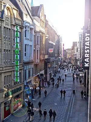
Westenhellweg
Distance: Approx. 499 meters
Latitude and longitude: 51.5144,7.4608
Westenhellweg is the main shopping street in Dortmund, Germany. With nearly 13,000 visitors per hour it was Germany's most frequented shopping street in 2013.

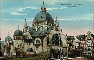
Old Synagogue (Dortmund)
Synagogue in Dortmund, North Rhine-Westfalia, Germany
Distance: Approx. 149 meters
Latitude and longitude: 51.5108,7.4617
The Old Synagogue (German: Alte Synagoge) was a former Jewish congregation and synagogue, located in Dortmund, in the state of North Rhine-Westphalia, Germany. Completed in 1900, the synagogue was abandoned in 1933 and demolished in 1938. Prior to its abandonment, the synagogue was the largest synagogue and cultural center of the Jewish community in Dortmund.

Marienkirche, Dortmund
Church in North Rhine-Westphalia, Germany
Distance: Approx. 508 meters
Latitude and longitude: 51.5142,7.4675
Marienkirche (St. Mary's Church) is a church in Dortmund, North Rhine-Westphalia state, Germany, located in the inner city. Since the Reformation, it has been a Lutheran parish church of St.

Propsteikirche, Dortmund
Church in North Rhine-Westphalia, Germany
Distance: Approx. 374 meters
Latitude and longitude: 51.51361111,7.46277778
Propsteikirche is the common name of a church in Dortmund, North Rhine-Westphalia, Germany, the only Catholic church in the city centre. The full name is Propsteikirche St. Johannes Baptist Dortmund.

St. Peter's Church, Dortmund
Church in Dortmund, Germany
Distance: Approx. 536 meters
Latitude and longitude: 51.51465,7.46038
St. Peter's Church in Dortmund, Westphalia, Germany, is an urban hall church in the High Gothic style. The central nave and side aisles are of the same height, coming close to the ideal type of this church form.
Weather in this IP's area
clear sky
6 Celsius
4 Celsius
5 Celsius
7 Celsius
1032 hPa
87 %
1032 hPa
1018 hPa
10000 meters
2.57 m/s
70 degree
07:25:53
17:01:26
