Country:
 Germany
Region:
City:
Latitude and Longitude:
Time Zone:
Postal Code:
IP information under different IP Channel
ip-api
Country
Region
City
ASN
Time Zone
ISP
Blacklist
Proxy
Latitude
Longitude
Postal
Route
IPinfo
Country
Region
City
ASN
Time Zone
ISP
Blacklist
Proxy
Latitude
Longitude
Postal
Route
MaxMind
Country
Region
City
ASN
Time Zone
ISP
Blacklist
Proxy
Latitude
Longitude
Postal
Route
Luminati
Country
DERegion
nw
City
burbach
ASN
Time Zone
Europe/Berlin
ISP
Hetzner Online GmbH
Latitude
Longitude
Postal
db-ip
Country
Region
City
ASN
Time Zone
ISP
Blacklist
Proxy
Latitude
Longitude
Postal
Route
ipdata
Country
Region
City
ASN
Time Zone
ISP
Blacklist
Proxy
Latitude
Longitude
Postal
Route
Popular places and events near this IP address
Avanti Air
German airline
Distance: Approx. 5453 meters
Latitude and longitude: 50.70531,8.073852
Avanti Air GmbH & Co. KG, styled as avantiair, is a small German airline based in Burbach with a maintenance base at Siegerland Airport, operating ad hoc charter and aircraft wet-lease services.

Siegerland Airport
Airport in Burbach
Distance: Approx. 5177 meters
Latitude and longitude: 50.70777778,8.08305556
Siegerland Airport (IATA: SGE, ICAO: EDGS) or Siegerlandflughafen in German is a small regional airport in Burbach in the Siegerland region near Siegen, Germany. It was formerly served by the Scheuerfeld–Emmerzhausen railway and is presently used as the maintenance base for Avanti Air.

Emmerzhausen
Municipality in Rhineland-Palatinate, Germany
Distance: Approx. 5310 meters
Latitude and longitude: 50.72055556,8.02527778
Emmerzhausen is a municipality in the district of Altenkirchen, in Rhineland-Palatinate, Germany.

Burbach, North Rhine-Westphalia
Municipality in North Rhine-Westphalia, Germany
Distance: Approx. 1205 meters
Latitude and longitude: 50.74444444,8.08611111
Burbach is a municipality in the Siegen-Wittgenstein district, in North Rhine-Westphalia, Germany.
Bachseifen
River of North Rhine-Westphalia, Germany
Distance: Approx. 2641 meters
Latitude and longitude: 50.7575,8.11583333
Bachseifen is a small river of North Rhine-Westphalia, Germany. It flows into the Heller near Burbach.

Buchheller
River in Germany
Distance: Approx. 1361 meters
Latitude and longitude: 50.7588,8.0608
Buchheller is a river of North Rhine-Westphalia, Germany. It flows into the Heller near Burbach.

Gilsbach
River in Germany
Distance: Approx. 2012 meters
Latitude and longitude: 50.7643,8.055
Gilsbach is a small river of North Rhine-Westphalia, Germany. It flows into the Heller near Burbach.
Volkersbach
River in Germany
Distance: Approx. 4035 meters
Latitude and longitude: 50.7807,8.0396
Volkersbach is a small river of North Rhine-Westphalia, Germany. It flows into the Heller near Neunkirchen.

Wiebelhäuser Bach
River in Germany
Distance: Approx. 4485 meters
Latitude and longitude: 50.7909,8.105
Wiebelhäuser Bach is a small river of North Rhine-Westphalia, Germany. It is a left tributary of the Wildenbach near Wilnsdorf.

Trödelsteine (mountain)
Mountain in Germany
Distance: Approx. 4103 meters
Latitude and longitude: 50.72836111,8.03716667
The Trödelsteine is the name of a mountain, 613 m above sea level (NHN), in the Heller Upland near Emmerzhausen in the county of Altenkirchen in the German state of Rhineland-Palatinate and the county of Siegen-Wittgenstein in the state of North Rhine-Westphalia with its summit area in Rhineland-Palatinate.
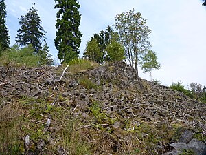
Trödelsteine (rock formation)
Distance: Approx. 4103 meters
Latitude and longitude: 50.72836111,8.03716667
The Trödelsteine, also called the Trödelstein, is a rock formation near Emmerzhausen in the county of Altenkirchen in the German state of Rhineland-Palatinate. It consists of columnar basalt and a basaltic blockfield in the Heller Upland. The rock formation has been designated as a natural monument, about 0.3 hectares in area.

Gutenbach (Wildenbach)
River in Germany
Distance: Approx. 5851 meters
Latitude and longitude: 50.795,8.0263
Gutenbach is a river of North Rhine-Westphalia, Germany. It springs north of Unterwilden, a district of Wilnsdorf. It is a right tributary of the Wildenbach in Salchendorf, a district of Neunkirchen.
Weather in this IP's area
overcast clouds
11 Celsius
10 Celsius
10 Celsius
12 Celsius
1023 hPa
94 %
1023 hPa
975 hPa
10000 meters
3.09 m/s
320 degree
100 %
07:05:06
19:40:00