188.30.18.86 - IP Lookup: Free IP Address Lookup, Postal Code Lookup, IP Location Lookup, IP ASN, Public IP
Country:
 Great Britain
Region:
City:
Location:
Time Zone:
Postal Code:
ISP:
ASN:
language:
User-Agent:
Proxy IP:
Blacklist:
IP information under different IP Channel
ip-api
Country
Region
City
ASN
Time Zone
ISP
Blacklist
Proxy
Latitude
Longitude
Postal
Route
db-ip
Country
Region
City
ASN
Time Zone
ISP
Blacklist
Proxy
Latitude
Longitude
Postal
Route
IPinfo
Country
Region
City
ASN
Time Zone
ISP
Blacklist
Proxy
Latitude
Longitude
Postal
Route
IP2Location
188.30.18.86Country
gbRegion
scotland
City
fetteresso
Time Zone
Europe/London
ISP
Language
User-Agent
Latitude
Longitude
Postal
ipdata
Country
Region
City
ASN
Time Zone
ISP
Blacklist
Proxy
Latitude
Longitude
Postal
Route
Popular places and events near this IP address

Stonehaven
Town in Aberdeenshire, Scotland
Distance: Approx. 2064 meters
Latitude and longitude: 56.964,-2.211
Stonehaven ( stohn-HAY-vən) is a town on the northeast coast of Scotland, 15 miles (24 km) south of Aberdeen. It had a population of 11,177 at the 2022 Census. Stonehaven was formerly the county town of Kincardineshire, succeeding the now abandoned town of Kincardine.
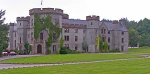
Fetteresso Castle
Scottish estate
Distance: Approx. 2012 meters
Latitude and longitude: 56.9604,-2.2604
Fetteresso Castle is a 14th-century tower house, rebuilt in 1761 as a Scottish Gothic style Palladian manor, with clear evidence of prehistoric use of the site. It is situated immediately west of the town of Stonehaven in Kincardineshire, slightly to the west of the A90 dual carriageway. Other notable historic fortified houses or castles in this region are Dunnottar Castle, Muchalls Castle, Fiddes Castle, Cowie Castle and Monboddo House.

Stonehaven railway station
Railway station in Aberdeenshire, Scotland
Distance: Approx. 1917 meters
Latitude and longitude: 56.9667,-2.2256
Stonehaven railway station serves the town of Stonehaven in Aberdeenshire, Scotland, United Kingdom. It is sited 224 miles 74 chains (362.0 kilometres) from Carlisle via Perth, on the Dundee to Aberdeen line, and is situated between Laurencekirk and Portlethen. There is a crossover at the southern end of the station, which can be used to facilitate trains turning back if the line towards Aberdeen is blocked.

Carron Water, Aberdeenshire
River in Scotland
Distance: Approx. 2164 meters
Latitude and longitude: 56.96252,-2.20602
The Carron Water is a river in Kincardineshire, Scotland.

Kirktown of Fetteresso
Well-preserved village near Stonehaven, Scotland
Distance: Approx. 1583 meters
Latitude and longitude: 56.96361111,-2.24083333
The Kirktown of Fetteresso is a well-preserved village near Stonehaven, Scotland. In the planning area of Kincardine and Mearns, Aberdeenshire, this village contains many very old stone residential structures as well as the Church of St. Ciarans and its associated graveyard.

Red Cloak
Industrial area in Scotland
Distance: Approx. 1672 meters
Latitude and longitude: 56.965,-2.232
Red Cloak is an industrial area of Stonehaven, Aberdeenshire, Scotland. The site's settlement history is associated with events at the nearby Chapel of St. Mary and St.

Dunnottar Parish Church
Church in the south of Aberdeenshire, Scotland
Distance: Approx. 949 meters
Latitude and longitude: 56.9578,-2.227
Dunnottar Parish Church is a parish church of the Church of Scotland, serving Stonehaven in the south of Aberdeenshire, Scotland. It is within the Church of Scotland's Presbytery of Kincardine and Deeside. During 2020, the congregation united to the South Parish Church in Stonehaven to form Carronside Church of Scotland.

Woodcot Hospital
Hospital in Scotland
Distance: Approx. 1458 meters
Latitude and longitude: 56.9615,-2.2218
Woodcot Hospital was a health facility in Woodcot Brae, Stonehaven, Scotland. It is a Category B listed building.

Stonehaven Sheriff Court
Judicial building in Stonehaven, Scotland
Distance: Approx. 1964 meters
Latitude and longitude: 56.9614,-2.2086
Stonehaven Sheriff Court, formerly known as County Buildings, is a judicial structure in Dunnottar Avenue, Stonehaven, Aberdeenshire, Scotland. The structure, which was used as the headquarters of Kincardineshire County Council as well as a courthouse, is a Category B listed building.

White Bridge (Stonehaven)
Bridge in Stonehaven
Distance: Approx. 1995 meters
Latitude and longitude: 56.962875,-2.21043889
The White Bridge is a footbridge in Stonehaven, Scotland. It was constructed in 1879. It was built with a wooden floor which was replaced with concrete in 1892.

Stonehaven War Memorial
Building
Distance: Approx. 1940 meters
Latitude and longitude: 56.95497778,-2.20266944
Stonehaven War Memorial is a war memorial situated on Black Hill overlooking Stonehaven in Scotland.

Stonehaven Town House
Municipal building in Stonehaven, Scotland
Distance: Approx. 2132 meters
Latitude and longitude: 56.9608,-2.2043
Stonehaven Town House, also known as the Clock Tower and the Old Town Steeple, is a former municipal building on the High Street in Stonehaven in Aberdeenshire in Scotland. The building, which was previously the meeting place of the burgh council, is a Category B listed building.
Weather in this IP's area
overcast clouds
4 Celsius
-0 Celsius
4 Celsius
5 Celsius
1029 hPa
94 %
1029 hPa
1017 hPa
10000 meters
6.51 m/s
9.14 m/s
94 degree
100 %