Country:
Region:
City:
Latitude and Longitude:
Time Zone:
Postal Code:
IP information under different IP Channel
ip-api
Country
Region
City
ASN
Time Zone
ISP
Blacklist
Proxy
Latitude
Longitude
Postal
Route
Luminati
Country
Region
vo
City
ruma
ASN
Time Zone
Europe/Belgrade
ISP
Orion Telekom Tim d.o.o.Beograd
Latitude
Longitude
Postal
IPinfo
Country
Region
City
ASN
Time Zone
ISP
Blacklist
Proxy
Latitude
Longitude
Postal
Route
db-ip
Country
Region
City
ASN
Time Zone
ISP
Blacklist
Proxy
Latitude
Longitude
Postal
Route
ipdata
Country
Region
City
ASN
Time Zone
ISP
Blacklist
Proxy
Latitude
Longitude
Postal
Route
Popular places and events near this IP address
Ruma
Town and municipality in Vojvodina, Serbia
Distance: Approx. 1293 meters
Latitude and longitude: 45,19.83333333
Ruma (Serbian Cyrillic: Рума; Hungarian: Árpatarló) is a town and municipality in the Srem District of the Autonomous Province of Vojvodina, Serbia. As of 2022, the town has a population of 27,747, while the municipality has a population of 48,621.

Aux Manir
Contemporary art group from Serbia
Distance: Approx. 54 meters
Latitude and longitude: 45.00814,19.82208
Aux Maniere, later AUX Manir Slobodan Sajin was a contemporary art group from Serbia in 1982-2009, established by Slobodan Šajin (1952–2009) and Momčilo Rajin (1954).

Žarkovac (Ruma)
Village in Vojvodina, Serbia
Distance: Approx. 8866 meters
Latitude and longitude: 45.00361111,19.93472222
Žarkovac (Serbian Cyrillic: Жарковац) is a village in Serbia. It is situated in the Ruma municipality, in the Srem District, Vojvodina province. The village has a Serb ethnic majority and its population numbering 1,102 people (2002 census).

Mali Radinci
Village in Vojvodina, Serbia
Distance: Approx. 6180 meters
Latitude and longitude: 45.01666667,19.9
Mali Radinci (Serbian Cyrillic: Мали Радинци) is a village in Serbia. It is situated in the Ruma municipality, in the Srem District, Vojvodina province. The village has a Serb ethnic majority and its population numbering 598 people (2002 census).
Šašinci
Village in Vojvodina, Serbia
Distance: Approx. 7362 meters
Latitude and longitude: 44.96666667,19.75
Šašinci (Serbian Cyrillic: Шашинци) is a village in Serbia. It is located in the Sremska Mitrovica municipality, in the Srem District, Vojvodina province. The village has a Serb ethnic majority and its population numbering 1,830 people (2002 census).
Voganj
Village in Vojvodina, Serbia
Distance: Approx. 5771 meters
Latitude and longitude: 45,19.75
Voganj (Serbian Cyrillic: Вогањ) is a village in Serbia. It is situated in the Ruma municipality, in the Srem District, Vojvodina province. The village has the population of 1,506 (2011 census).
Rivica
Village in Vojvodina, Serbia
Distance: Approx. 8364 meters
Latitude and longitude: 45.08333333,19.83333333
Rivica (Serbian Cyrillic: Ривица) is a village in Serbia. It is situated in the Irig municipality, in the Srem District, Vojvodina province. The village has a Serb ethnic majority and its population numbering 657 people (2002 census).

Kraljevci, Ruma
Village in Vojvodina, Serbia
Distance: Approx. 5567 meters
Latitude and longitude: 44.98333333,19.88333333
Kraljevci (Serbian Cyrillic: Краљевци) is a village in Serbia. It is situated in the Ruma municipality, in the Srem District, Vojvodina province. The village has a Serb ethnic majority and its population numbering 1,232 people (2002 census).

Pavlovci, Serbia
Village in Vojvodina, Serbia
Distance: Approx. 5639 meters
Latitude and longitude: 45.0522,19.7858
Pavlovci (Serbian Cyrillic: Павловци) is a village located in the municipality of Ruma, Vojvodina, Serbia. As of 2011 census, it has a population of 393 inhabitants.
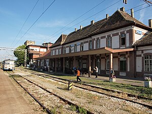
Ruma railway station
Railway station in Serbia
Distance: Approx. 2167 meters
Latitude and longitude: 44.98944444,19.82722222
Ruma railway station (Serbian: Железничка станица Рума) is a railway station on Belgrade–Šid, first on Ruma–Zvornik railway and railway junction. Located in Ruma, Serbia. Railroad continued to Voganj in one, in the other direction to Putinci and the third direction towards to Buđanovci.
Voganj railway station
Railway station in Serbia
Distance: Approx. 8460 meters
Latitude and longitude: 44.98861111,19.71861111
Voganj railway station (Serbian: Железничка станица Вогањ) is a railway station on Belgrade–Šid railway. Located in Voganj, Ruma, Serbia. Railroad continued to Sremska Mitrovica in one and the other direction to Ruma.

Church of the Transfiguration of the Lord, Ruma
A church in Serbia
Distance: Approx. 566 meters
Latitude and longitude: 45.00555556,19.82805556
The Church of the Transfiguration of the Lord (Serbian: Црква вазнесења Господњег) in Ruma is Serbian Orthodox church in Vojvodina, Serbia.
Weather in this IP's area
broken clouds
2 Celsius
-1 Celsius
1 Celsius
3 Celsius
1026 hPa
79 %
1026 hPa
1012 hPa
10000 meters
3.14 m/s
6.33 m/s
270 degree
84 %
06:38:48
16:12:08


