Country:
Region:
City:
Latitude and Longitude:
Time Zone:
Postal Code:
IP information under different IP Channel
ip-api
Country
Region
City
ASN
Time Zone
ISP
Blacklist
Proxy
Latitude
Longitude
Postal
Route
Luminati
Country
Region
zh
City
zurich
ASN
Time Zone
Europe/Zurich
ISP
HOSTHATCH
Latitude
Longitude
Postal
IPinfo
Country
Region
City
ASN
Time Zone
ISP
Blacklist
Proxy
Latitude
Longitude
Postal
Route
db-ip
Country
Region
City
ASN
Time Zone
ISP
Blacklist
Proxy
Latitude
Longitude
Postal
Route
ipdata
Country
Region
City
ASN
Time Zone
ISP
Blacklist
Proxy
Latitude
Longitude
Postal
Route
Popular places and events near this IP address

Raetia
Roman province
Distance: Approx. 1058 meters
Latitude and longitude: 47.36,8.56
Raetia or Rhaetia ( REE-sh(ee-)ə, Latin: [ˈrae̯.ti.a]) was a province of the Roman Empire named after the Rhaetian people. It bordered on the west with the country of the Helvetii, on the east with Noricum, on the north with Vindelicia, on the south-west with Transalpine Gaul and on the south with Venetia et Histria, a region of Roman Italy. It thus comprised the districts occupied in modern times by eastern and central Switzerland (containing the Upper Rhine and Lake Constance), southern Germany (Bavaria and most of Baden-Württemberg), Vorarlberg and the greater part of Tyrol in Austria, and part of northern Lombardy in Italy.

Fluntern
Distance: Approx. 1020 meters
Latitude and longitude: 47.376,8.56
Fluntern is a quarter in the district 7 in Zürich, Switzerland. It was formerly a municipality of its own, having been incorporated into Zürich in 1893. The quarter has a population of 7,325 distributed on an area of 2.84 km2.

Hirslanden
Distance: Approx. 401 meters
Latitude and longitude: 47.36464444,8.56628333
Hirslanden is a quarter in the district 7 in Zürich. It was formerly a municipality of its own, having been incorporated into Zürich in 1893. The quarter has a population of 6,859 distributed on an area of 2.2 km2 (0.85 sq mi).
Hottingen (Zürich)
Quarter of the city of Zurich, Switzerland
Distance: Approx. 505 meters
Latitude and longitude: 47.36811944,8.5604
Hottingen is a quarter in District 7 in Zürich. It was formerly a municipality of its own, but was incorporated into Zürich in 1893. The quarter has a population of 10,100 in an area of 5.05 square kilometres (1.95 sq mi).

Mühlebach (Zürich)
Distance: Approx. 1179 meters
Latitude and longitude: 47.36152222,8.55496944
Mühlebach is a quarter in the district 8 of Zürich. It was part of Riesbach municipality that was incorporated into Zürich in 1893. The quarter has a population of 5,577 distributed on an area of 0.63 km2 (0.24 sq mi).

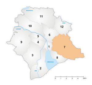
District 7 (Zürich)
District in Zürich, Switzerland
Distance: Approx. 1110 meters
Latitude and longitude: 47.373,8.58
District 7 is a district east of the old town in the Swiss city of Zürich. The district comprises the quarters Fluntern, Hottingen, Hirslanden and Witikon. All entities were formerly municipalities of their own, but were incorporated into Zürich in 1893 (Witikon in 1934).

Dolder Grand
Hotel in Zurich, Switzerland
Distance: Approx. 688 meters
Latitude and longitude: 47.3728,8.5732
The Dolder Grand (formerly known as Grand Hotel Dolder) is a 5-star superior hotel in the Swiss city of Zurich. It is located on Adlisberg hill, some 2 kilometres (1.2 mi) from, and 200 metres (660 ft) above, the city centre. Built in 1899, the hotel spreads out over 40,000 square metres (430,000 sq ft) and offers 173 rooms and suites, two restaurants, a bar, 13 conference rooms and a 4,000-square-metre (43,000 sq ft) spa.

Weinegg
Quarter of the city of Zurich, Switzerland
Distance: Approx. 1140 meters
Latitude and longitude: 47.35805556,8.565
Weinegg is a quarter in District 8 of Zürich.

Dolderbahn
Rack railway in the Swiss city of Zurich
Distance: Approx. 438 meters
Latitude and longitude: 47.372132,8.566792
The Dolderbahn (Db or DBZ) is a 1.3 km (0.81 mi) long rack railway in the Swiss city of Zürich. The line is in Zürich's Hottingen and Fluntern suburbs on the south slope of the Adlisberg mountain. The lower terminus of the line is at Römerhof, some 1.5 km (0.93 mi) from the city centre, where it connects with lines 3 and 8 of the Zürich tramway.

Botanical Garden of the University of Zurich
Distance: Approx. 1172 meters
Latitude and longitude: 47.358566,8.560817
The Botanical Garden of the University of Zurich (German: Botanischer Garten der Universität Zürich) is a botanical garden in the Swiss city of Zurich. It was opened in 1977 and is located at Zollikerstrasse in the Weinegg quarter of the city. The garden should not be mistaken for the Old Botanical Garden, located on the former zur Katz bastion in the city centre, which is also owned by the University of Zurich.

Zürichberg Tunnel
Railway tunnel in Zürich, Switzerland
Distance: Approx. 817 meters
Latitude and longitude: 47.3657128,8.5569026
The Zürichberg Tunnel (German: Zürichbergtunnel) is a railway tunnel in the Swiss city of Zürich. The tunnel runs from a junction with the Lake Zürich right bank line at Zürich Stadelhofen station, to Stettbach railway station. It passes under the Zürichberg range of hills that separates Zürich city centre from the Glattal region.

Doldertal Apartment Houses
Residential building in Zürich, Switzerland
Distance: Approx. 642 meters
Latitude and longitude: 47.37305556,8.5625
The Doldertal Apartment Houses (German: Mehrfamilienhäuser Doldertal) are a group of modern apartment buildings in Doldertal, a suburb of Zürich on the slope of the Adlisberg mountain. The buildings were designed by architects Alfred Roth, Emil Roth, and reviewed by Marcel Breuer. They were built in 1936.
Weather in this IP's area
overcast clouds
4 Celsius
2 Celsius
3 Celsius
8 Celsius
1021 hPa
85 %
1021 hPa
963 hPa
8000 meters
2.57 m/s
140 degree
100 %
07:32:08
16:49:15
