188.239.250.255 - IP Lookup: Free IP Address Lookup, Postal Code Lookup, IP Location Lookup, IP ASN, Public IP
Country:
Region:
City:
Location:
Time Zone:
Postal Code:
IP information under different IP Channel
ip-api
Country
Region
City
ASN
Time Zone
ISP
Blacklist
Proxy
Latitude
Longitude
Postal
Route
Luminati
Country
Region
14
City
sloviansk
ASN
Time Zone
Europe/Kyiv
ISP
Satellite Net Service LLC
Latitude
Longitude
Postal
IPinfo
Country
Region
City
ASN
Time Zone
ISP
Blacklist
Proxy
Latitude
Longitude
Postal
Route
IP2Location
188.239.250.255Country
Region
donetska oblast
City
sloviansk
Time Zone
Europe/Kiev
ISP
Language
User-Agent
Latitude
Longitude
Postal
db-ip
Country
Region
City
ASN
Time Zone
ISP
Blacklist
Proxy
Latitude
Longitude
Postal
Route
ipdata
Country
Region
City
ASN
Time Zone
ISP
Blacklist
Proxy
Latitude
Longitude
Postal
Route
Popular places and events near this IP address

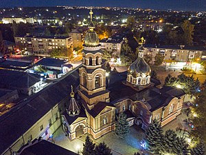
Sloviansk
City in Donetsk Oblast, Ukraine
Distance: Approx. 1607 meters
Latitude and longitude: 48.85333333,37.625
Sloviansk is a city in Donetsk Oblast, northern part of the Donbas region of eastern Ukraine. The city was known as Tor until 1784. While it did not actually belong to the raion itself, Sloviansk served as the administrative center of the Sloviansk Raion (district) until its abolition on 18 July 2020.

Siege of Sloviansk
2014 siege during the Donbas war
Distance: Approx. 710 meters
Latitude and longitude: 48.87,37.625
The siege of Sloviansk was conducted by Ukraine between 12 April 2014 and 5 July 2014. It began immediately after Sloviansk was seized by the separatist group, the Donetsk People's Republic, which, having received support from Russia, declared itself independent from Ukraine on 7 April. Following three months of heavy fighting between the Armed Forces of Ukraine and the DPR People's Militia, the Ukrainian government retook the city as the pro-Russia rebels retreated to Donetsk.
Sukhanivka, Donetsk Oblast
Rural locality in Donetsk Oblast, Ukraine
Distance: Approx. 7988 meters
Latitude and longitude: 48.82111111,37.5325
Sukhanivka (Ukrainian: Суханівка), previously known as Andriivka (Ukrainian: Андріївка) between 1938 and 2024, is a rural settlement (a selyshche) in Kramatorsk Raion, Donetsk Oblast, eastern Ukraine. It is subordinate to Sloviansk urban hromada, one of the hromadas of Ukraine. It has a population of 833 (2022 estimate).

Bylbasivka
Urban locality in Donetsk Oblast, Ukraine
Distance: Approx. 9195 meters
Latitude and longitude: 48.83972222,37.49805556
Bylbasivka (Ukrainian: Билбасівка) is a rural settlement in Kramatorsk Raion, Donetsk Oblast, eastern Ukraine. Population: 5,807 (2022 estimate).
Raihorodok
Urban locality in Donetsk Oblast, Ukraine
Distance: Approx. 8691 meters
Latitude and longitude: 48.90027778,37.72388889
Raihorodok (Ukrainian: Райгородок) is a rural settlement in Kramatorsk Raion, Donetsk Oblast, eastern Ukraine. It is located near the Kazennyi Torets and Donets Rivers. Population: 3,166 (2022 estimate).
Donetske, Donetsk Oblast
Urban locality in Donetsk Oblast, Ukraine
Distance: Approx. 9303 meters
Latitude and longitude: 48.93472222,37.69055556
Donetske (Ukrainian: Донецьке) is a rural settlement in Kramatorsk Raion, Donetsk Oblast, eastern Ukraine. It belongs to Mykolaivka urban hromada, one of the hromadas of Ukraine. Population: 574 (2022 estimate).
Seleznivka, Donetsk Oblast
Village in Donetsk Oblast, Ukraine
Distance: Approx. 3826 meters
Latitude and longitude: 48.86277778,37.66861111
Seleznivka (Ukrainian: Селезнівка) is a village in Kramatorsk Raion of Donetsk Oblast, Ukraine. It forms part of Mykolaivka urban hromada, one of the hromadas of Ukraine. Until 18 July 2020, Seleznivka was located in Sloviansk Raion.

April 2023 Sloviansk airstrike
14 April 2023 missile strike during the Russian invasion of Ukraine
Distance: Approx. 1607 meters
Latitude and longitude: 48.85333333,37.625
On 14 April 2023, on Eastern Orthodox Christian Good Friday, a Russian missile strike struck residential buildings in Sloviansk, Ukraine, during the Russian invasion of Ukraine. 15 civilians were killed and 24 were injured. 34 apartment buildings, administrative buildings, and shops were damaged in the blasts.

Karpivka, Mykolaivka urban hromada, Kramatorsk Raion, Donetsk Oblast
Village in Donetsk Oblast, Ukraine
Distance: Approx. 4052 meters
Latitude and longitude: 48.89694444,37.6475
Karpivka (Ukrainian: Карпівка; Russian: Карповка) is a village in Kramatorsk Raion (district) in Donetsk Oblast of eastern Ukraine. It belongs to Mykolaivka settlement hromada, one of the hromadas of Ukraine. Until 18 July 2020, Karpivka belonged to Sloviansk Raion.

Maiaky, Donetsk Oblast
Selo in Donetsk Oblast, Ukraine
Distance: Approx. 8850 meters
Latitude and longitude: 48.94611111,37.6225
Maiaky (Ukrainian: Мая́ки) is a village in eastern Ukraine, located in Kramatorsk Raion, Donetsk Oblast. It is located in Sviatohirsk urban hromada. Maiaky was a part of the administrative municipality of Maiaky, however it was abolished in 12 June 2020 as part of the July 2020 Ukrainian administrative reform.
Sukhyi Torets
Distance: Approx. 5530 meters
Latitude and longitude: 48.81892,37.59603
The Sukhyi Torets (Ukrainian: Сухий Торець) is a river in eastern Ukraine. It is a tributary of the Seversky Donets.

Sloviansk railway station
Main railway station in the Ukrainian city of Sloviansk
Distance: Approx. 5863 meters
Latitude and longitude: 48.8325,37.55583333
The Sloviansk railway station (Ukrainian: Станція Слов'янськ) is the main railway station in the Ukrainian city of Sloviansk. It first opened in 1869, and is currently operated by Donets Railway.
Weather in this IP's area
overcast clouds
4 Celsius
0 Celsius
4 Celsius
4 Celsius
1020 hPa
92 %
1020 hPa
1013 hPa
10000 meters
5.48 m/s
13.44 m/s
185 degree
89 %
