Country:
Region:
City:
Latitude and Longitude:
Time Zone:
Postal Code:
IP information under different IP Channel
ip-api
Country
Region
City
ASN
Time Zone
ISP
Blacklist
Proxy
Latitude
Longitude
Postal
Route
Luminati
Country
Region
sv
City
falticeni
ASN
Time Zone
Europe/Bucharest
ISP
Vodafone Romania S.A.
Latitude
Longitude
Postal
IPinfo
Country
Region
City
ASN
Time Zone
ISP
Blacklist
Proxy
Latitude
Longitude
Postal
Route
db-ip
Country
Region
City
ASN
Time Zone
ISP
Blacklist
Proxy
Latitude
Longitude
Postal
Route
ipdata
Country
Region
City
ASN
Time Zone
ISP
Blacklist
Proxy
Latitude
Longitude
Postal
Route
Popular places and events near this IP address

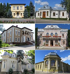
Fălticeni
Municipality in Suceava, Romania
Distance: Approx. 1506 meters
Latitude and longitude: 47.45972222,26.3
Fălticeni (Romanian pronunciation: [fəltiˈt͡ʃenʲ]; German: Foltischeni; Hungarian: Falticsén; Hebrew: פלטיצ'ן Yiddish: פאלטישאן) is a town in Suceava County, northeastern Romania. It is situated in the historical region of Western Moldavia. According to the 2021 census, Fălticeni is the third largest urban settlement in the county.

Battle of Baia
1467 battle between Moldavia and Hungary
Distance: Approx. 6021 meters
Latitude and longitude: 47.425,26.229
The Battle of Baia (Romanian: Bătălia de la Baia; Hungarian: moldvabányai csata) was fought on December 15, 1467, between Moldavian prince Stephen the Great and the Hungarian king, Matthias Corvinus. Corvinus invaded Moldavia as a consequence of Stephen's annexation of Chilia—a fortress and harbour on the coast of the Black Sea—from Hungarian and Wallachian forces. It had belonged to Moldavia centuries earlier.

Baia
Commune in Suceava, Romania
Distance: Approx. 7066 meters
Latitude and longitude: 47.4203,26.2169
Baia (German: Baja, Stadt Molde, or Moldenmarkt; Hungarian: Moldvabánya; Latin: Civitas Moldaviae) is a commune in Suceava County, in the historical region of Western Moldavia, northeastern Romania with a population of 6,793 (2002 census). It is composed of two villages, namely Baia and Bogata. Located on the Moldova River, it was one of the earliest urban settlements in Moldavia.
Târgul
River in Suceava County, Romania
Distance: Approx. 3167 meters
Latitude and longitude: 47.4608,26.3387
The Târgul is a right tributary of the river Șomuzul Mare in Romania. It crosses the city of Fălticeni. Its length is 7 km (4.3 mi) and its basin size is 12 km2 (4.6 sq mi).

Râșca (Moldova)
River in Suceava, Romania
Distance: Approx. 7443 meters
Latitude and longitude: 47.3823,26.3311
The Râșca is a right tributary of the river Moldova in Romania. It discharges into the Moldova near Praxia. Its length is 35 km (22 mi) and its basin size is 217 km2 (84 sq mi).

Vadu Moldovei
Commune in Suceava, Romania
Distance: Approx. 8514 meters
Latitude and longitude: 47.38333333,26.36666667
Vadu Moldovei is a commune located in Suceava County, Western Moldavia, Romania. It is composed of eight villages: Cămârzani, Ciumulești, Dumbrăvița, Ioneasa, Mesteceni, Movileni, Nigotești, and Vadu Moldovei. It included four other villages until 2003, when these were split off to form Fântâna Mare Commune.

Bogdănești, Suceava
Commune in Suceava, Romania
Distance: Approx. 8982 meters
Latitude and longitude: 47.36666667,26.28333333
Bogdănești is a commune located in Suceava County, Romania. It is composed of a single village, Bogdănești.

Bunești, Suceava
Commune in Suceava, Romania
Distance: Approx. 7905 meters
Latitude and longitude: 47.51666667,26.31666667
Bunești (German: Bunestie) is a commune located in Suceava County, Bukovina, northeastern Romania. It is composed of five villages: namely Bunești, Petia, Podeni, Șes, and Uncești.

Fântâna Mare
Commune in Suceava, Romania
Distance: Approx. 3304 meters
Latitude and longitude: 47.41666667,26.3
Fântâna Mare is a commune located in Suceava County, Romania. It is composed of four villages: Cotu Băii, Fântâna Mare, Praxia, and Spătărești. These were part of Vadu Moldovei Commune until 2003, when they were split off.

Hârtop, Suceava
Commune in Suceava, Romania
Distance: Approx. 6349 meters
Latitude and longitude: 47.48333333,26.36666667
Hârtop is a commune located in Suceava County, Romania. It is composed of a single village, Hârtop, that was part of Preutești commune until 2004.

Preutești
Commune in Suceava, Romania
Distance: Approx. 8604 meters
Latitude and longitude: 47.45,26.41666667
Preutești is a commune located in Suceava County, Romania. It is composed of six villages: Arghira, Basarabi, Bahna-Arin, Huși, Leucușești and Preutești. It also included the village of Hiartop until 2004, when it was split off to form a separate commune.

Rădășeni
Commune in Suceava, Romania
Distance: Approx. 4556 meters
Latitude and longitude: 47.46666667,26.25
Rădășeni is a commune located in Suceava County, Western Moldavia, northeastern Romania. It is composed of three villages: Lămășeni, Pocoleni, and Rădășeni.
Weather in this IP's area
few clouds
7 Celsius
6 Celsius
7 Celsius
7 Celsius
1011 hPa
40 %
1011 hPa
969 hPa
10000 meters
2.65 m/s
3.82 m/s
2 degree
18 %
07:24:18
16:36:02