Country:
Region:
City:
Latitude and Longitude:
Time Zone:
Postal Code:
IP information under different IP Channel
ip-api
Country
Region
City
ASN
Time Zone
ISP
Blacklist
Proxy
Latitude
Longitude
Postal
Route
Luminati
Country
Region
pv
City
zumaia
ASN
Time Zone
Europe/Madrid
ISP
Instal Matel Sl
Latitude
Longitude
Postal
IPinfo
Country
Region
City
ASN
Time Zone
ISP
Blacklist
Proxy
Latitude
Longitude
Postal
Route
db-ip
Country
Region
City
ASN
Time Zone
ISP
Blacklist
Proxy
Latitude
Longitude
Postal
Route
ipdata
Country
Region
City
ASN
Time Zone
ISP
Blacklist
Proxy
Latitude
Longitude
Postal
Route
Popular places and events near this IP address

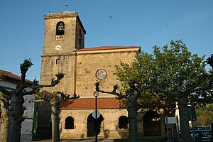
Zumaia
Municipality in Basque Country, Spain
Distance: Approx. 533 meters
Latitude and longitude: 43.29722222,-2.25694444
Zumaia ([s̻umaja], Spanish: Zumaya) is a small town in the north of Spain in the Basque Country. The town has two beaches (Itzurun and Santiago), which are of interest to geologists because they are situated among the longest set of continuous rock strata in the world. These formations are termed flysch and they date from the mid-cretaceous period to the present, a time period of over 100 million years.

Aizarnazabal
Municipality in Basque Country, Spain
Distance: Approx. 5107 meters
Latitude and longitude: 43.25583333,-2.23638889
Aizarnazabal is a town located in the province of Gipuzkoa, in the autonomous community of Basque Country, in the north of Spain. As of 2014 it had a total population of 775 inhabitants.
Getaria, Spain
Place in Basque Country, Spain
Distance: Approx. 3939 meters
Latitude and longitude: 43.30444444,-2.20361111
Getaria is a town on the Urola coast, in the province of Gipuzkoa, in the autonomous community of the Basque Country, in northern Spain. It borders Zarautz to the east and Zumaia to the west. Getaria is well-known for being the hometown of Juan Sebastián Elcano: a sailor famous for being the first to circumnavigate the world.
Selandian
Second Age of the Paleocene Epoch
Distance: Approx. 612 meters
Latitude and longitude: 43.30055556,-2.25944444
The Selandian is a stage in the Paleocene. It spans the time between 61.6 and 59.2 Ma. It is preceded by the Danian and followed by the Thanetian.

Battle of Getaria
1638 naval battle
Distance: Approx. 4205 meters
Latitude and longitude: 43.3,-2.2
The Battle of Getaria was fought on 22 August 1638 during the Franco-Spanish War (1635–59), at Getaria, in northern Spain. A French naval force commanded by Henri de Sourdis attacked and destroyed a Spanish squadron under Lope de Hoces, who survived but was killed at the Battle of the Downs in 1639. The French fleet was being used to support the siege of Fuenterrabía, a vital Spanish port.

Getariako Txakolina
Distance: Approx. 3801 meters
Latitude and longitude: 43.30138889,-2.205
Txakoli de Getaria - Getariako Txakolina is a Spanish Denominación de Origen Protegida (DOP) (Basque: Jatorri Deitura Babestua) for wines, located around the towns of Getaria and Zarautz, small fishing towns on the coast of the Bay of Biscay, in the province of Gipuzkoa, Basque Country, Spain. A small amount of grapes are also grown around the town of Aia. Txakoli is a white wine that can be naturally sparkling, and is traditionally served poured from a height into the glass.

San Anton (Getaria)
Mountain in Spain
Distance: Approx. 4202 meters
Latitude and longitude: 43.30888889,-2.20138889
San Anton (known also as Getaria's mouse because of its form), is the mountain and half-island located off the coast of Getaria, Gipuzkoa, Spain. San Anton is attached to the mainland by a breakwater. It has an abrupt slope, and is one of the most popular places of Basque Country.

Church of San Salvador (Getaria)
Historic site in Getaria, Gipuzkoa
Distance: Approx. 3968 meters
Latitude and longitude: 43.305038,-2.203357
The Church of San Salvador (Basque: San Salbador Eliza, Spanish: Iglesia de San Salvador) is a church located in Getaria, Gipuzkoa. It was declared Bien de Interés Cultural in 1895.

Basque Coast Geopark
Geopark in Basque Country
Distance: Approx. 4714 meters
Latitude and longitude: 43.298,-2.31
The Basque Coast Geopark (Basque language: Euskal Kostaldeko Geoparkea), formally the Basque Coast UNESCO Global Geopark, is an area of the Basque Country in the north of Spain which became a member of the European Geoparks Network in 2010, one of several Global Geoparks in Spain. It comprises 89 square kilometres of countryside with a 23 km long cliffed coast fronting the Bay of Biscay. Inland it comprises hilly country which reaches up to Sesiarte which is 755m above sea level.

Zarautz station
Railway station in Zarautz, Basque Country, Spain
Distance: Approx. 6775 meters
Latitude and longitude: 43.28434694,-2.17120694
Zarautz is a railway station in Zarautz, Basque Country, Spain. It is owned by Euskal Trenbide Sarea and operated by Euskotren. It lies on the Bilbao-San Sebastián line.

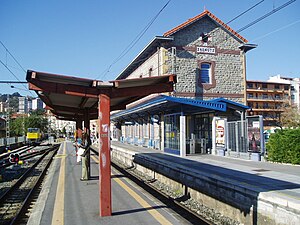
Zumaia station
Railway station in Zumaia, Basque Country, Spain
Distance: Approx. 973 meters
Latitude and longitude: 43.29156389,-2.25182611
Zumaia is a railway station in Zumaia, Basque Country, Spain. It is owned by Euskal Trenbide Sarea and operated by Euskotren. It lies on the Bilbao-San Sebastián line.
Arroa station
Railway station in Zestoa, Basque Country, Spain
Distance: Approx. 2875 meters
Latitude and longitude: 43.27841111,-2.27073056
Arroa is a railway station in Zestoa, Basque Country, Spain. It is owned by Euskal Trenbide Sarea and operated by Euskotren. It lies on the Bilbao-San Sebastián line.
Weather in this IP's area
few clouds
8 Celsius
6 Celsius
7 Celsius
9 Celsius
1022 hPa
93 %
1022 hPa
1022 hPa
10000 meters
2.07 m/s
2.39 m/s
162 degree
16 %
08:02:39
17:44:55
