Country:
Region:
City:
Latitude and Longitude:
Time Zone:
Postal Code:
IP information under different IP Channel
ip-api
Country
Region
City
ASN
Time Zone
ISP
Blacklist
Proxy
Latitude
Longitude
Postal
Route
Luminati
Country
Region
md
City
madrid
ASN
Time Zone
Europe/Madrid
ISP
Inetum Espana, S.A.
Latitude
Longitude
Postal
IPinfo
Country
Region
City
ASN
Time Zone
ISP
Blacklist
Proxy
Latitude
Longitude
Postal
Route
db-ip
Country
Region
City
ASN
Time Zone
ISP
Blacklist
Proxy
Latitude
Longitude
Postal
Route
ipdata
Country
Region
City
ASN
Time Zone
ISP
Blacklist
Proxy
Latitude
Longitude
Postal
Route
Popular places and events near this IP address

Vallecas
Neighborhood of Madrid, Spain
Distance: Approx. 812 meters
Latitude and longitude: 40.38333333,-3.61666667
Vallecas [baˈʎekas] was a municipality of Spain that disappeared as such in 1950, when its annexation to the municipality of Madrid took place. Nowadays, the territory is roughly occupied by two districts: Puente de Vallecas (population 240,917) and Villa de Vallecas (population 65,162).
Villa de Vallecas
District of Madrid in Spain
Distance: Approx. 740 meters
Latitude and longitude: 40.379597,-3.621347
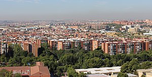
Villa de Vallecas ([ˈbiʝa ðe βaˈʝekas], "Village of Vallecas") is one of the 21 districts of the city of Madrid, Spain. It forms, with the district of Puente de Vallecas, the geographical area of Vallecas.
Church of St Peter ad Vincula, Madrid
Historic site in Madrid, Spain
Distance: Approx. 712 meters
Latitude and longitude: 40.380464,-3.620179
The Church of St Peter ad Vincula (Spanish: Iglesia de San Pedro ad Vincula) is a church located in Villa de Vallecas district in Madrid (Spain). The design of the building is attributed to the well-known architect Juan de Herrera. It was built towards the end of the sixteenth century and replaced an earlier church on the same site.
Ciudad Deportiva Rayo Vallecano
Distance: Approx. 74 meters
Latitude and longitude: 40.376,-3.613
Ciudad Deportiva Fundación Rayo Vallecano is the training ground of Rayo Vallecano. It is located in Madrid.
Sierra de Guadalupe (Madrid Metro)
Madrid Metro station
Distance: Approx. 1168 meters
Latitude and longitude: 40.3825,-3.6249
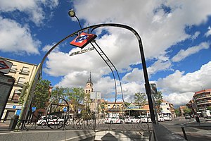
Sierra de Guadalupe [ˈsjera ðe ɣwaðaˈlupe] is a station on Line 1 of the Madrid Metro. It is located in fare Zone A. The station opened on 3 March 1999. The station is adjacent to Cercanías Madrid's Vallecas station, which is served by the C-2, C-7, and C-8 commuter rail lines.

Villa de Vallecas (Madrid Metro)
Madrid Metro station
Distance: Approx. 736 meters
Latitude and longitude: 40.3795968,-3.621302
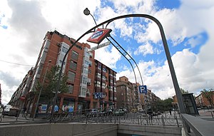
Villa de Vallecas [ˈbiʝa ðe βaˈʝekas] is a station on Line 1 of the Madrid Metro. It is located in fare Zone A. The station has been opened since 3 March 1991.

Congosto (Madrid Metro)
Madrid Metro station
Distance: Approx. 625 meters
Latitude and longitude: 40.3723846,-3.6188449
Congosto [koŋˈɡosto] is a station on Line 1 of the Madrid Metro. It is located in fare Zone A. The station opened on 3 March 1999. It is named for the Calle Congosto.
La Gavia (Madrid Metro)
Madrid Metro station
Distance: Approx. 804 meters
Latitude and longitude: 40.3692237,-3.6125821
La Gavia [la ˈɣaβja] is a station on Line 1 of the Madrid Metro. It is located in fare Zone A. The station opened on 16 May 2007. It is named for the nearby Avenida de la Gavia.

Las Suertes (Madrid Metro)
Madrid Metro station
Distance: Approx. 1896 meters
Latitude and longitude: 40.3632247,-3.5995284
Las Suertes [las ˈsweɾtes] is a station on Line 1 of the Madrid Metro. It is located in fare Zone A. The station opened on 16 May 2007. Its name comes from the nearby Avenida de las Suertes.

Faunia
Zoo and a botanical garden in Madrid
Distance: Approx. 1728 meters
Latitude and longitude: 40.3919,-3.6125
Faunia is a zoo and a botanical garden located in Madrid, Spain. It covers about fourteen square hectares and is organized into areas representing different ecosystems, such as jungle, polar regions, and African forest. It is owned by Parques Reunidos, SA. Faunia was opened on July 10, 2001, under the name Parque Biológico de Madrid.
Santa Eugenia (Madrid)
City neighborhood in Madrid, Community of Madrid, Spain
Distance: Approx. 796 meters
Latitude and longitude: 40.38333333,-3.61138889
Santa Eugenia is an administrative neighborhood (barrio) of Madrid belonging to the district of Villa de Vallecas. It has an area of 2.070637 km2 (0.799477 sq mi). As of 1 March 2020, it has a population of 24,782.
Hospital Universitario Infanta Leonor
Hospital in Community of Madrid, Spain
Distance: Approx. 1157 meters
Latitude and longitude: 40.38627,-3.61798
The Hospital Universitario Infanta Leonor is a general hospital managed under a public–private partnership model, located at the neighborhood of Santa Eugenia,in the Villa de Vallecas district in Madrid, Spain. It is part of the network of hospitals of the Servicio Madrileño de Salud (SERMAS). It is one of the healthcare institutions associated to the Complutense University of Madrid (UCM) for the purpose of clinical internship.
Weather in this IP's area
clear sky
14 Celsius
14 Celsius
13 Celsius
15 Celsius
1020 hPa
76 %
1020 hPa
946 hPa
10000 meters
3.6 m/s
100 degree
07:59:45
17:58:20


