188.191.30.86 - IP Lookup: Free IP Address Lookup, Postal Code Lookup, IP Location Lookup, IP ASN, Public IP
Country:
 Ukraine
Region:
City:
Location:
Time Zone:
Postal Code:
ISP:
ASN:
language:
User-Agent:
Proxy IP:
Blacklist:
IP information under different IP Channel
ip-api
Country
Region
City
ASN
Time Zone
ISP
Blacklist
Proxy
Latitude
Longitude
Postal
Route
db-ip
Country
Region
City
ASN
Time Zone
ISP
Blacklist
Proxy
Latitude
Longitude
Postal
Route
IPinfo
Country
Region
City
ASN
Time Zone
ISP
Blacklist
Proxy
Latitude
Longitude
Postal
Route
IP2Location
188.191.30.86Country
uaRegion
avtonomna respublika krym
City
rodnykove
Time Zone
Europe/Simferopol
ISP
Language
User-Agent
Latitude
Longitude
Postal
ipdata
Country
Region
City
ASN
Time Zone
ISP
Blacklist
Proxy
Latitude
Longitude
Postal
Route
Popular places and events near this IP address
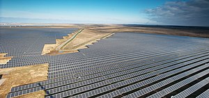
Perovo Solar Park
Photovoltaic power station in Crimea
Distance: Approx. 9712 meters
Latitude and longitude: 44.9579,33.9269
The Perovo Solar Park (Russian: СЭС «Перово») or Perove Solar Park (Ukrainian: СЕС «Перове», romanized: SES Perove) is a 100 MWp photovoltaic power station located at Klyuchi — a part of Perove, Simferopol Raion, Crimea, Ukraine. As of July 2012, it was the world's fourth-largest solar farm, and was made up of 440,000 solar panels. It is owned by Activ Solar, and the final 20 MW stage was completed on December 29, 2011.

Hvardiiske, Simferopol Raion
Urban-type settlement
Distance: Approx. 7300 meters
Latitude and longitude: 45.1,34
Hvardiiske (Crimean Tatar: Sarabuz, Russian: Гвардейское, Ukrainian: Гвардійське) is an urban-type settlement in Simferopol Raion of the Autonomous Republic of Crimea, a territory recognized by a majority of countries as part of Ukraine and incorporated by Russia as part of the Republic of Crimea since the 2014 annexation of Crimea. Population: 12,589 (2014 Census).

Molodizhne, Simferopol Raion
Urban-type settlement in Crimea
Distance: Approx. 8936 meters
Latitude and longitude: 45,34.05
Molodizhne (Crimean Tatar: Molodöjnoye, Russian: Молодёжное, Ukrainian: Молодіжне) is an urban-type settlement in Simferopol Raion of the Autonomous Republic of Crimea, a territory recognized by a majority of countries as part of Ukraine and incorporated by Russia as the Republic of Crimea. Population: 7,597 (2014 Census).
Hresivskyi
Urban-type settlement in Crimea, Disputed:
Distance: Approx. 6751 meters
Latitude and longitude: 45.00972222,34.02583333
Hresivskyi (Ukrainian: Гресівський; Crimean Tatar: Gresovskiy; Russian: Грэсовский, romanized: Gresovskiy) is an urban-type settlement located in Simferopol Municipality, Crimea. Population: 9,835 (2014 Census).

Aeroflotskyi
Urban-type settlement in Crimea
Distance: Approx. 4516 meters
Latitude and longitude: 45.02,34.00138889
Aeroflotskyi (Russian: Аэрофлотский; Ukrainian: Аерофло́тський; Crimean Tatar: Aeroflotskiy) is an urban-type settlement located in Simferopol Municipality, Crimea. It has a population of 1,768 (2014 Census).

Komsomolske, Crimea
Urban-type settlement in Crimea, Disputed:
Distance: Approx. 6482 meters
Latitude and longitude: 45.01944444,34.02944444
Komsomolske (Ukrainian: Комсомольське; Russian: Комсомольское), also known as Bakachyk-Kyiat (Ukrainian: Бакачик-Кият, Crimean Tatar: Baqaçıq Qıyat) is an urban-type settlement located in Simferopol Municipality, Crimea. It has a population of 4,447 (2014 Census).
Ahrarne
Urban-type settlement in Crimea, Disputed:
Distance: Approx. 8276 meters
Latitude and longitude: 45.01472222,34.05138889
Ahrarne (Russian: Аграрное; Ukrainian: Аграрне; Crimean Tatar: Agrarne) is an urban-type settlement located in Simferopol Municipality, Crimea. Population: 3,754 (2014 Census).

Bitumne
Village in Crimea, Disputed:
Distance: Approx. 7596 meters
Latitude and longitude: 45.01944444,34.04472222
Bitumne (Russian: Битумное; Ukrainian: Бітумне; Crimean Tatar: Qara Qıyat) is a village located in Simferopol Municipality. Population: 242 (2014 Census).

Gvardeyskoye (air base)
Military airport in Crimea
Distance: Approx. 8369 meters
Latitude and longitude: 45.11611111,33.97888889
Gvardeyskoye or Hvardiiske (Russian: Гвардейское; Ukrainian: Гвардійське) is an airbase of the Russian Aerospace Forces in Hvardiiske, Simferopol Raion, in Russian occupied Crimea, Ukraine. The history of flying here began in the 1930s when Polikarpov Po-2s were flown. The base is home to the 37th Guards Composite Aviation Regiment, which flies the Sukhoi Su-24M (ASCC: Fencer) and the Sukhoi Su-25SM/25UB (ASCC: Frogfoot under the 27th Composite Aviation Division as part of the 4th Air and Air Defence Forces Army, Southern Military District.
Weather in this IP's area
clear sky
-2 Celsius
-9 Celsius
-2 Celsius
-2 Celsius
1032 hPa
69 %
1032 hPa
1011 hPa
10000 meters
8.97 m/s
16.03 m/s
58 degree
4 %