188.173.132.195 - IP Lookup: Free IP Address Lookup, Postal Code Lookup, IP Location Lookup, IP ASN, Public IP
Country:
 Romania
Region:
City:
Location:
Time Zone:
Postal Code:
ISP:
ASN:
language:
User-Agent:
Proxy IP:
Blacklist:
IP information under different IP Channel
ip-api
Country
Region
City
ASN
Time Zone
ISP
Blacklist
Proxy
Latitude
Longitude
Postal
Route
db-ip
Country
Region
City
ASN
Time Zone
ISP
Blacklist
Proxy
Latitude
Longitude
Postal
Route
IPinfo
Country
Region
City
ASN
Time Zone
ISP
Blacklist
Proxy
Latitude
Longitude
Postal
Route
IP2Location
188.173.132.195Country
roRegion
harghita
City
miercurea-ciuc
Time Zone
Europe/Bucharest
ISP
Language
User-Agent
Latitude
Longitude
Postal
ipdata
Country
Region
City
ASN
Time Zone
ISP
Blacklist
Proxy
Latitude
Longitude
Postal
Route
Popular places and events near this IP address

Harghita County
County of Romania
Distance: Approx. 1113 meters
Latitude and longitude: 46.36,25.8
Harghita County (Romanian: Județul Harghita, Romanian pronunciation: [harˈɡita] and Hungarian: Hargita megye, pronounced [ˈhɒrɡitɒ]) is a county (județ) in the center of Romania, in eastern Transylvania, with the county seat at Miercurea Ciuc.

Miercurea Ciuc
Municipality in Harghita, Romania
Distance: Approx. 1059 meters
Latitude and longitude: 46.35944444,25.80166667
Miercurea Ciuc (Romanian: [ˈmjerkure̯a ˈtʃjuk] ; Hungarian: Csíkszereda [ˈt͡ʃiːksɛrɛdɒ] ; German: Szeklerburg) is the county seat of Harghita County, Romania. It lies in the Székely Land, a mainly Hungarian-speaking ethno-cultural region in eastern Transylvania, and is situated in the Olt River valley. The city administers three villages: Ciba (Csiba), Harghita-Băi (Hargita-fürdő), and Jigodin-Băi (Zsögöd-fürdő), including Jigodin (Csíkzsögöd).

Csík County
County of the Kingdom of Hungary
Distance: Approx. 1855 meters
Latitude and longitude: 46.36666667,25.8
Csík (Hungarian, in Romanian: Ciuc) was an administrative county (comitatus) of the Kingdom of Hungary. Its territory is now in central Romania (eastern Transylvania). The capital of the county was Csíkszereda (now Miercurea Ciuc).

Leliceni
Commune in Harghita, Romania
Distance: Approx. 3842 meters
Latitude and longitude: 46.35,25.85
Leliceni (Hungarian: Csíkszentlélek or colloquially Szentlélek, meaning "Holy Spirit", Hungarian pronunciation:[ˈtʃiːksɛntleːlɛk]) is a commune in Harghita County, Romania. It lies in the Székely Land, an ethno-cultural region in eastern Transylvania.

Lajos Vákár Ice Hall
Multipurpose hall in Romania
Distance: Approx. 887 meters
Latitude and longitude: 46.357969,25.80033
Lajos Vákár Ice Hall (Hungarian: Vákár Lajos Műjégpálya, Romanian: Patinoarul Lajos Vákár) is a multi-purpose hall in Miercurea Ciuc, Romania. The arena is frequently used for concerts, indoor sports such as ice hockey, exhibitions and shows and it was also the host stadium of the 2007 IIHF World U20 Championship. Next door to the arena is the Lajos Vákár artificial skate rink an outdoor speed skating oval constructed in 1952.

Șumuleu Ciuc
Neighborhood in Harghita County, Romania
Distance: Approx. 3730 meters
Latitude and longitude: 46.37861111,25.82527778
Șumuleu Ciuc (Hungarian: Csíksomlyó, pronounced [ˈt͡ʃiːkʃomjoː]) is a neighbourhood in the city of Miercurea Ciuc, Harghita County, Romania. Until 1959, it was a separate commune. It is the site of an annual Roman Catholic pilgrimage, when Catholics from all over Hungary, Slovakia and Romania gather there.

Pustnic
River in Harghita County, Romania
Distance: Approx. 3528 meters
Latitude and longitude: 46.3716,25.7664
The Pustnic is a left tributary of the river Olt in Romania. It flows into the Olt near Miercurea Ciuc. Its length is 15 km (9.3 mi) and its basin size is 46 km2 (18 sq mi).
Fitod
River in Harghita County, Romania
Distance: Approx. 1399 meters
Latitude and longitude: 46.3376,25.803
The Fitod is a left tributary of the river Olt in Romania. It flows into the Olt in Jigodin-Băi. The Șuta Dam is built on this river.
Beta (Olt)
River in Harghita County, Romania
Distance: Approx. 5074 meters
Latitude and longitude: 46.384,25.756
The Beta is a right tributary of the river Olt in Romania. It discharges into the Olt in Ciba, part of Miercurea Ciuc. Its length is 10 km (6.2 mi) and its basin size is 13 km2 (5.0 sq mi).

Mikó Castle
Distance: Approx. 713 meters
Latitude and longitude: 46.35611111,25.80277778
The Mikó Castle (Romanian: Castelul Mikó; Hungarian: Mikó-vár) is a fortified castle in Miercurea Ciuc (Csíkszereda), Romania. It is among the city's most important monuments, and today houses an ethnographic museum devoted to Székely heritage. Work on the castle, which is 75 m long and 70 m wide, began on 26 April 1623 and probably was completed in the 1630s.

Dacian fortress of Jigodin
Distance: Approx. 1113 meters
Latitude and longitude: 46.34,25.8
It was a Dacian fortified town.
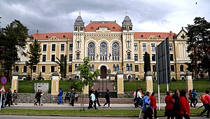
Márton Áron National College
Distance: Approx. 2030 meters
Latitude and longitude: 46.3676,25.8069
Márton Áron National College (Romanian: Colegiul Național Márton Áron; Hungarian: Márton Áron Főgimnázium) is a high school located at 72 Márton Áron Street, Miercurea Ciuc, Romania.
Weather in this IP's area
overcast clouds
-5 Celsius
-5 Celsius
-5 Celsius
-5 Celsius
1036 hPa
94 %
1036 hPa
920 hPa
6788 meters
0.75 m/s
0.93 m/s
309 degree
90 %