188.173.121.119 - IP Lookup: Free IP Address Lookup, Postal Code Lookup, IP Location Lookup, IP ASN, Public IP
Country:
Region:
City:
Location:
Time Zone:
Postal Code:
ISP:
ASN:
language:
User-Agent:
Proxy IP:
Blacklist:
IP information under different IP Channel
ip-api
Country
Region
City
ASN
Time Zone
ISP
Blacklist
Proxy
Latitude
Longitude
Postal
Route
db-ip
Country
Region
City
ASN
Time Zone
ISP
Blacklist
Proxy
Latitude
Longitude
Postal
Route
IPinfo
Country
Region
City
ASN
Time Zone
ISP
Blacklist
Proxy
Latitude
Longitude
Postal
Route
IP2Location
188.173.121.119Country
Region
dambovita
City
targoviste
Time Zone
Europe/Bucharest
ISP
Language
User-Agent
Latitude
Longitude
Postal
ipdata
Country
Region
City
ASN
Time Zone
ISP
Blacklist
Proxy
Latitude
Longitude
Postal
Route
Popular places and events near this IP address

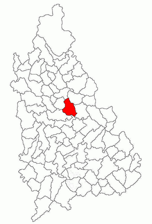
Dâmbovița County
County of Romania
Distance: Approx. 3673 meters
Latitude and longitude: 44.89,25.47
Dâmbovița County (Romanian pronunciation: [ˈdɨmbovitsa] ; also spelt Dîmbovița) is a county (județ) of Romania, in Muntenia, with the capital city at Târgoviște, the most important economic, political, administrative and cultural center of the county. It is a traditional administrative unit, first attested in 1512.

Târgoviște
Municipality in Dâmbovița, Romania
Distance: Approx. 360 meters
Latitude and longitude: 44.92444444,25.45722222
Târgoviște (Romanian pronunciation: [tɨrˈɡoviʃte], alternatively spelled Tîrgoviște) is a city and county seat in Dâmbovița County, Romania. It is situated 80 kilometres (50 miles) north-west of Bucharest, on the right bank of the Ialomița River. Târgoviște was one of the most important cities in the history of Wallachia, as it was its capital from 1418 to 1659.

Chindia Tower
Tower in Târgoviște, Romania
Distance: Approx. 1244 meters
Latitude and longitude: 44.93243611,25.458175
The Chindia Tower (Romanian: Turnul Chindiei) is a tower in the Curtea Domnească monuments ensemble in Târgoviște, Romania, built in the 15th century. The tower was begun during the second reign of Prince Vlad III the Impaler over Wallachia and took its final form during the 19th century. It initially had a military purpose, but during its history, it has been used as a guard point, a fire spotter, and for storing and protecting the state treasury.
Dealu Monastery
Monastery in Dâmbovița County, Romania
Distance: Approx. 4594 meters
Latitude and longitude: 44.958351,25.481675
Dealu Monastery is a 15th-century monastery in Dâmbovița County, Romania, located 6 km north of Târgoviște. The church of the monastery is dedicated to Saint Nicholas.
Slănic de Răzvad
River in Dâmbovița County, Romania
Distance: Approx. 6146 meters
Latitude and longitude: 44.9191,25.5336
The Slănic de Răzvad (also: Slănicul de Sus or Slănic) is a left tributary of the river Ialomița in Romania. It flows into the Ialomița near Nisipurile. Its length is 22 km (14 mi) and its basin size is 47 km2 (18 sq mi).

Valahia University of Târgoviște
Distance: Approx. 315 meters
Latitude and longitude: 44.923934,25.457484
The Valahia University of Târgovişte is a university in Târgoviște, Dâmbovița County, Romania.

Ulmi, Dâmbovița
Commune in Dâmbovița, Romania
Distance: Approx. 2241 meters
Latitude and longitude: 44.91666667,25.48333333
Ulmi is a commune in Dâmbovița County, Muntenia, Romania. It is composed of eight villages: Colanu, Dimoiu, Dumbrava, Matraca, Nisipurile, Udrești, Ulmi, and Viișoara.

Răzvad
Commune in Dâmbovița, Romania
Distance: Approx. 6261 meters
Latitude and longitude: 44.93333333,25.53333333
Răzvad is a commune in Dâmbovița County, Muntenia, Romania with a population of 8,729 people as of 2021. It is composed of three villages: Gorgota, Răzvad, and Valea Voievozilor. The commune is located in the central part of Dâmbovița County, east of the county seat, Târgoviște, on the left bank of the Ialomița River.

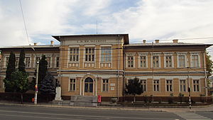
Ienăchiță Văcărescu National College
Romanian high school
Distance: Approx. 1889 meters
Latitude and longitude: 44.9275,25.43333333
The Ienăchiță Văcărescu National College (Romanian: Colegiul Național Ienăchiță Văcărescu) is a high school located at 235 Calea Domnească, Târgoviște, Dâmbovița County, Romania. It was established at the end of the 19th century and is the oldest high school in the city. Previously a theoretical high school, it was declared a national college in 1999.

Târgoviște Army Arsenal
Distance: Approx. 573 meters
Latitude and longitude: 44.92436111,25.46163889
Initially established as the Army Foundry (Romanian: Fonderia Armatei) through a decree issued by Domnitor Alexandru Ioan Cuza in 1864, the Târgoviște Army Arsenal (Arsenalul Armatei din Târgoviște) became an arsenal of the Romanian Army in 1872, being renamed as such in 1876. Between 1876 and 1935, it mainly functioned as a storage arsenal. During the Second World War, various weapons and equipment were repaired here.

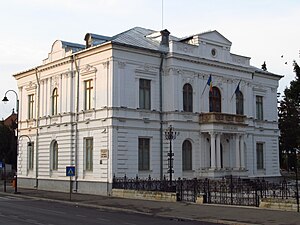
Târgoviște Art Museum
Art museum in Târgoviște, Romania
Distance: Approx. 1102 meters
Latitude and longitude: 44.930802,25.460069
The Târgoviște Art Museum (Romanian: Muzeul de Artă din Târgoviște) is situated on Calea Domnească Târgoviște, Romaniain in close proximity to the Museum of History and the Princely Court.

Târgoviște Princely Court
Monument in Târgoviște, Romania
Distance: Approx. 1244 meters
Latitude and longitude: 44.93243611,25.458175
Târgoviște Princely Court (Romanian: Curtea Domnească of Târgoviște) represents a complex of medieval buildings and fortifications that served as the residence of various rulers of Wallachia and, at the same time, played a relatively important role in the country's defensive system.
Weather in this IP's area
clear sky
4 Celsius
4 Celsius
4 Celsius
4 Celsius
1029 hPa
74 %
1029 hPa
994 hPa
10000 meters
0.75 m/s
0.73 m/s
64 degree
