Country:
 Russian Federation
Region:
City:
Latitude and Longitude:
Time Zone:
Postal Code:
IP information under different IP Channel
ip-api
Country
Region
City
ASN
Time Zone
ISP
Blacklist
Proxy
Latitude
Longitude
Postal
Route
IPinfo
Country
Region
City
ASN
Time Zone
ISP
Blacklist
Proxy
Latitude
Longitude
Postal
Route
MaxMind
Country
Region
City
ASN
Time Zone
ISP
Blacklist
Proxy
Latitude
Longitude
Postal
Route
Luminati
Country
RUASN
Time Zone
Europe/Moscow
ISP
Joint Stock Company TransTeleCom
Latitude
Longitude
Postal
db-ip
Country
Region
City
ASN
Time Zone
ISP
Blacklist
Proxy
Latitude
Longitude
Postal
Route
ipdata
Country
Region
City
ASN
Time Zone
ISP
Blacklist
Proxy
Latitude
Longitude
Postal
Route
Popular places and events near this IP address
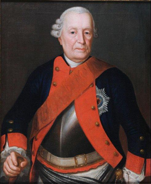
Hans von Lehwaldt
Prussian Generalfeldmarschall (1685–1768)
Distance: Approx. 1868 meters
Latitude and longitude: 54.71583333,20.42472222
Hans von Lehwald(t) (24 June 1685 – 16 November 1768), also known as Johann von Lehwald(t), was a Prussian Generalfeldmarschall. He joined the military in 1700 and participated in all Prussian field operations from the War of Spanish Succession through the Seven Years' War. He served with particular distinction in Frederick the Great's war with the Austrians in the Silesia and Seven Years' War.

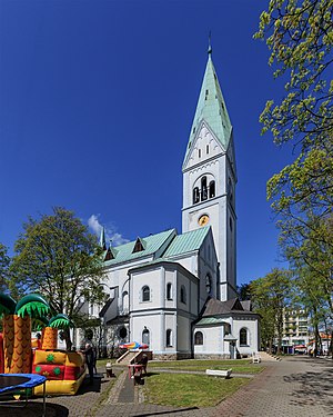
Juditten Church
Church in Russia
Distance: Approx. 1868 meters
Latitude and longitude: 54.71583333,20.42472222
Juditten Church (German: Juditter Kirche; Russian: Юдиттен-кирха) is a Russian Orthodox church in the Mendeleyevo district of Kaliningrad, Russia. originally built as a Roman Catholic church, it later become a Prussian Union (Protestant) church. Juditten was the name of the Mendeleyevo district when it was a quarter of Königsberg, East Prussia, Germany.
Hufen
Distance: Approx. 1831 meters
Latitude and longitude: 54.7176,20.4778
Hufen was a broad region along northwestern Königsberg, Germany, which developed into the quarters of Ratshof, Amalienau, Mittelhufen, and Vorderhufen. The territory is now part of the Tsentralny District of Kaliningrad, Russia.
Kosse (Königsberg)
Distance: Approx. 1782 meters
Latitude and longitude: 54.7075,20.47944444
Kosse or Cosse was a quarter of western Königsberg, Germany. Its territory is now part of the Tsentralny District of Kaliningrad, Russia. Kosse was originally a fishing village under the control of Altstadt on the northern shore of the lower Pregel.

Amalienau
Distance: Approx. 1185 meters
Latitude and longitude: 54.71805556,20.465
Amalienau was a suburban quarter of western Königsberg, Germany. Its territory is now part of the Tsentralny District of Kaliningrad, Russia.

Kaliningrad Central Park
Park in Kaliningrad, Russia
Distance: Approx. 1825 meters
Latitude and longitude: 54.7175,20.47777778
Kaliningrad Central Park (Russian: Центральный парк Калининграда) is a park in Kaliningrad, Russia. It was known as Luisenwahl while part of Königsberg, Germany, until 1945.
Kaliningrad Puppet Theatre
Distance: Approx. 1823 meters
Latitude and longitude: 54.71944444,20.47583333
The Kaliningrad Puppet Theatre (Russian: Калининградский кукольный театр) is a puppet theatre in Kaliningrad, Russia. The building was originally the Königin-Luise-Gedächtniskirche (Queen Louise Memorial Church), popularly known as the Luisenkirche, a Protestant church in Königsberg, Germany.

Ratshof
Distance: Approx. 1043 meters
Latitude and longitude: 54.71972222,20.45388889
Ratshof or Rathshof was a suburban quarter of western Königsberg, Germany. Its territory is now part of the Tsentralny District of Kaliningrad, Russia.

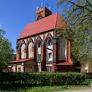
Ratshof Church
Distance: Approx. 187 meters
Latitude and longitude: 54.71194444,20.45333333
Ratshof Church (German: Ratshöfer Kirche) or Christuskirche (Christ Church) was a Protestant church in western Königsberg, Germany. It was the final church constructed in the city before it became Russian Kaliningrad. The church in Ratshof was designed in 1932 by architect Kurt Frick of the Kunstakademie Königsberg.
Lawsken
Distance: Approx. 690 meters
Latitude and longitude: 54.71222222,20.44194444
Lawsken was a suburban village and then quarter of Königsberg, Germany. Its territory is now part of the Tsentralny District of Kaliningrad, Russia.
St. Adalbert's Church, Königsberg
Distance: Approx. 984 meters
Latitude and longitude: 54.71472222,20.46555556
St. Adalbert's Church (German: Adalberts-Kirche; Russian: Кирха Святого Адальберта) was a Roman Catholic church in western Königsberg, Germany. It is now used by the Russian Orthodox Church.

Kaliningrad
Russian Baltic city between Poland and Lithuania
Distance: Approx. 1128 meters
Latitude and longitude: 54.70027778,20.45305556
Kaliningrad, known as Königsberg until 1946, is the largest city and administrative centre of Kaliningrad Oblast, a Russian exclave between Lithuania and Poland. The city sits about 663 kilometres (412 mi) west of the bulk of Russia. The city is situated on the Pregolya River, at the head of the Vistula Lagoon on the Baltic Sea, and is the only ice-free Russian port on the Baltic Sea.
Weather in this IP's area
overcast clouds
11 Celsius
10 Celsius
8 Celsius
11 Celsius
1011 hPa
78 %
1011 hPa
1011 hPa
10000 meters
2.46 m/s
4.59 m/s
156 degree
98 %
06:53:59
17:57:03