Country:
Region:
City:
Latitude and Longitude:
Time Zone:
Postal Code:
IP information under different IP Channel
ip-api
Country
Region
City
ASN
Time Zone
ISP
Blacklist
Proxy
Latitude
Longitude
Postal
Route
Luminati
Country
Region
wls
City
cardiff
ASN
Time Zone
Europe/London
ISP
Spectrum Internet Ltd
Latitude
Longitude
Postal
IPinfo
Country
Region
City
ASN
Time Zone
ISP
Blacklist
Proxy
Latitude
Longitude
Postal
Route
db-ip
Country
Region
City
ASN
Time Zone
ISP
Blacklist
Proxy
Latitude
Longitude
Postal
Route
ipdata
Country
Region
City
ASN
Time Zone
ISP
Blacklist
Proxy
Latitude
Longitude
Postal
Route
Popular places and events near this IP address

Splott
Area of Cardiff, Wales
Distance: Approx. 351 meters
Latitude and longitude: 51.48357,-3.15349
Splott (Welsh: Y Sblot) is a district and community in the south of the city of Cardiff, capital of Wales, just east of the city centre. It was built up in the late 19th century on the land of two farms of the same name: Upper Splott and Lower Splott Farms. Splott is characterised by its once vast steelworks and rows of tightly knit terraced houses.
Adamsdown
Area and community in Cardiff, Wales
Distance: Approx. 336 meters
Latitude and longitude: 51.48531,-3.15929
Adamsdown (Welsh: Waunadda or Y Sblot Uchaf) is an inner city area and community in the south of Cardiff, the capital city of Wales. Adamsdown is generally located between Newport Road, to the north and the mainline railway to the south. The area includes Cardiff Prison, Cardiff Magistrates' Court, Cardiff Royal Infirmary, a University of South Wales campus, and many streets of residential housing.
Cardiff East (1918–1950 UK Parliament constituency)
Parliamentary constituency in the United Kingdom, 1918–1950
Distance: Approx. 496 meters
Latitude and longitude: 51.491,-3.156
Cardiff East was a parliamentary constituency in Cardiff which returned one Member of Parliament to the House of Commons of the Parliament of the United Kingdom from 1918 until it was abolished for the 1950 general election.
Cardiff Royal Infirmary
Hospital in Wales
Distance: Approx. 491 meters
Latitude and longitude: 51.4847,-3.1613
Cardiff Royal Infirmary (Welsh: Ysbyty Brenhinol Caerdydd) (also known as the CRI or YBC) is a hospital in central Cardiff, Wales. It is managed by the Cardiff and Vale University Health Board.

Noah's Ark Children's Hospital for Wales
Hospital in Cardiff, Wales
Distance: Approx. 523 meters
Latitude and longitude: 51.485,-3.162
The Noah's Ark Children's Hospital for Wales (Welsh: Ysbyty Arch Noa Plant Cymru) is a children's hospital in Cardiff, Wales. It is situated on the site of the University Hospital of Wales in the Heath area of the city and is managed by the Cardiff and Vale University Health Board.
Roath Library
Public library in Cardiff, Wales
Distance: Approx. 349 meters
Latitude and longitude: 51.487,-3.1599
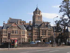
Roath Library is a Grade II listed building on Newport Road, Cardiff, on the border of the Roath and Adamsdown districts. In 2014 the library closed for repairs, and in 2015 it was decided to close the library permanently. The Roath Branch Library was designed by architects Teather & Wilson and built between 1900 and 1901 on a triangular site bounded by Newport Road, Four Elms Road and Clifton Street.

St German's Church
Church in Cardiff, Wales
Distance: Approx. 395 meters
Latitude and longitude: 51.4845,-3.1595
St German's Church (Welsh: Eglwys Sant Garmon) is a nineteenth-century Church in Wales parish church in Adamsdown, Cardiff, Wales dedicated to St Germanus of Auxerre, (the Garmon Sant of Welsh tradition). The building, located on the corner of Star Street and Metal Street, is a Grade I Listed building.

Roath railway station
Former railway station in Wales
Distance: Approx. 217 meters
Latitude and longitude: 51.4848,-3.1537
Roath railway station was a short-lived railway station in Cardiff. It opened in 1899 and closed in 1917. The station was on the South Wales Main Line.

Royal Oak, Cardiff
Pub in Cardiff, Wales
Distance: Approx. 571 meters
Latitude and longitude: 51.4903,-3.1492
The Royal Oak is a Grade II listed public house on Newport Road in the Adamsdown/Roath area of Cardiff, Wales.

Adamsdown Primary School
School in Cardiff, UK
Distance: Approx. 450 meters
Latitude and longitude: 51.483765,-3.15953
Adamsdown Primary School is a school in Adamsdown, Cardiff serving children from the ages of 3 to 11. Its motto is: Caring Sharing Learning Together. In 2009, pupils from Adamsdown Primary School recorded a song, Adamsdown Song, with local songwriter Jon Blake.

St Saviour's Church, Splott
Church in Cardiff, Wales
Distance: Approx. 395 meters
Latitude and longitude: 51.4838,-3.1514
St Saviour's Church is a Church in Wales church in Splott, Cardiff, South Wales.

Trinity Methodist Church, Cardiff
Former church in Cardiff, Wales
Distance: Approx. 377 meters
Latitude and longitude: 51.48648,-3.16034
Trinity Methodist Church, now the Trinity Centre, is a Grade II listed former Methodist church in Adamsdown, Cardiff, Wales.
Weather in this IP's area
overcast clouds
11 Celsius
11 Celsius
11 Celsius
13 Celsius
1022 hPa
93 %
1022 hPa
1021 hPa
7000 meters
2.06 m/s
100 degree
100 %
07:13:41
16:38:45


