Country:
Region:
City:
Latitude and Longitude:
Time Zone:
Postal Code:
IP information under different IP Channel
ip-api
Country
Region
City
ASN
Time Zone
ISP
Blacklist
Proxy
Latitude
Longitude
Postal
Route
Luminati
Country
ASN
Time Zone
Asia/Tehran
ISP
Tose'h Fanavari Ertebabat Pasargad Arian Co. PJS
Latitude
Longitude
Postal
IPinfo
Country
Region
City
ASN
Time Zone
ISP
Blacklist
Proxy
Latitude
Longitude
Postal
Route
db-ip
Country
Region
City
ASN
Time Zone
ISP
Blacklist
Proxy
Latitude
Longitude
Postal
Route
ipdata
Country
Region
City
ASN
Time Zone
ISP
Blacklist
Proxy
Latitude
Longitude
Postal
Route
Popular places and events near this IP address

Firooz Bahram High School
High school in Tehran Iran
Distance: Approx. 700 meters
Latitude and longitude: 35.69539,51.41385
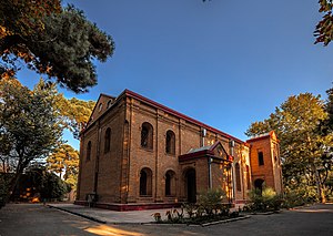
Firooz Bahram High School (دبیرستان فیروز بهرام) is one of Tehran's oldest high schools still in operation.

Greater Tehran
Metropolitan area in Iran
Distance: Approx. 237 meters
Latitude and longitude: 35.69611111,51.42305556
Greater Tehran Metropolitan Area is the urban agglomeration around Tehran that covers the central part of the Tehran Province and eastern part of the Alborz Province, that covers the contiguous cities of Tehran, Ray, Shemirānāt, and other areas. As of 2012, Greater Tehran had a population of close to 14 million residents. The 2016 census had the population at 13.3 million in Tehran Province (only 200 thousands of them outside Tehran and the suburban counties) and 2.2 million in Karaj and Fardis combined.

Baharestan (district)
District in Tehran, Iran
Distance: Approx. 439 meters
Latitude and longitude: 35.69166667,51.425
Baharestan (Persian: بهارستان) is a locality east of the central part of Tehran in Iran. The historical Baharestan building is located in this neighborhood. Kendriya Vidyalaya Tehran, the Embassy of India School, is in Baharestan.

Saadi Metro Station
Station of the Tehran Metro
Distance: Approx. 328 meters
Latitude and longitude: 35.69305556,51.42472222
Saadi Metro Station is a station in Tehran Metro Line 1. It is located in the junction of Saadi Street and Jomhuri-ye Eslami Street. It is between Imam Khomeini Metro Station and Darvaze Dolat Metro Station.
Embassy of the United Kingdom, Tehran
Diplomatic mission of UK in Iran
Distance: Approx. 358 meters
Latitude and longitude: 35.69652778,51.41852778
The Embassy of the United Kingdom in Tehran is the United Kingdom's diplomatic mission to the Islamic Republic of Iran. It is located at 172 Ferdowsi Avenue in Tehran. Following the 2011 attack on the Embassy and the expulsion of the British ambassador by Iran, Britain reduced its diplomatic relations with Iran to "the lowest possible level" and closed its embassy.
Timeline of Tehran
Distance: Approx. 237 meters
Latitude and longitude: 35.69611111,51.42305556
The following is a timeline of the history of the city of Tehran, Iran.
Islamic Republic of Iran Weightlifting Federation
Distance: Approx. 237 meters
Latitude and longitude: 35.69611111,51.42305556
Iran Weightlifting Federation (Persian: فدراسیون وزنه برداری جمهوری اسلامی ایران, IRIWF) is the governing body for weightlifting in Iran.

Abgineh Museum of Tehran
Museum in Tehran, Iran
Distance: Approx. 591 meters
Latitude and longitude: 35.69345,51.41507
The Glassware and Ceramic Museum of Iran (Persian: موزهٔ آبگینه و سفالینه ایران, Muze-ye Abgineh va Sofalineh-ye Irān) or simply Abgineh Museum (Persian: موزهٔ آبگینه, Muze-ye Abgineh) is located at 30 Tir Street (formerly known as Ghavam Al Saltaneh Street), in Tehran, Iran. It was private residence of longtime Prime Minister Ahmad Qavam from 1921 until 1951. The complex was also Embassy of Egypt for seven years.

Plasco Building
Building in Tehran, Iran
Distance: Approx. 70 meters
Latitude and longitude: 35.69472222,51.42083333
The Plasco Building (Persian: ساختمان پلاسکو, romanized: Sâxtmâne Plâskô) is a 20-story high-rise (5 floors below and 15 floors above ground) landmark building in Tehran, the capital city of Iran. It was built on the site of an earlier Plasco building, which at the time of its construction was the tallest building in Iran and was considered an iconic part of the Tehran skyline. The earlier building caught on fire and collapsed on 19 January 2017; construction on the new building began in 2018 and was completed in 2021.

Holy Mother of God Church, Tehran
Armenian Apostolic church in Tehran, Iran
Distance: Approx. 627 meters
Latitude and longitude: 35.69576547,51.4147684
Surp Asdvadzadzin Church, Holy Mother of God Church, or Saint Mary Church (Armenian: Սուրբ Աստվածածին եկեղեցի, Persian: کلیسای مریم مقدس), is an Armenian Apostolic church in Tehran, Iran completed in 1945. From 1945 to 1970 the church was the official office and the residence of the Armenians' archbishop, which was then transferred to Saint Sarkis Cathedral, Tehran.

Saint Peter Church, Tehran
Iranian national heritage site
Distance: Approx. 663 meters
Latitude and longitude: 35.69167017,51.41497761
Saint Peter Evangelical Church of Tehran, (Persian: کلیسای انجیلی پطرس), is a Protestant church in Tehran, Iran.

Argo Factory
Nonprofit Art museum in Tehran
Distance: Approx. 531 meters
Latitude and longitude: 35.69916667,51.42152778
Argo Factory (Persian: کارخانه آرگو), is a contemporary art museum and cultural centre housed in a former brewery in Tehran, Iran. Argo Factory is part of the Pejman Foundation’s sites.
Weather in this IP's area
few clouds
16 Celsius
14 Celsius
15 Celsius
17 Celsius
1025 hPa
29 %
1025 hPa
893 hPa
7000 meters
3.09 m/s
190 degree
20 %
06:35:23
17:01:13
