Country:
 Iran
IranRegion:
City:
Latitude and Longitude:
Time Zone:
Postal Code:
IP information under different IP Channel
ip-api
Country
Region
City
ASN
Time Zone
ISP
Blacklist
Proxy
Latitude
Longitude
Postal
Route
IPinfo
Country
Region
City
ASN
Time Zone
ISP
Blacklist
Proxy
Latitude
Longitude
Postal
Route
MaxMind
Country
Region
City
ASN
Time Zone
ISP
Blacklist
Proxy
Latitude
Longitude
Postal
Route
Luminati
Country
IRASN
Time Zone
Asia/Tehran
ISP
Tose'h Fanavari Ertebabat Pasargad Arian Co. PJS
Latitude
Longitude
Postal
db-ip
Country
Region
City
ASN
Time Zone
ISP
Blacklist
Proxy
Latitude
Longitude
Postal
Route
ipdata
Country
Region
City
ASN
Time Zone
ISP
Blacklist
Proxy
Latitude
Longitude
Postal
Route
Popular places and events near this IP address

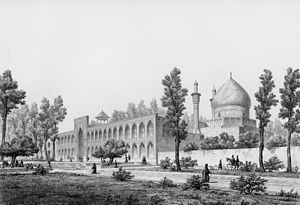
Chehel Sotoun
Pavilion in Isfahan, Iran
Distance: Approx. 708 meters
Latitude and longitude: 32.6575,51.67222222
Chehel Sotoun (Persian: چهلستون, lit. 'Forty Columns') is a Persian pavilion in the middle of a park at the far end of a long pool, in Isfahan, Iran, built by Shah Abbas II to be used for his entertainment and receptions. In this palace, Shah Abbas II and his successors would receive dignitaries and ambassadors, either on the terrace or in one of the stately reception halls. The name, meaning "Forty Columns" in Persian, was inspired by the twenty slender wooden columns supporting the entrance pavilion, which, when reflected in the waters of the fountain, is said to appear to be forty.
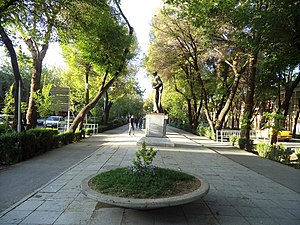
Chaharbagh, Isfahan
Distance: Approx. 262 meters
Latitude and longitude: 32.65305556,51.66861111
Chahar Bagh Boulevard (Persian: چهارباغ, translation: Four Gardens) is a historical avenue in Isfahan constructed in the Safavid era of Iran. This historic street is very similar to the Champs-Élysées in Paris, which some visitors called the Champs-Élysées of Isfahan. The avenue, historically, is the most famous in all of Persia.
Chaharbagh School
Distance: Approx. 421 meters
Latitude and longitude: 32.65129,51.66925
Chahār Bāgh School or the Chahār Bāgh Madrasa (Persian: مدرسه چهارباغ, romanized: Madreseye Chahār Bāgh, lit. 'School of the Four Gardens'), also known as Madrasa Madar-i Shah, is a 17-18th century cultural complex in Isfahan, Iran. The compound was built during the time of Soltan Hossein, a Safavid king, to serve as a theological and clerical school to train those who were interested in such sciences.
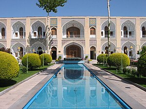
Abbasi Hotel
Distance: Approx. 510 meters
Latitude and longitude: 32.65138889,51.67055556
The Abbasi Hotel (Persian: هتل عباسی, formerly known as the "Shah Abbas Hotel", Persian: هتل شاه عباس) is a hotel located in Isfahan, Iran. The whole complex was built at the time of king Sultan Husayn of Safavid to provide lodging for travelers. Upon the suggestion of French André Godard (1881–1965), an archaeologist, architect, and historian of French and Middle Eastern Art., the Cultural Heritage Organization of Isfahan and insurance company by Civil Engineer A.Mohit decided to proceed with the renovation of the caravansary.
Enqelab Square (Isfahan)
Distance: Approx. 837 meters
Latitude and longitude: 32.64653,51.66778
Enqelab Square is a square in downtown Esfahan, Iran.
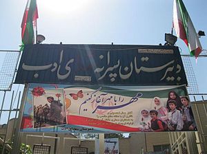
Adab High School
Public school in Iran
Distance: Approx. 750 meters
Latitude and longitude: 32.6524166,51.6738053
Adab High School in Isfahan, Iran, was established in the early 19th century by British Anglican missionaries as an all-boys school. It was later converted to a secular school and college under the direction of Isa Sadiq (a man of letters and Minister of Education) and under the administration of Sayyid Yahya DowlatAbadi. Adab High School was the only all-boys high school in Isfahan with its own swimming pool and soccer field.

Rahim Khan Mosque
Mosque in Isfahan, Iran
Distance: Approx. 660 meters
Latitude and longitude: 32.659167,51.662778
Rahim Khan Mosque (Persian: مسجد رحیم خان) is a historical mosque in Isfahan, Iran. It was built in the late 19th century. This mosque has an unusual combination of styles in architectural decorations.

Museum of Decorative Arts, Isfahan
Distance: Approx. 886 meters
Latitude and longitude: 32.658,51.6741
The museum of decorative arts in Isfahan was founded in 1995. More than 3000 artworks from the Safavid and Qajar era are kept in the museum. The building of the museum belongs to the era of Abbas I. The building was constructed during the era of Abbas I as a part of Charbagh Palace.

Natural History Museum of Isfahan
Distance: Approx. 886 meters
Latitude and longitude: 32.658,51.6741
The Natural History Museum of Isfahan, Iran, is located in a building that dates from the 15th century Timurid era. The building includes large halls and a veranda which are decorated by muqarnas and stucco. This building became a museum in 1988.
Armenian Catholic Eparchy of Isfahan
Eastern Catholic eparchy in Iran
Distance: Approx. 439 meters
Latitude and longitude: 32.65,51.6667
The Armenian Catholic Eparchy of Isfahan (or Ispahan or Esfahan) is a suffragan eparchy (Eastern Catholic diocese), covering all of Iran, in the ecclesiastical province 'of Cilicia' of the Armenian Catholic Patriarch, the head of the Armenian Catholic Church (Armenian Rite in the Armenian language). Its cathedral episcopal see is in Isfahan, Iran.
Church of St. Luke, Isfahan
Iranian national heritage site
Distance: Approx. 562 meters
Latitude and longitude: 32.64912715,51.66404754
Church of St. Luke, is an Anglican church in Isfahan, Iran. It is located in Abbasabad neighbourhood of Isfahan, next to Isa Bin Maryam Hospital.
Jahan-Nama Tower
Business
Distance: Approx. 499 meters
Latitude and longitude: 32.65785833,51.66850833
The Jahan-Nama Tower (Translit World view tower Persian:برج جهان نما) is a building built by Municipality of Isfahan in Imam Hosein Square, Isfahan. Some floors were destroyed because of ruining historic view(visual conflict) from Naghshe Jahan Square. It was first built in 1996 by demolishing historic caravansarai "Tahdid" (an Iranian Registered National Heritage).
Weather in this IP's area
clear sky
24 Celsius
23 Celsius
24 Celsius
24 Celsius
1010 hPa
20 %
1010 hPa
847 hPa
10000 meters
1.76 m/s
2.54 m/s
156 degree
05:50:18
18:03:14