Country:
 Turkey
Region:
City:
Latitude and Longitude:
Time Zone:
Postal Code:
IP information under different IP Channel
ip-api
Country
Region
City
ASN
Time Zone
ISP
Blacklist
Proxy
Latitude
Longitude
Postal
Route
IPinfo
Country
Region
City
ASN
Time Zone
ISP
Blacklist
Proxy
Latitude
Longitude
Postal
Route
MaxMind
Country
Region
City
ASN
Time Zone
ISP
Blacklist
Proxy
Latitude
Longitude
Postal
Route
Luminati
Country
TRASN
Time Zone
Europe/Istanbul
ISP
Ict Telekomunikasyon Sanayi Ticaret A.s.
Latitude
Longitude
Postal
db-ip
Country
Region
City
ASN
Time Zone
ISP
Blacklist
Proxy
Latitude
Longitude
Postal
Route
ipdata
Country
Region
City
ASN
Time Zone
ISP
Blacklist
Proxy
Latitude
Longitude
Postal
Route
Popular places and events near this IP address

Selçuklu
District and municipality in Konya, Turkey
Distance: Approx. 761 meters
Latitude and longitude: 37.88138889,32.49222222
Selçuklu is a municipality and district of Konya Province, Turkey. Its area is 1,931 km2, and its population is 690,667 (2022). Selçuklu is one of the central districts of Konya, along with the districts of Karatay and Meram.

Alâeddin Mosque
12th-century Seljuk-era mosque in Konya, Turkey
Distance: Approx. 239 meters
Latitude and longitude: 37.872655,32.492046
The Alâeddin Mosque (Turkish: Alâeddin Camii) is the principal monument on Alaaddin Hill (Alaadin Tepesi) in the centre of Konya, Turkey. Part of the hilltop citadel complex that contained the Seljuk Palace, it served as the main prayer hall for the Seljuk Sultans of Rum and its courtyard contains the burial places of several of the sultans. It was constructed in stages between the mid-12th and mid-13th centuries.
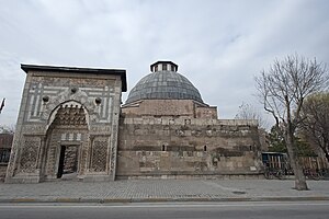
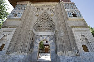
Karatay Madrasa
Madrasa in Konya, Turkey
Distance: Approx. 40 meters
Latitude and longitude: 37.87472222,32.49277778
Karatay Madrasa (Turkish: Karatay Medresesi) is a madrasa (a school with a frequently but not absolutely religious focus) in Konya, Turkey located at the foot of the citadel hill, across from the ruins of the Seljuk palace and in view of the Alâeddin Mosque. Since 1954, the building has served as a museum displaying a collection of historic tile art, particularly from the Seljuk period. The madrasa and the Karatay Han, a caravanserai completed in the 1240s, are the largest extant monuments in Konya and its immediate regions.
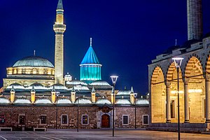
Mevlâna Museum
Tomb and memorial to the poet Rumi
Distance: Approx. 1108 meters
Latitude and longitude: 37.87055556,32.50472222
The Mevlâna Museum (Turkish: Mevlânâ Müzesi), in Konya, Turkey, started life as the dervish lodge (Tekke) of the Mevlevi order, better known as the whirling dervishes. It houses the mausoleum of Jalal ad-Din Muhammad Rumi (Turkish: Celaleddin-i Rumi), a Persian Sufi mystic.
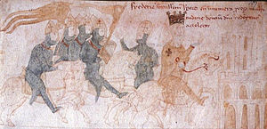
Battle of Iconium (1190)
Battle of the Third Crusade
Distance: Approx. 1237 meters
Latitude and longitude: 37.8667,32.4833
The Battle of Iconium (sometimes referred as the Battle of Konya) took place on May 18, 1190, during the Third Crusade, in the expedition of Frederick Barbarossa to the Holy Land. As a result, Iconium, the capital city of the Sultanate of Rûm under Kilij Arslan II, fell to the Imperial forces.

Aziziye Mosque, Konya
Mosque in Konya, Turkey
Distance: Approx. 844 meters
Latitude and longitude: 37.86994444,32.50077778
The Aziziye Mosque (Turkish: Aziziye Camii) is an Ottoman mosque in Konya, Turkey. It is well known for the columned balcony of its minaret, an architectural feature rarely seen in Turkish mosques.

Selimiye Mosque, Konya
Mosque in Konya, Turkey
Distance: Approx. 1069 meters
Latitude and longitude: 37.87044,32.50416
Selimiye Mosque (Selim II Mosque, Turkish: Selimiye Camisi) is a 16th-century Ottoman mosque in Konya, Turkey.
Konya Archaeological Museum
Distance: Approx. 758 meters
Latitude and longitude: 37.8678,32.4937
Konya Archaeological Museum is a state archaeological museum in Konya, Turkey. Established in 1901, it had been relocated twice before moving to its present location in 1962. One of the most prominent displays in the museum is of sarcophagi and other antiquities from the ancient city of Çatalhöyük.
Konya Ethnography Museum
Ethnographic museum in Konya, Turkey
Distance: Approx. 897 meters
Latitude and longitude: 37.86666667,32.49138889
Konya Ethnography Museum (Turkish: Konya Etnografya Müzesi) is an ethnographic museum devoted to the people, cultures and lifestyle in and around Konya, Turkey. The museum is on Sahip Ata Street. It is a two-story building with a basement.
Sahip Ata Museum
Museum in Konya, Turkey
Distance: Approx. 798 meters
Latitude and longitude: 37.8675,32.49444444
Sahip Ata Museum is an ethnography museum in Konya, Turkey. It is under the supervision of Directorate General of Foundations.

Iplikçi Mosque
13th-century Seljuk-era mosque in Konya, Turkey
Distance: Approx. 424 meters
Latitude and longitude: 37.87194444,32.49666667
The Iplikçi Mosque (Turkish: Iplikçi Camii), also known as Ebülfazl Mosque, is a 13th-century Seljuk-era Islamic Friday mosque built in 1201-2 AD (598 AH) in the city of Konya, Turkey, to the east of Alaeddin Hill (Konya's citadel).
Sahib Ata Complex
Distance: Approx. 793 meters
Latitude and longitude: 37.8675259,32.4942149
The Sahib Ata Complex (Turkish: Sâhib Atâ Külliyesi) is a historic funerary and religious complex located in Konya, Turkey. It was built between 1258 and 1285 by Sâhib Ata, the Persian vizier of the Sultanate of Rum. This religious complex consists of a mosque, mausoleum, khanqah and a hammam.
Weather in this IP's area
few clouds
9 Celsius
6 Celsius
9 Celsius
9 Celsius
1021 hPa
49 %
1021 hPa
904 hPa
10000 meters
5.14 m/s
20 degree
20 %
07:01:21
18:08:35