188.124.23.63 - IP Lookup: Free IP Address Lookup, Postal Code Lookup, IP Location Lookup, IP ASN, Public IP
Country:
Region:
City:
Location:
Time Zone:
Postal Code:
ISP:
ASN:
language:
User-Agent:
Proxy IP:
Blacklist:
IP information under different IP Channel
ip-api
Country
Region
City
ASN
Time Zone
ISP
Blacklist
Proxy
Latitude
Longitude
Postal
Route
db-ip
Country
Region
City
ASN
Time Zone
ISP
Blacklist
Proxy
Latitude
Longitude
Postal
Route
IPinfo
Country
Region
City
ASN
Time Zone
ISP
Blacklist
Proxy
Latitude
Longitude
Postal
Route
IP2Location
188.124.23.63Country
Region
bursa
City
iznik
Time Zone
Europe/Istanbul
ISP
Language
User-Agent
Latitude
Longitude
Postal
ipdata
Country
Region
City
ASN
Time Zone
ISP
Blacklist
Proxy
Latitude
Longitude
Postal
Route
Popular places and events near this IP address

Nicaea
Ancient Greek city of Asia Minor
Distance: Approx. 143 meters
Latitude and longitude: 40.429,29.7195
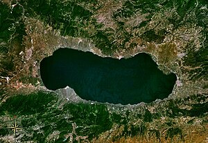
Nicaea (also spelled Nicæa or Nicea, ny-SEE-ə; Latin: [niːˈkae̯.a]), also known as Nikaia (Ancient Greek: Νίκαια, Attic: [nǐːkai̯a], Koine: [ˈnikεa]), was an ancient Greek city in the north-western Anatolian region of Bithynia that is primarily known as the site of the First and Second Councils of Nicaea (the first and seventh Ecumenical councils in the early history of the Christian Church), the Nicene Creed (which comes from the First Council), and as the capital city of the Empire of Nicaea following the Fourth Crusade in 1204, until the recapture of Constantinople by the Byzantines in 1261. Nicaea was also the capital of the Ottomans from 1331 to 1335. The ancient city is located within the modern Turkish city of İznik (whose modern name derives from Nicaea's), and is situated in a fertile basin at the eastern end of Lake Ascanius, bounded by ranges of hills to the north and south.

Battle of Nicaea
Battle between Septimius Severus and Pescennius Niger (193)
Distance: Approx. 206 meters
Latitude and longitude: 40.42866667,29.71866667
The Battle of Nicaea was fought in 193 between the forces of Septimius Severus and his eastern rival, Pescennius Niger. It took place at Nicaea in Asia Minor. Severus defeated his rival, and ended his bid for the Roman Empire the next year at Issus.
Hagia Sophia, İznik
Monument in İznik, Turkey
Distance: Approx. 117 meters
Latitude and longitude: 40.42944444,29.72027778
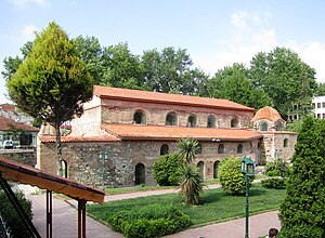
Hagia Sophia mosque (lit. 'the Holy Wisdom'; Ancient Greek: Ἁγία Σοφία, romanized: Hagía Sophía; Turkish: Ayasofya) in İznik (Nicaea) in Bursa Province, Turkey, was built as a Byzantine-era basilican church. Converted into the Orhan Mosque (Turkish: Orhan Camii) after the Ottoman conquest, it was turned into a museum in 1935.

İznik
District and municipality in Bursa, Turkey
Distance: Approx. 63 meters
Latitude and longitude: 40.42916667,29.72111111
İznik (Turkish pronunciation: [izˈnik]) is a municipality and district of Bursa Province, Turkey. Its area is 753 km2, and its population 44,236 (2022). The town is at the site of the ancient Greek city of Nicaea, from which the modern name derives.

Siege of Nicaea (727)
Part of the Arab–Byzantine Wars
Distance: Approx. 143 meters
Latitude and longitude: 40.429,29.7195
The siege of Nicaea of 727 was an unsuccessful attempt by the Umayyad Caliphate to capture the Byzantine city of Nicaea, the capital of the Opsician Theme. Ever since its failure to capture the Byzantine Empire's capital, Constantinople, in 717–718, the Caliphate had launched a series of raids into Byzantine Asia Minor. In 727, the Arab army, led by one of the Caliph's sons, penetrated deep into Asia Minor, sacked two Byzantine fortresses and in late July arrived before Nicaea.

Haji Özbek Mosque
Mosque in İznik, Turkey
Distance: Approx. 189 meters
Latitude and longitude: 40.42933,29.72312
Haji Özbek Mosque (Turkish: Hacı Özbek Camii) is a historical Ottoman mosque in İznik, Turkey.
Green Mosque, İznik
Mosque in İznik, Turkey
Distance: Approx. 507 meters
Latitude and longitude: 40.4297,29.7269
Green Mosque (Turkish: Yeşil Camii) is a historic Ottoman mosque in İznik, Turkey.

Elbeyli, İznik
Neighbourhood in İznik, Bursa, Turkey
Distance: Approx. 6180 meters
Latitude and longitude: 40.48333333,29.73333333
Elbeyli (formerly İlbeyli) is a neighbourhood of the municipality and district of İznik, Bursa Province, Turkey. Its population is 2,267 (2022). Before the 2013 reorganisation, it was a town (belde).

İznik Ultramarathon
Distance: Approx. 133 meters
Latitude and longitude: 40.42916667,29.71972222
İznik Ultramarathon, shortly İznik Ultra, is an international trail running ultramarathon event that takes place at İznik town of Bursa Province in northwestern Turkey. It was established in 2012 with the first race held on 14-15 April. Lasting two days, the race is Turkey's longest single-stage athletic event.
Basilica of Saint Neophytos
Building in Bursa, Türkiye
Distance: Approx. 1012 meters
Latitude and longitude: 40.42577778,29.70975
Basilica of Saint Neophytos is the name of a defunct, underwater basilica in Lake İznik, modern-day Turkey. Coordinates: 40.4258225,29.7095841 visible just off shore.
Ploketta
Town of ancient Bithynia
Distance: Approx. 5030 meters
Latitude and longitude: 40.422294,29.77988
Ploketta was a town of ancient Bithynia. Its name does not occur in ancient writers but is inferred from epigraphic and other evidence. Its site is located near Orta Pinarlar, in Asiatic Turkey.
Çampınar, İznik
Village in Turkey
Distance: Approx. 5553 meters
Latitude and longitude: 40.3811,29.7411
Çampınar is a neighbourhood in the municipality and district of İznik, Bursa Province in Turkey. Its population is 83 (2022).
Weather in this IP's area
clear sky
6 Celsius
4 Celsius
6 Celsius
6 Celsius
1020 hPa
80 %
1020 hPa
970 hPa
10000 meters
2.96 m/s
3.59 m/s
111 degree
7 %

