Country:
 Great Britain
Region:
City:
Latitude and Longitude:
Time Zone:
Postal Code:
IP information under different IP Channel
ip-api
Country
Region
City
ASN
Time Zone
ISP
Blacklist
Proxy
Latitude
Longitude
Postal
Route
IPinfo
Country
Region
City
ASN
Time Zone
ISP
Blacklist
Proxy
Latitude
Longitude
Postal
Route
MaxMind
Country
Region
City
ASN
Time Zone
ISP
Blacklist
Proxy
Latitude
Longitude
Postal
Route
Luminati
Country
GBRegion
eng
City
croydon
ASN
Time Zone
Europe/London
ISP
Zen Internet Ltd
Latitude
Longitude
Postal
db-ip
Country
Region
City
ASN
Time Zone
ISP
Blacklist
Proxy
Latitude
Longitude
Postal
Route
ipdata
Country
Region
City
ASN
Time Zone
ISP
Blacklist
Proxy
Latitude
Longitude
Postal
Route
Popular places and events near this IP address
Addington, London
Human settlement in England
Distance: Approx. 1063 meters
Latitude and longitude: 51.3583,-0.0305
Addington is a village and area in south London, England, within the London Borough of Croydon. It is south of Spring Park, west of Coney Hall, north of New Addington and east of Forestdale and Selsdon, and is 11.1 miles (18 km) south of Charing Cross and 4 miles (6.4 km) south-east of the centre of Croydon.

Addington Palace
Mansion in Addington in Greater London, England
Distance: Approx. 1143 meters
Latitude and longitude: 51.3575,-0.04083333
Addington Palace is an 18th-century mansion in Addington located within the London Borough of Croydon. It was built close to the site of an earlier manor house belonging to the Leigh family. It is particularly known for having been, between 1807 and 1897, the summer residence of the Archbishops of Canterbury.

John Ruskin College
Further education school in South Croydon, Greater London, England
Distance: Approx. 796 meters
Latitude and longitude: 51.351,-0.043
John Ruskin College is a further education college in South Croydon offering full-time vocational courses and apprenticeships as well as part-time courses for adults. In 2019, following a merger with East Surrey College incorporating Reigate School of Art, John Ruskin College became part of Orbital South Colleges. John Ruskin College is located on Selsdon Park Road (A2022), close to the A212 roundabout.

Forestdale, London
Human settlement in England
Distance: Approx. 589 meters
Latitude and longitude: 51.345,-0.038
Forestdale is a residential neighbourhood of southeast London in the London Borough of Croydon. It is sometimes considered to be part of Addington, its ancient and ecclesiastical parish. It is located south of Upper Shirley, east of Selsdon, south-west of Addington's historic centre, north-west of New Addington and north of Farleigh and is east of West Wickham.

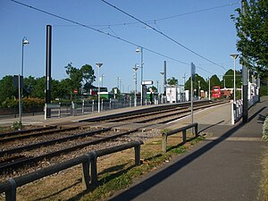
Fieldway tram stop
Tramstop in New Addington, London Borough of Croydon, UK
Distance: Approx. 598 meters
Latitude and longitude: 51.350931,-0.024205
Fieldway tram stop is a light rail stop serving the Fieldway residential area of New Addington, located in the London Borough of Croydon. It is adjacent to a northbound bus stop on the A2022 Lodge Lane.
Addington Village Interchange
Tramlink tram stop in London, England
Distance: Approx. 832 meters
Latitude and longitude: 51.356252,-0.032966
Addington Village Interchange is a light rail stop and associated bus station serving Addington in the London Borough of Croydon in the southern suburbs of London. It opened on 10 May 2000 along with the line to New Addington.

Addington Park
Distance: Approx. 900 meters
Latitude and longitude: 51.356,-0.038
Addington Park is a park situated in Addington in the London Borough of Croydon. The park covers an area of 24.5 acres (9.9 ha).

Gravel Hill tram stop
Tramlink tram stop in London, England
Distance: Approx. 999 meters
Latitude and longitude: 51.35455,-0.04314
Gravel Hill tram stop is a light rail stop serving Addington, in the London Borough of Croydon in the southern suburbs of London. It is the main destination for tourists visiting the historic site of Addington Palace. It is also used by students who attend John Ruskin College and is the nearest stop for Forestdale.

King Henry's Drive tram stop
Tramlink tram stop in London, England
Distance: Approx. 898 meters
Latitude and longitude: 51.345453,-0.020352
King Henry's Drive tram stop is a tram stop serving the Betchworth Way residential area of New Addington, located in the London Borough of Croydon. It is located in the wide central reservation of a dual carriageway.

New Addington North (ward)
Distance: Approx. 1138 meters
Latitude and longitude: 51.354,-0.018
New Addington North is a ward in the London Borough of Croydon, covering part of the New Addington estate in London in the United Kingdom. The ward currently forms part of the Croydon East constituency. The ward returns two councillors every four years.

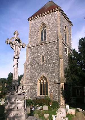
St Mary's Church, Addington
Church in Greater London, England
Distance: Approx. 1075 meters
Latitude and longitude: 51.358453,-0.032254
The Church of St Mary the Blessed Virgin is an Anglican church in Addington, in the Borough of Croydon, London. It is associated with the Archbishops of Canterbury of the 19th century, who lived at nearby Addington Palace: five of the archbishops are buried at the church.
Fieldway (ward)
Distance: Approx. 1138 meters
Latitude and longitude: 51.354,-0.018
Fieldway was a ward in the London Borough of Croydon, covering part of the New Addington estate in London in the United Kingdom. The ward formed part of the Croydon Central constituency. The population of the ward at the 2011 Census was 11,479.
Weather in this IP's area
few clouds
16 Celsius
16 Celsius
15 Celsius
17 Celsius
1013 hPa
72 %
1013 hPa
1001 hPa
10000 meters
4.63 m/s
210 degree
20 %
07:29:17
18:00:49