Country:
 Great Britain
Region:
City:
Latitude and Longitude:
Time Zone:
Postal Code:
IP information under different IP Channel
ip-api
Country
Region
City
ASN
Time Zone
ISP
Blacklist
Proxy
Latitude
Longitude
Postal
Route
IPinfo
Country
Region
City
ASN
Time Zone
ISP
Blacklist
Proxy
Latitude
Longitude
Postal
Route
MaxMind
Country
Region
City
ASN
Time Zone
ISP
Blacklist
Proxy
Latitude
Longitude
Postal
Route
Luminati
Country
GBRegion
eng
City
highwycombe
ASN
Time Zone
Europe/London
ISP
Zen Internet Ltd
Latitude
Longitude
Postal
db-ip
Country
Region
City
ASN
Time Zone
ISP
Blacklist
Proxy
Latitude
Longitude
Postal
Route
ipdata
Country
Region
City
ASN
Time Zone
ISP
Blacklist
Proxy
Latitude
Longitude
Postal
Route
Popular places and events near this IP address

Apsley, Hertfordshire
Human settlement in England
Distance: Approx. 204 meters
Latitude and longitude: 51.7378,-0.4697
Apsley is a village in Hertfordshire, England, in a valley of the Chiltern Hills below the confluence of the River Gade and Bulbourne. It was the site of water mills serving local agriculture and from the early 19th century became an important centre for papermaking. Today it is a suburb of Hemel Hempstead.

Magic Roundabout (Hemel Hempstead)
Roundabout in Hemel Hempstead, Hertfordshire, England
Distance: Approx. 1140 meters
Latitude and longitude: 51.74611111,-0.47305556
"The Magic Roundabout" in Hemel Hempstead, Hertfordshire, England, is the familiar name given to the Plough Roundabout. The familiar name comes from the children's television programme, and is also used for a similar junction in Swindon, the M40 junction in Denham, and the Magic Roundabout in Colchester. The official name relates to a former public house, called The Plough Inn, which was between the junction of what is now Selden Hill and St Albans Road.

Apsley railway station
Railway station in Hertfordshire, England
Distance: Approx. 503 meters
Latitude and longitude: 51.733,-0.463
Apsley railway station is in Apsley, on the southern outskirts of Hemel Hempstead, Hertfordshire, England. One of two railway stations now serving the town, the other is Hemel Hempstead just up the line in Boxmoor. The station is 23 miles (37 km) north west of London Euston on the West Coast Main Line.

River Bulbourne
River in Hertfordshire, England
Distance: Approx. 364 meters
Latitude and longitude: 51.739,-0.471
The River Bulbourne is a small river in Dacorum, Hertfordshire, England. The word bourne derives from the Anglo-Saxon word for a stream. It is an unnavigable tributary of the River Gade, which flows into the River Colne, which in turn is a tributary of the River Thames.

Heath Park Halt railway station
Former railway station in Hertfordshire, England
Distance: Approx. 1036 meters
Latitude and longitude: 51.7445,-0.4752
Heath Park Halt was a railway station in Hemel Hempstead, Hertfordshire in England, UK. It was the terminus for passenger services on the Nickey line, a 9-mile (14 km) branch line which ran from Harpenden into Hemel Hempstead town centre. Passenger services were withdrawn in 1947, and the line through the station was closed completely in 1959. The station was located on an embankment above the junction of Station Road and Corner Hall Road.

Felden
Human settlement in England
Distance: Approx. 893 meters
Latitude and longitude: 51.73,-0.46
Felden is a semi-rural neighbourhood of Hemel Hempstead, Hertfordshire, situated to the south west of the town, close to the railway station. At the 2011 Census the population of the neighbourhood was included in the Dacorum Ward of Bovingdon, Flaunden and Chipperfield. It is separated from the main urban area by main roads, the rail line and Boxmoor.

Shendish Manor
Country house at Apsley
Distance: Approx. 977 meters
Latitude and longitude: 51.7277,-0.4697
Shendish Manor is a country house at Apsley in Hertfordshire.

St John's Church, Boxmoor
Church in Hertfordshire, England
Distance: Approx. 1175 meters
Latitude and longitude: 51.744472,-0.478778
The Church of St John the Evangelist is a Grade II listed church in Boxmoor, Hertfordshire, England.
The Beacon, Hemel Hempstead
Distance: Approx. 693 meters
Latitude and longitude: 51.74,-0.476
The Beacon is a 17-storey block of 272 flats planned to be built in Hemel Hempstead, Hertfordshire, England. The developer Lumiere Developments claims that it will be the "world's most sustainable development". They claim that it will be carbon neutral, as it will generate all the energy it needs, and residents will never have to any energy bills.

Frogmore Paper Mill
Paper mill in Hertfordshire, UK
Distance: Approx. 236 meters
Latitude and longitude: 51.7385,-0.4683
Frogmore Paper Mill is a working paper mill situated in Apsley, Hertfordshire, near Hemel Hempstead. The mill is on an island in the River Gade, which forms part of the Grand Union Canal. It is the oldest mechanical paper mill in the world.
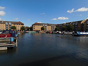
Apsley Marina
Human settlement in England
Distance: Approx. 662 meters
Latitude and longitude: 51.7333,-0.4596
Apsley Marina, also referred to as Apsley Lock Marina, is a basin used for mooring narrowboats on the east side of the Grand Union Canal at Apsley, Hertfordshire, England.

Apsley Mill
Distance: Approx. 500 meters
Latitude and longitude: 51.7334,-0.4624
Apsley Mill was a paper mill at Apsley, near Hemel Hempstead, Hertfordshire, United Kingdom.
Weather in this IP's area
broken clouds
13 Celsius
12 Celsius
11 Celsius
14 Celsius
1031 hPa
83 %
1031 hPa
1021 hPa
10000 meters
4.63 m/s
50 degree
54 %
06:38:47
19:14:40