Country:
 Great Britain
Region:
City:
Latitude and Longitude:
Time Zone:
Postal Code:
IP information under different IP Channel
ip-api
Country
Region
City
ASN
Time Zone
ISP
Blacklist
Proxy
Latitude
Longitude
Postal
Route
IPinfo
Country
Region
City
ASN
Time Zone
ISP
Blacklist
Proxy
Latitude
Longitude
Postal
Route
MaxMind
Country
Region
City
ASN
Time Zone
ISP
Blacklist
Proxy
Latitude
Longitude
Postal
Route
Luminati
Country
GBRegion
eng
City
highwycombe
ASN
Time Zone
Europe/London
ISP
Zen Internet Ltd
Latitude
Longitude
Postal
db-ip
Country
Region
City
ASN
Time Zone
ISP
Blacklist
Proxy
Latitude
Longitude
Postal
Route
ipdata
Country
Region
City
ASN
Time Zone
ISP
Blacklist
Proxy
Latitude
Longitude
Postal
Route
Popular places and events near this IP address

Streatham
Human settlement in England
Distance: Approx. 943 meters
Latitude and longitude: 51.4279,-0.1235
Streatham ( STRET-əm) is a district in south London, England. Centred 5 miles (8 km) south of Charing Cross, it lies mostly within the London Borough of Lambeth, with some parts extending into the neighbouring London Borough of Wandsworth. Streatham was in Surrey before becoming part of the County of London in 1889, and then Greater London in 1965.

Streatham Common
Park in Streatham, London, England
Distance: Approx. 527 meters
Latitude and longitude: 51.42222222,-0.12444444
Streatham Common is a large open space on the southern edge of Streatham in the London Borough of Lambeth. The shallow sloping lower (western) half of the common is mostly mowed grass, and the upper (eastern) half is mostly woodland with some small areas of gorse scrub and acid grassland. The eastern half has been designated a Local Nature Reserve.

Norbury railway station
Railway station in London, England
Distance: Approx. 1027 meters
Latitude and longitude: 51.4114,-0.1214
Norbury railway station is a National Rail station in the Norbury area of the London Borough of Croydon in south London. It is on the Brighton Main Line, 7 miles 36 chains (12.0 km) down the line from London Victoria. The station is operated by Southern, which also provides all train services.
Norbury High School for Girls
Academy in Thornton Heath, Greater London, England
Distance: Approx. 1049 meters
Latitude and longitude: 51.41099,-0.11517
Norbury High School for Girls is a secondary school with academy status for girls aged 11–19. It is located in Thornton Heath, Greater London, England.

St Joseph's College, Upper Norwood
Voluntary aided school in London, England
Distance: Approx. 730 meters
Latitude and longitude: 51.4206,-0.107
St Joseph's College is a 11-18 Voluntary-Aided, Lasallian, all boys' secondary school and sixth form with academy status, located in the Upper Norwood area of the London Borough of Croydon, England. The school is a single sex educational establishment for boys up to the age of 16 and operates a co-educational sixth-form for boys and girls aged 16 to 18.
Bishop Thomas Grant School
Voluntary aided school in Streatham, London, England
Distance: Approx. 536 meters
Latitude and longitude: 51.425,-0.11916667
Bishop Thomas Grant School (BTG) is a coeducational Roman Catholic secondary school and sixth form, situated in the Streatham area of the London Borough of Lambeth, England. The school is named after the first Bishop of Southwark, Thomas Grant (1816-1870) who was named in the First Vatican Council. The school was opened on 9 September 1959.
Streatham South (ward)
Distance: Approx. 1107 meters
Latitude and longitude: 51.415,-0.131
Streatham South ward was an administrative division of the London Borough of Lambeth, United Kingdom from 1965 to 2022. It was the most southerly ward of the borough and bordered with Croydon, Merton, and Wandsworth. The population of the ward at the 2011 Census was 14,336.
Streatham Wells (ward)
Distance: Approx. 1094 meters
Latitude and longitude: 51.43,-0.12
Streatham Wells ward is an administrative division of the London Borough of Lambeth, United Kingdom. It contains part of Streatham town centre to the east of the A23 Streatham High Road. The population of the ward at the 2011 Census was 14,906.
J. W. Hobbs' Ground
Distance: Approx. 952 meters
Latitude and longitude: 51.41203,-0.11402
J. W. Hobbs' Ground was a cricket ground in Norbury, Surrey. The ground was constructed in 1885 within the grounds of Norbury Hall by local philanthropist J. W. Hobbs. The first recorded match on the ground was in 1887, when C. I. Thornton's XI played the Gentlemen of Canada.
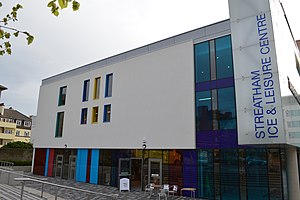
Streatham Ice and Leisure Centre
Leisure centre in Streatham, England
Distance: Approx. 1050 meters
Latitude and longitude: 51.4248,-0.1308
Streatham Ice and Leisure Centre is an ice rink and leisure centre in Streatham, London. It is the only Olympic-sized skating rink in the city, and is the home ice of the Streatham IHC and Streatham Storm ice hockey teams. It replaced the older Streatham Ice Arena.

Biggin Wood
Preserved ancient woodland
Distance: Approx. 856 meters
Latitude and longitude: 51.4158,-0.1075
Biggin Wood (also known as Biggin Woods) is an area of ancient oak woodland situated within the London Borough of Croydon. The London Wildlife Trust is currently working with Croydon Council and the Friends of Biggin Wood to improve the site for wildlife, as a part of The Great North Wood Project. Biggin Wood is home to a range of British wildlife, including the Great spotted woodpecker, English Oak and Bluebell.

Norwood Grove
Ornamental park in London Borough of Croydon, UK
Distance: Approx. 318 meters
Latitude and longitude: 51.41790009,-0.11501259
Norwood Grove is an ornamental urban park in the northern extent of the London Borough of Croydon, by whom it is managed, although the most westerly part lies within the London Borough of Lambeth. It is bordered to the south-west by Covington Way, to the south-east by Gibson's Hill and to the north-east by Copgate Path, itself also referred to as 'Norwood Grove', and also by Ryecroft Road. To the north-west the grounds adjoin those of The Rookery (managed by the Borough of Lambeth) which itself adjoins Streatham Common of which Norwood Grove was once a part.
Weather in this IP's area
clear sky
13 Celsius
13 Celsius
12 Celsius
15 Celsius
1031 hPa
82 %
1031 hPa
1022 hPa
10000 meters
3.09 m/s
60 degree
06:37:33
19:13:06