Country:
 Netherlands
Region:
City:
Latitude and Longitude:
Time Zone:
Postal Code:
IP information under different IP Channel
ip-api
Country
Region
City
ASN
Time Zone
ISP
Blacklist
Proxy
Latitude
Longitude
Postal
Route
IPinfo
Country
Region
City
ASN
Time Zone
ISP
Blacklist
Proxy
Latitude
Longitude
Postal
Route
MaxMind
Country
Region
City
ASN
Time Zone
ISP
Blacklist
Proxy
Latitude
Longitude
Postal
Route
Luminati
Country
 DE
DEASN
Time Zone
Europe/Berlin
ISP
Host Europe GmbH
Latitude
Longitude
Postal
db-ip
Country
Region
City
ASN
Time Zone
ISP
Blacklist
Proxy
Latitude
Longitude
Postal
Route
ipdata
Country
Region
City
ASN
Time Zone
ISP
Blacklist
Proxy
Latitude
Longitude
Postal
Route
Popular places and events near this IP address

Duivendrecht
Village in North Holland, Netherlands
Distance: Approx. 421 meters
Latitude and longitude: 52.33333333,4.93333333
Duivendrecht (Dutch pronunciation: [ˈdœyvə(n)ˌdrɛxt]) is a village in the Dutch province of North Holland. It is a part of the municipality of Ouder-Amstel, and lies about 6 km southeast of Amsterdam’s city centre. It is a suburb of Amsterdam.
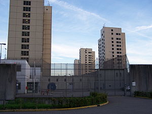
Bijlmerbajes
Prison complex in Amsterdam, the Netherlands
Distance: Approx. 543 meters
Latitude and longitude: 52.3385,4.9242
The Bijlmerbajes was a prison complex (which was permanently closed in June 2016) in Amsterdam, the Netherlands, near the Amsterdam Amstel railway station. The official name is Penitentiaire Inrichting Over-Amstel, although it is also known as Penitentiaire Inrichting De Stadspoort or Penitentiaire Inrichtingen Amsterdam. Bijlmerbajes is part of the Custodial Institutions Agency (Dienst Justitiële Inrichtingen, DJI) of the Dutch Ministry of Justice within the Dutch criminal justice system.
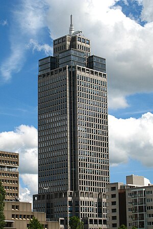
Rembrandt Tower
Office skyscraper in Amsterdam
Distance: Approx. 1317 meters
Latitude and longitude: 52.3444,4.9167
Rembrandt Tower (Dutch: Rembrandttoren, pronounced [ˈrɛmbrɑnˌtoːrə(n)]) is an office skyscraper in Amsterdam. It has a height of 135 metres, 36 floors and it has a spire which extends its height to 150 metres. It was constructed from 1991 to 1994.
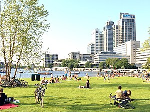
Amsteldorp
Neighborhood of Amsterdam in North Holland, Netherlands
Distance: Approx. 916 meters
Latitude and longitude: 52.33722222,4.91833333
Amsteldorp is a neighborhood of Amsterdam, Netherlands. The neighborhood dates from the 1920s but many houses were built in 1947–48 and in the 1950s. The Amstel Station is located within this area, which was built in 1939, and the tallest building in the neighbourhood is Rembrandt Tower, with a height of 150 metres.

Betondorp
Neighbourhood of Amsterdam in North Holland, Netherlands
Distance: Approx. 848 meters
Latitude and longitude: 52.34027778,4.94305556
Betondorp (Dutch pronunciation: [bəˈtɔndɔr(ə)p]; Concrete Village) is a neighbourhood of Amsterdam, Netherlands. It was built in the 1920s as an experiment in building affordable housing with new, cheap building materials, chiefly concrete. The houses are built in a sober, minimalist form of Art Deco.
Omval
Neighbourhood of Amsterdam in North Holland, Netherlands
Distance: Approx. 1376 meters
Latitude and longitude: 52.33388889,4.91222222
Omval is a neighbourhood situated on a peninsula on the eastern shore of the Amstel river in Amsterdam, Netherlands. It is situated south of the Weesperzijde neighbourhood and next to the Amsterdam Amstel railway station in the borough of Amsterdam-Oost. In the 1990s, it became the site of a major business district featuring the Rembrandt Tower, the tallest skyscraper in Amsterdam.

Spaklerweg metro station
Amsterdam Metro station in the Netherlands
Distance: Approx. 830 meters
Latitude and longitude: 52.34027778,4.92083333
Spaklerweg is an Amsterdam Metro station in the industrial area Overamstel of Amsterdam, Netherlands. The station opened in 1982 and is served by 3 lines, the 51 (Amsterdam Centraal - Isolatorweg), 53 (Amsterdam Centraal - Gaasperplas) and 54 (Amsterdam Centraal - Gein). The metro station is only accessible with an OV-chipkaart or GVB Travel Pass.

Overamstel metro station
Metro station in Amsterdam, Netherlands
Distance: Approx. 1188 meters
Latitude and longitude: 52.33138889,4.91694444
Overamstel is an Amsterdam Metro station in the industrial area Overamstel of Amsterdam, Netherlands.

Van der Madeweg metro station
Metro station in Duivendrecht, Netherlands
Distance: Approx. 817 meters
Latitude and longitude: 52.32972222,4.93027778
Van der Madeweg is an Amsterdam Metro station in Duivendrecht, Netherlands.
JOS Watergraafsmeer
Dutch football club
Distance: Approx. 459 meters
Latitude and longitude: 52.34111111,4.93138889
JOS Watergraafsmeer is an association football club from the Amsterdam district Watergraafsmeer. In 2010 the club had around 500 registered members. The Saturday team plays in the Derde Klasse, while the Sunday team competes in the Vierde Divisie.
Museum tot zover
Museum in Amsterdam, Netherlands
Distance: Approx. 1115 meters
Latitude and longitude: 52.34611111,4.93861111
The Nederlands Uitvaart Museum Tot Zover (Dutch Funeral Museum So Far) is a museum in Amsterdam, Netherlands that displays the various funerary practices of the various cultures present in the Netherlands, with the view that these funerary practices provide a better understanding of these cultures. The museum is located in De Nieuwe Ooster, a memorial park in Amsterdam that includes a cemetery and crematorium. The original building was designed as a caretaker’s residence by Adriaan Willem Weissman (1858–1923), who was a Dutch city architect best known for designing the Stedelijk Museum.

Mondriaan Tower
Distance: Approx. 1241 meters
Latitude and longitude: 52.344,4.9176
The Mondriaan Tower (Dutch: Mondriaantoren) is a skyscraper located at Amstelplein 6-8, near the Amstel river, in Amsterdam, Netherlands. The modern office building is 120 meters high, has 30 office floors and an underlying parking garage. Mondriaan Tower was completed in 2002.
Weather in this IP's area
clear sky
17 Celsius
17 Celsius
16 Celsius
17 Celsius
1028 hPa
87 %
1028 hPa
1028 hPa
9000 meters
5.14 m/s
60 degree
3 %
07:21:44
19:46:19