Country:
 Serbia
Region:
City:
Latitude and Longitude:
Time Zone:
Postal Code:
IP information under different IP Channel
ip-api
Country
Region
City
ASN
Time Zone
ISP
Blacklist
Proxy
Latitude
Longitude
Postal
Route
IPinfo
Country
Region
City
ASN
Time Zone
ISP
Blacklist
Proxy
Latitude
Longitude
Postal
Route
MaxMind
Country
Region
City
ASN
Time Zone
ISP
Blacklist
Proxy
Latitude
Longitude
Postal
Route
Luminati
Country
RSASN
Time Zone
Europe/Belgrade
ISP
Serbian Open Exchange DOO
Latitude
Longitude
Postal
db-ip
Country
Region
City
ASN
Time Zone
ISP
Blacklist
Proxy
Latitude
Longitude
Postal
Route
ipdata
Country
Region
City
ASN
Time Zone
ISP
Blacklist
Proxy
Latitude
Longitude
Postal
Route
Popular places and events near this IP address
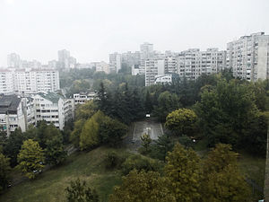
Voždovac
Municipality in Belgrade, Serbia
Distance: Approx. 419 meters
Latitude and longitude: 44.78333333,20.48333333
Voždovac (Serbian Cyrillic: Вождовац, pronounced [ʋǒːʒdoʋats]) is a municipality of the city of Belgrade. According to the 2022 census results, the municipality has a population of 174,864 inhabitants. The municipality is located in the south-central part of the urban area of Belgrade and in the central section of the wider Belgrade City area.
Dušanovac, Belgrade
Urban neighbourhood in Voždovac, Belgrade, Serbia
Distance: Approx. 457 meters
Latitude and longitude: 44.78305556,20.48305556
Dušanovac (Serbian Cyrillic: Душановац, pronounced [duʃǎːnoʋats]), is an urban and historical neighbourhood of Belgrade, the capital of Serbia. It is located in the municipality of Voždovac.
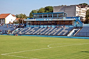
FK Obilić Stadium
Multi-purpose stadium in Belgrade, Serbia
Distance: Approx. 875 meters
Latitude and longitude: 44.79158611,20.49464444
Obilić Stadium (Serbian: Стадион ФК Обилић / Stadion FK Obilić) is a football stadium in Belgrade, Serbia, located in Vračar municipality. The stadium has a seating capacity for 4,508 people. The venue was the home ground of FK Obilić until 2015 and was used during the 2011 UEFA European Under-17 Championship.

Marinkova Bara
Urban neighbourhood in Voždovac, Belgrade, Serbia
Distance: Approx. 587 meters
Latitude and longitude: 44.78166667,20.48916667
Marinkova Bara (Serbian: Маринкова Бара) is an urban neighborhood of Belgrade, the capital of Serbia. It is located in the municipality of Voždovac.
Pašino Brdo
Urban neighbourhood in Vračar, Belgrade, Serbia
Distance: Approx. 191 meters
Latitude and longitude: 44.78805556,20.48722222
Pašino Brdo (Serbian Cyrillic: Пашино Брдо) is an urban neighborhood of Belgrade, the capital of Serbia. It is located in Belgrade's municipality of Voždovac, while the northern section belongs to the municipality of Vračar. It is also known as Lekino Brdo (Serbian Cyrillic: Лекино Брдо) after the top Communist official, Aleksandar Ranković (1909–80), whose nickname was Leka ("Leka's hill").
Šumice, Belgrade
Urban neighbourhood in Voždovac, Belgrade, Serbia
Distance: Approx. 225 meters
Latitude and longitude: 44.78583333,20.48888889
Šumice (Serbian Cyrillic: Шумице, pronounced [ʃûmit͡sɛ]) is an urban neighborhood of Belgrade, the capital of Serbia. It is located in Belgrade's municipality of Voždovac. It is also the name of a park-forest within the neighbourhood.
Crveni Krst, Belgrade
Urban neighbourhood in Vračar / Zvezdara, Belgrade, Serbia
Distance: Approx. 1153 meters
Latitude and longitude: 44.79674444,20.48834444
Crveni Krst (Serbian Cyrillic: Црвени Крст, pronounced [tsrʋɛni kř̩ːst], "Red Cross") or colloquially just Krst (Крст, "Cross"), is an urban neighborhood of Belgrade, the capital of Serbia. It is located in Belgrade's municipalities of Vračar (larger part) and Zvezdara (part of Đeram).

Konjarnik
Urban neighbourhood in Voždovac / Zvezdara, Belgrade, Serbia
Distance: Approx. 1146 meters
Latitude and longitude: 44.78333333,20.5
Konjarnik (Serbian Cyrillic: Коњарник, pronounced [kɔ̌ɲaːrniːk]) is an urban neighborhood of Belgrade, the capital of Serbia. It is divided between Belgrade's municipalities of Voždovac and Zvezdara (roughly Konjarnik I, Konjarnik II and Konjarnik III, respectively). As a large neighborhood, it has several sub-neighborhoods of its own, including Denkova Bašta, Učiteljsko Naselje and Rudo.
Singidunum University
Private university in Belgrade, Serbia
Distance: Approx. 738 meters
Latitude and longitude: 44.78216667,20.47913889
Singidunum University (Serbian: Универзитет Сингидунум, romanized: Univerzitet Singidunum) is a private university in Belgrade, Serbia which offers undergraduate, master and doctoral academics studies in three scientific fields – social sciences and humanities; technical sciences; and natural sciences and mathematics. The university consists of five faculties, and has 8,827 enrolled students as of 2022–23 school year, which makes it the largest private university in Serbia. The first faculty was founded in 1999, and the University itself was established on 17 January 2005.
SC Šumice
Distance: Approx. 406 meters
Latitude and longitude: 44.7845,20.4905
Šumice Cultural and Sports Center (Serbian Cyrillic: Центар за културу и спорт Шумице) is an indoor sports arena located in Voždovac, Belgrade, Serbia. The hall is used for basketball, handball, indoor football, volleyball, and other sports. The venue was opened on 24 May 1974 and was originally known as the "Vоždovac Pioneers Home".
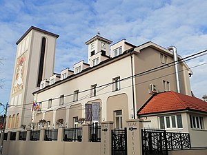
Cathedral of the Blessed Virgin Mary, Belgrade
Church in Belgrade, Serbia
Distance: Approx. 1193 meters
Latitude and longitude: 44.7944,20.476
The Cathedral of the Blessed Virgin Mary (Serbian: Катедрала Блажене Девице Марије, romanized: Katedrala Blažene Device Marije) also called the Catholic Cathedral of Belgrade is since 1988 the cathedral church of the Roman Catholic Archdiocese of Belgrade. It is located at 75 Hadži Milentijeva Street in the Belgrade's neighborhood of Neimar, in the municipality of Vračar. The construction of the church began on 1938.

Church of St. Anthony of Padua, Belgrade
Church in Belgrade, Serbia
Distance: Approx. 1196 meters
Latitude and longitude: 44.7968,20.4905
Catholic church designed by Jože Plečnik located in Bregalnička 14, Zvezdara.
Weather in this IP's area
clear sky
10 Celsius
7 Celsius
10 Celsius
10 Celsius
1022 hPa
54 %
1022 hPa
1006 hPa
10000 meters
6.17 m/s
110 degree
06:58:46
17:46:51