Country:
 Brazil
Region:
City:
Latitude and Longitude:
Time Zone:
Postal Code:
IP information under different IP Channel
ip-api
Country
Region
City
ASN
Time Zone
ISP
Blacklist
Proxy
Latitude
Longitude
Postal
Route
IPinfo
Country
Region
City
ASN
Time Zone
ISP
Blacklist
Proxy
Latitude
Longitude
Postal
Route
MaxMind
Country
Region
City
ASN
Time Zone
ISP
Blacklist
Proxy
Latitude
Longitude
Postal
Route
Luminati
Country
BRRegion
rj
City
saogoncalo
ASN
Time Zone
America/Sao_Paulo
ISP
ALTA REDE CORPORATE NETWORK TELECOM LTDA - EPP
Latitude
Longitude
Postal
db-ip
Country
Region
City
ASN
Time Zone
ISP
Blacklist
Proxy
Latitude
Longitude
Postal
Route
ipdata
Country
Region
City
ASN
Time Zone
ISP
Blacklist
Proxy
Latitude
Longitude
Postal
Route
Popular places and events near this IP address
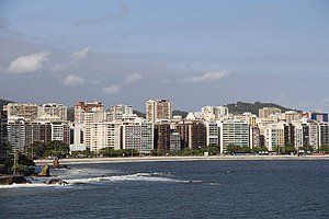
Niterói
Municipality in Southeast, Brazil
Distance: Approx. 7637 meters
Latitude and longitude: -22.88333333,-43.10361111
Niterói (Portuguese pronunciation: [niteˈɾɔj]) is a municipality in the state of Rio de Janeiro, in the southeast region of Brazil. It lies across Guanabara Bay, facing the city of Rio de Janeiro and forming part of the Rio de Janeiro Metropolitan Area. It was the capital of Rio de Janeiro, as marked by its golden mural crown, from 1834 to 1894 and again from 1903 to 1975.
Barreto, Niterói
Distance: Approx. 5454 meters
Latitude and longitude: -22.86004,-43.09971
Barreto is a middle-class neighborhood in the northern zone Niterói, bordering the municipality of São Gonçalo and by the coast of Guanabara Bay. It was built along the way of Niterói-Manilha road.
Baldeador
Distance: Approx. 5400 meters
Latitude and longitude: -22.87666667,-43.06138889
Baldeador is one of the 48 administrative districts in which the city of Niterói, Rio de Janeiro in Brazil is divided. It lies in the northern zone of the city, bordering the municipality of São Gonçalo. Its name derives from the Portuguese word for railway junction.
Ilha da Conceição
Distance: Approx. 7533 meters
Latitude and longitude: -22.87175,-43.1155
Ilha da Conceição (Portuguese for Conception Island) is an island, and one of the 48 administrative districts in which the city of Niterói, Rio de Janeiro in Brazil is divided. It lies in the northern zone of the city, in the Guanabara Bay.

São Gonçalo, Rio de Janeiro
Municipality in Southeast, Brazil
Distance: Approx. 573 meters
Latitude and longitude: -22.82694444,-43.05388889
São Gonçalo (Portuguese pronunciation: [sɐ̃w ɡõˈsalu]) is a municipality in Rio de Janeiro, Brazil, in the Southeast region. It is located in the Metropolitan Region of Rio de Janeiro, having land limits with the municipalities of Niterói, Maricá and Itaboraí, and a maritime limit, by Guanabara Bay, with the capital, Rio de Janeiro. According to the 2022 census, it has a population of 896,744 inhabitants, making it the second most populous municipality in the state and the 18th most populous in the country.
Alcântara River
River in Brazil
Distance: Approx. 6640 meters
Latitude and longitude: -22.78333333,-43.01666667
The Alcântara River is a river of Rio de Janeiro state in southeastern Brazil.
Maria Paula River
River in Brazil
Distance: Approx. 6218 meters
Latitude and longitude: -22.81666667,-43
The Maria Paula River is a river of Rio de Janeiro state in southeastern Brazil.
Pendotiba River
River in Brazil
Distance: Approx. 6691 meters
Latitude and longitude: -22.88333333,-43.03333333
The Pendotiba River is a river of Rio de Janeiro state in southeastern Brazil.
Cubango, Niterói
Human settlement in Brazil
Distance: Approx. 7989 meters
Latitude and longitude: -22.891,-43.097
See Cubango for namesakes, notably in Africa Cubango is a neighborhood located in the northwest of the city Niterói, Rio de Janeiro (state), Brazil. It is famous for hosting the samba school Acadêmicos do Cubango that competes in the Rio Carnival.
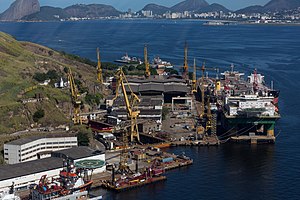
Estaleiro Mauá
Distance: Approx. 8936 meters
Latitude and longitude: -22.8772,-43.1283
Mauá Shipyard SA is the oldest private Brazilian shipyard, being surpassed only by the state-owned Arsenal da Marinha do Brasil, which was founded in 1808. Its origin is the Anglo-Brazilian company Estabelecimento de Fundição e Estaleiros da Ponta d'Areia, located in Niterói, Rio de Janeiro, and was bought on August 11, 1846, by Irineu Evangelista de Sousa, at the time Baron of Mauá. In 2000, the company entered into a joint-venture with Jurong Shipyard in Singapore, creating the company Mauá Jurong S/A (MJ).

Estabelecimento de Fundição e Estaleiros Ponta da Areia
Distance: Approx. 8936 meters
Latitude and longitude: -22.8772,-43.1283
Estabelecimento de Fundição e Estaleiros Ponta da Areia (English: Foundry Establishment and Shipyards Ponta da Areia) was one of the first shipbuilding industries in Brazil, having been founded by Charles Colman in 1844 and acquired in 1846 by Irineu Evangelista de Sousa, future Baron and Viscount of Mauá.

Real Transportes Aéreos Flight 435
Distance: Approx. 7365 meters
Latitude and longitude: -22.7986086,-43.1235004
The REAL Transportes Aéreos Flight 435, connecting Belo Horizonte to Rio de Janeiro, mysteriously crashed into the waters of Baía de Guanabara near Ilha dos Ferros on June 24, 1960.
Weather in this IP's area
overcast clouds
24 Celsius
24 Celsius
22 Celsius
24 Celsius
1019 hPa
67 %
1019 hPa
1017 hPa
10000 meters
8.23 m/s
220 degree
100 %
05:47:32
17:46:34