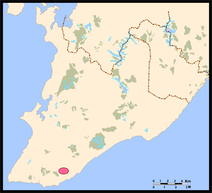
Country:
Region:
City:
Latitude and Longitude:
Time Zone:
Postal Code:
IP information under different IP Channel
ip-api
Country
Region
City
ASN
Time Zone
ISP
Blacklist
Proxy
Latitude
Longitude
Postal
Route
Luminati
Country
Region
ba
City
ruybarbosa
ASN
Time Zone
America/Bahia
ISP
Screen Saver Informatica LTDA
Latitude
Longitude
Postal
IPinfo
Country
Region
City
ASN
Time Zone
ISP
Blacklist
Proxy
Latitude
Longitude
Postal
Route
db-ip
Country
Region
City
ASN
Time Zone
ISP
Blacklist
Proxy
Latitude
Longitude
Postal
Route
ipdata
Country
Region
City
ASN
Time Zone
ISP
Blacklist
Proxy
Latitude
Longitude
Postal
Route
Popular places and events near this IP address

Salvador, Bahia
Capital city of Bahia, Brazil
Distance: Approx. 6237 meters
Latitude and longitude: -12.97472222,-38.47666667
Salvador is a Brazilian municipality and capital city of the state of Bahia. Situated in the Zona da Mata in the Northeast Region of Brazil, Salvador is recognized throughout the country and internationally for its cuisine, music, and architecture. The African influence in many cultural aspects of the city makes it a center of Afro-Brazilian culture.

Barradão
Football stadium in Salvador, Brazil
Distance: Approx. 2899 meters
Latitude and longitude: -12.91916667,-38.42722222
Estádio Manoel Barradas, is a multi-purpose stadium in Salvador, Brazil. It is currently used mostly for football matches. The stadium has a current maximum capacity of 34,535 spectators.

Estádio de Pituaçu
Distance: Approx. 1180 meters
Latitude and longitude: -12.94663611,-38.41701944
Estádio Governador Roberto Santos, usually known as Estádio de Pituaçu, is a football stadium located in Salvador, Bahia state, Brazil. The stadium is owned by the Government of Bahia state and it was built in 1979. Its formal name honors Roberto Santos, who was a federal deputy, the governor of Bahia state from 1975 to 1979, a professor at the Universidade Federal da Bahia's Faculty of Medicine, and was the Minister of Health during José Sarney's government.

Itaigara (neighbourhood)
Distance: Approx. 5983 meters
Latitude and longitude: -12.98333333,-38.46666667
Itaigara is a neighbourhood located in the southeastern zone of Salvador, Bahia. Modern and bold lies in a region "noble" of the capital Bahia, inhabited mainly by people with high purchasing power. Owes its name to the indigenous origin and means "of stone canoe" (Ita: "stone"; Igaram: "boat" or "water lady").
Caminho das Árvores
Neighborhood in Salvador, Brazil
Distance: Approx. 5983 meters
Latitude and longitude: -12.98333333,-38.46666667
Caminho das Árvores is a neighborhood located in the southeastern zone of Salvador, Bahia in Brazil. This neighborhood is a mixed of residential and trade area, with majority presence of wealthy classes.

Siege of Salvador (1822–1823)
Conflict during the Brazilian War of Independence
Distance: Approx. 6237 meters
Latitude and longitude: -12.97472222,-38.47666667
The siege of Salvador occurred during the Brazilian War of Independence, during which the newly formed Brazilian army, under the command of French general Pierre Labatut, attempted to capture the city of Salvador in Bahia from its Portuguese defenders. The siege lasted from 2 March 1822 until 2 July 1823, finally ending when the Portuguese commander, Madeira de Melo, surrendered his forces to the Brazilians.

Jorge Amado University Center
Distance: Approx. 2106 meters
Latitude and longitude: -12.93769611,-38.40998519
The Centro Universitário Jorge Amado (Jorge Amado University Center, often abbreviated as Unijorge) is a private institution founded in 1999 and located in the city of Salvador, Bahia, Brazil. It has more than 30 undergraduate courses and some post-graduate courses.

Legislative Assembly of Bahia
Distance: Approx. 420 meters
Latitude and longitude: -12.94861111,-38.42944444
The Legislative Assembly of Bahia (Portuguese: Assembleia Legislativa da Bahia, ALBA) is the unicameral legislature of the Brazilian state of Bahia. It is currently based in the Luís Eduardo Magalhães building in the administrative centre of Bahia]] (Centro Administrativo da Bahia, CAB) in the Salvador neighbourhood. It has 63 state deputies elected by proportional representation.
Timeline of Salvador, Bahia
Distance: Approx. 6237 meters
Latitude and longitude: -12.974722,-38.476667
The following is a timeline of the history of the city of Salvador, Bahia state, Brazil.
Praia do Forte
Municipality in Northeast, Brazil
Distance: Approx. 6237 meters
Latitude and longitude: -12.97472222,-38.47666667
Praia do Forte is a long beach with a small village 80 km away from the city of Salvador, Bahia. The beach is known for its clear waters, white sand, natural pools, rivers and an ecological reserve of native flora and fauna.

Circuito Ayrton Senna
Distance: Approx. 258 meters
Latitude and longitude: -12.9475,-38.42805556
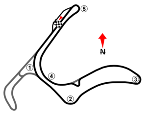
The Circuito Ayrton Senna, also known as CAB circuit, was a 2.724 km (1.693 mi) street circuit opened in 2009, located in Salvador, Bahia. The curves that made up the circuit's 2.724 km (1.693 mi) were the Curva dos Orixás, Curva do Acarajé, Curva da Balança, Curva do Dendê and Curva da Vitória. Cacá Bueno and Allam Khodair were the most successful drivers on the circuit, both won 2 races.
Pan American School of Bahia
International school in Brazil
Distance: Approx. 3134 meters
Latitude and longitude: -12.95639,-38.40129
The Pan American School of Bahia (PASB), is an American international school in Salvador, Bahia, Brazil for students from pre-kindergarten through high school. The school was founded in 1960, on a small campus in Campo Grande, and in 1974 the current campus was built in Patamares. It is cooperatively owned by parents and operates as a non-profit, non-denominational, college-preparatory institution for International and Brazilian students.
Weather in this IP's area
broken clouds
27 Celsius
28 Celsius
27 Celsius
27 Celsius
1015 hPa
65 %
1015 hPa
1008 hPa
10000 meters
4.12 m/s
80 degree
75 %
04:58:19
17:36:33