187.86.133.130 - IP Lookup: Free IP Address Lookup, Postal Code Lookup, IP Location Lookup, IP ASN, Public IP
Country:
Region:
City:
Location:
Time Zone:
Postal Code:
IP information under different IP Channel
ip-api
Country
Region
City
ASN
Time Zone
ISP
Blacklist
Proxy
Latitude
Longitude
Postal
Route
Luminati
Country
Region
rs
City
pelotas
ASN
Time Zone
America/Sao_Paulo
ISP
VETORIALNET INF. E SERVICOS DE INTERNET LTDA
Latitude
Longitude
Postal
IPinfo
Country
Region
City
ASN
Time Zone
ISP
Blacklist
Proxy
Latitude
Longitude
Postal
Route
IP2Location
187.86.133.130Country
Region
rio grande do sul
City
chui
Time Zone
America/Sao_Paulo
ISP
Language
User-Agent
Latitude
Longitude
Postal
db-ip
Country
Region
City
ASN
Time Zone
ISP
Blacklist
Proxy
Latitude
Longitude
Postal
Route
ipdata
Country
Region
City
ASN
Time Zone
ISP
Blacklist
Proxy
Latitude
Longitude
Postal
Route
Popular places and events near this IP address
Chuí
Place in Sul, Brazil
Distance: Approx. 46 meters
Latitude and longitude: -33.69111111,-53.45666667
Chuí (Portuguese pronunciation: [ʃuˈi]) is a municipality located in the state of Rio Grande do Sul, Brazil. It's the southernmost town of Brazil, located at latitude 33°41′0″S. A border town, it shares its name with sister city Chuy, Uruguay. The two towns constitute one contiguous urban area, divided by a border street called Avenida Internacional, called Avenida Uruguai in Brazil, a situation also seen in a few other Brazilian border points, such as between Santana do Livramento (Brazil) and Rivera (Uruguay).

Chuy
City in Rocha, Uruguay
Distance: Approx. 703 meters
Latitude and longitude: -33.69638889,-53.46
Chuy (Spanish pronunciation: [ˈtʃwi]) is a city in the extreme east of Uruguay, in the Rocha Department, 340 kilometres (211 mi) northeast of Montevideo. It lies on the border with Brazil, separated from its Brazilian sister town of Chuí only by a shared avenue that serves as the border, and by the Arroyo Chuy (stream) to the east. Chuy's population was 9,675 in 2011.

Dieciocho de Julio
Town in Rocha Department, Uruguay
Distance: Approx. 9193 meters
Latitude and longitude: -33.68333333,-53.55555556
Dieciocho de Julio or 18 de Julio is a small town in the Rocha Department of southeastern Uruguay.
Puimayen
Resort in Rocha Department, Uruguay
Distance: Approx. 9953 meters
Latitude and longitude: -33.76666667,-53.4
Puimayen is a resort on the Atlantic Coast in the Rocha Department of southeastern Uruguay near the Brazilian border.

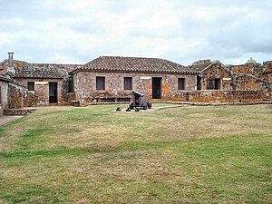
Fuerte San Miguel (Uruguay)
Distance: Approx. 7610 meters
Latitude and longitude: -33.689401,-53.538848
Fuerte de San Miguel is a military fortification in the small town of Dieciocho de Julio in the Rocha Department of eastern Uruguay. It was erected in 1737 by the Portuguese, having abandoned the attempt at building a fort in Maldonado. It was constructed of large, heavy stones to create the tall towers (four bastions), thick walls and sturdy ramparts to withstand the onslaught of wars fought against the Spanish invaders which was instrumental in Uruguay evolving as an independent nation.

Barra del Chuy
Resort in Rocha Department, Uruguay
Distance: Approx. 9568 meters
Latitude and longitude: -33.75555556,-53.38888889
Barra del Chuy is a resort (balneario) in the Rocha Department of southeastern Uruguay. Its name means Mouth of Chui (stream). It is the last coastal resort of Uruguay, bordering Brazil to the southeast with the stream Arroyo Chui as the natural border.
Chuí Lighthouse
Lighthouse
Distance: Approx. 9619 meters
Latitude and longitude: -33.74194444,-53.37305556
Chuí Lighthouse (Portuguese: Farol do Chuí) is an active lighthouse in Barra do Chuí, at the mouth of Chuí Stream, just 1 kilometre (0.62 mi) from the Uruguayan border; the lighthouse is the southernmost of all the Brazilian lights.
Chui Mosque
Mosque in Chuí, Rio Grande do Sul, Brazil
Distance: Approx. 424 meters
Latitude and longitude: -33.68841667,-53.46036111
The Chui Mosque (Portuguese: Mesquita Chui) is a mosque in Chuí, Rio Grande do Sul, Brazil.
Weather in this IP's area
clear sky
17 Celsius
17 Celsius
17 Celsius
17 Celsius
1014 hPa
89 %
1014 hPa
1013 hPa
10000 meters
2.64 m/s
4.72 m/s
59 degree

